Estimated payment $2,469/month
Highlights
- Open Floorplan
- Transitional Architecture
- Main Floor Primary Bedroom
- Apex Elementary School Rated A-
- Wood Flooring
- Granite Countertops
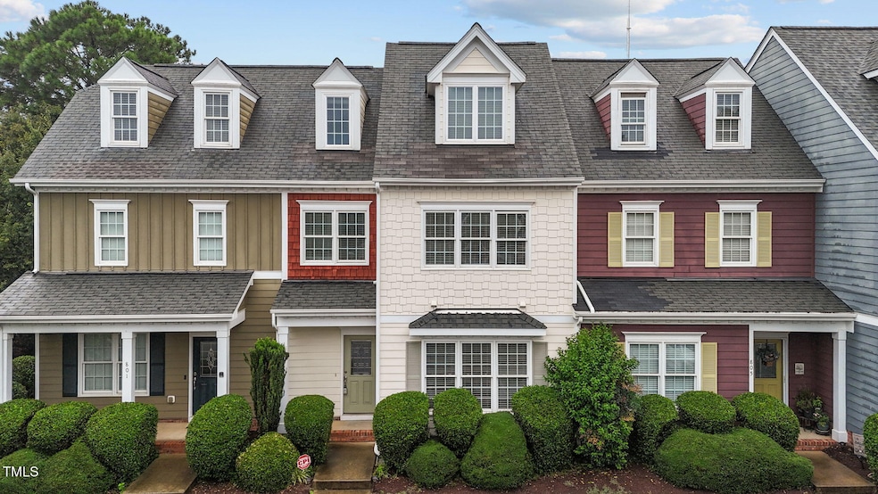
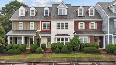
About This Home
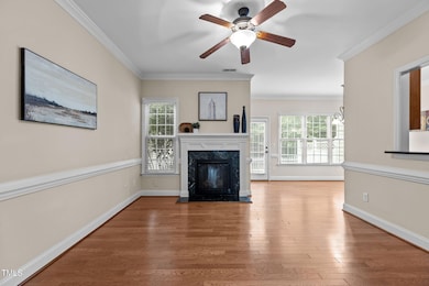
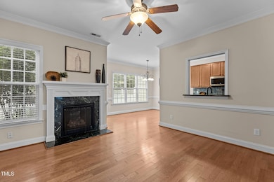
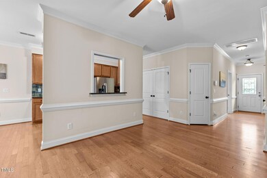
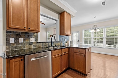
Welcome home — where charm meets convenience in the heart of Apex. This 4-bedroom townhome offers a rare first-floor primary suite, hardwood floors throughout the main level, and a kitchen with granite counters, stainless steel appliances, stone backsplash, and rich wood cabinets and opens to the dining area and living room with a cozy gas fireplace. Upstairs, find three bedrooms plus a walk-up attic with 650+ sq ft for storage or future living space. Enjoy a fenced patio with tree-lined privacy or a short walk/bike to the neighborhood pool. HOA covers roof, exterior maintenance, and pool access. Just minutes to Ting Park, Pleasant Park, Beaver Creek shopping, and Downtown Apex — where active living and small-town charm meet.
Townhouse Details
Home Type
- Townhome
Est. Annual Taxes
- $3,016
Year Built
- Built in 2007
Lot Details
- 1,742 Sq Ft Lot
- Two or More Common Walls
- Back Yard Fenced
HOA Fees
- $246 Monthly HOA Fees
Home Design
- Transitional Architecture
- Traditional Architecture
- Slab Foundation
- Architectural Shingle Roof
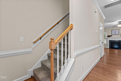
Interior Spaces
- 1,840 Sq Ft Home
- 2-Story Property
- Open Floorplan
- Smooth Ceilings
- Ceiling Fan
- Entrance Foyer
- Family Room with Fireplace
- Dining Room
- Pull Down Stairs to Attic
Kitchen
- Oven
- Electric Cooktop
- Microwave
- Ice Maker
- Dishwasher
- Granite Countertops
- Disposal
Flooring
- Wood
- Carpet
Bedrooms and Bathrooms
- 4 Bedrooms
- Primary Bedroom on Main
- Walk-In Closet
- Bathtub with Shower
Laundry
- Laundry on main level
- Dryer
- Washer
Parking
- 2 Open Parking Spaces
- Parking Lot
Outdoor Features
- Patio
- Outdoor Storage
Schools
- Apex Elementary School
- Apex Middle School
- Apex High School
Utilities
- Forced Air Heating and Cooling System
Listing and Financial Details
- Assessor Parcel Number 0742808258
Community Details
Overview
- Association fees include ground maintenance, maintenance structure, pest control, road maintenance
- The Groves Association, Phone Number (919) 362-1460
- The Groves Subdivision
- Maintained Community
Recreation
- Community Pool
Map
Home Values in the Area
Average Home Value in this Area
Tax History
| Year | Tax Paid | Tax Assessment Tax Assessment Total Assessment is a certain percentage of the fair market value that is determined by local assessors to be the total taxable value of land and additions on the property. | Land | Improvement |
|---|---|---|---|---|
| 2025 | $3,085 | $351,016 | $65,000 | $286,016 |
| 2024 | $3,016 | $351,016 | $65,000 | $286,016 |
| 2023 | $2,684 | $242,812 | $40,000 | $202,812 |
| 2022 | $2,520 | $242,812 | $40,000 | $202,812 |
| 2021 | $2,424 | $242,812 | $40,000 | $202,812 |
| 2020 | $2,400 | $242,812 | $40,000 | $202,812 |
| 2019 | $2,069 | $180,373 | $30,000 | $150,373 |
| 2018 | $1,949 | $180,373 | $30,000 | $150,373 |
| 2017 | $1,815 | $180,373 | $30,000 | $150,373 |
| 2016 | $1,789 | $180,373 | $30,000 | $150,373 |
| 2015 | $1,840 | $181,171 | $30,000 | $151,171 |
| 2014 | $1,774 | $181,171 | $30,000 | $151,171 |
Property History
| Date | Event | Price | List to Sale | Price per Sq Ft |
|---|---|---|---|---|
| 10/12/2025 10/12/25 | Pending | -- | -- | -- |
| 09/19/2025 09/19/25 | Price Changed | $375,000 | -6.0% | $204 / Sq Ft |
| 09/11/2025 09/11/25 | Price Changed | $399,000 | -0.3% | $217 / Sq Ft |
| 08/08/2025 08/08/25 | For Sale | $400,000 | -- | $217 / Sq Ft |
Purchase History
| Date | Type | Sale Price | Title Company |
|---|---|---|---|
| Warranty Deed | $253,000 | None Available | |
| Warranty Deed | $208,000 | None Available |
Mortgage History
| Date | Status | Loan Amount | Loan Type |
|---|---|---|---|
| Open | $189,750 | Adjustable Rate Mortgage/ARM | |
| Previous Owner | $204,232 | FHA |
Source: Doorify MLS
MLS Number: 10114779
APN: 0742.20-80-8258-000
Disclaimer: Certain information contained herein is derived from information provided by parties other than Homes.com. All information provided is deemed reliable, but is not guaranteed to be accurate and should be independently verified.
![]() Some IDX listings have been excluded from this IDX display. Brokers make an effort to deliver accurate information, but buyers should independently verify any information on which they will rely in a transaction. The listing broker shall not be responsible for any typographical errors, misinformation, or misprints, and they shall be held totally harmless from any damages arising from reliance upon this data. This data is provided exclusively for consumers’ personal, non-commercial use. Listings marked with an icon are provided courtesy of the Doorify MLS, Inc. of North Carolina, Internet Data Exchange Database. Closed (sold) listings may have been listed and/or sold by a real estate firm other than the firm(s) featured on this website. Closed data is not available until the sale of the property is recorded in the MLS. Home sale data is not an appraisal, CMA, competitive or comparative market analysis, or home valuation of any property. Copyright 2025 Doorify MLS, Inc. of North Carolina. All rights reserved.
Some IDX listings have been excluded from this IDX display. Brokers make an effort to deliver accurate information, but buyers should independently verify any information on which they will rely in a transaction. The listing broker shall not be responsible for any typographical errors, misinformation, or misprints, and they shall be held totally harmless from any damages arising from reliance upon this data. This data is provided exclusively for consumers’ personal, non-commercial use. Listings marked with an icon are provided courtesy of the Doorify MLS, Inc. of North Carolina, Internet Data Exchange Database. Closed (sold) listings may have been listed and/or sold by a real estate firm other than the firm(s) featured on this website. Closed data is not available until the sale of the property is recorded in the MLS. Home sale data is not an appraisal, CMA, competitive or comparative market analysis, or home valuation of any property. Copyright 2025 Doorify MLS, Inc. of North Carolina. All rights reserved.
- 295 Williams Grove Ln Unit Lot 67
- 285 Williams Grove Ln Unit Lot 65
- 285 Williams Grove Ln
- 281 Williams Grove Ln
- 298 Williams Grove Ln N
- 294 Williams Grove Ln Unit 69
- 294 Williams Grove Ln
- 286 Williams Grove Ln Unit Lot 71
- 278 Williams Grove Ln Unit Lot 73
- 268 Williams Grove Ln Unit Lot 75
- 262 Williams Grove Ln
- 262 Williams Grove Ln Unit Lot 76
- 218 Williams Grove Ln
- 214 Williams Grove Ln
- 257 Williams Grove Ln Unit Lot 58
- 253 Williams Grove Ln
- 273 Williams Grove Ln Unit Lot 62
- 269 Williams Grove Ln
- 265 Williams Grove Ln
- 245 Williams Grove Ln
