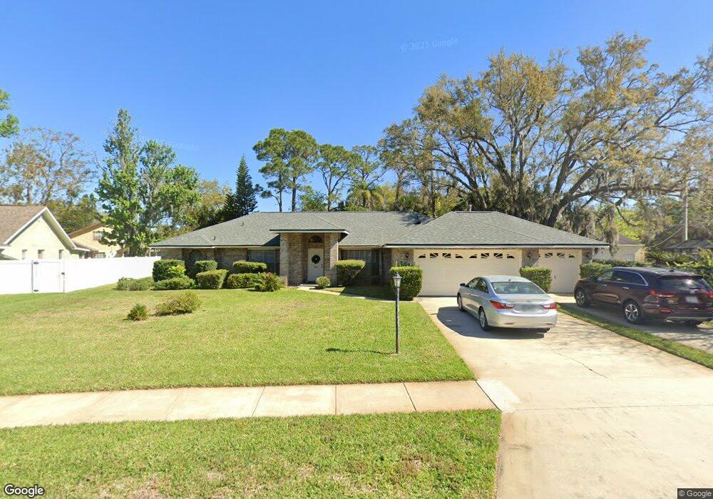
803 Sanders Rd Port Orange, FL 32127
South Port Orange NeighborhoodEstimated Value: $420,000 - $488,000
4
Beds
2
Baths
2,198
Sq Ft
$204/Sq Ft
Est. Value
About This Home
This home is located at 803 Sanders Rd, Port Orange, FL 32127 and is currently estimated at $449,278, approximately $204 per square foot. 803 Sanders Rd is a home located in Volusia County with nearby schools including Sugar Mill Elementary School, Silver Sands Middle School, and Spruce Creek High School.
Ownership History
Date
Name
Owned For
Owner Type
Purchase Details
Closed on
May 10, 2022
Sold by
Blanchard Cynthia A
Bought by
Blanchard Cynthia A and Gembala Robert F
Current Estimated Value
Purchase Details
Closed on
Mar 4, 2014
Sold by
Blanchard Cynthia A
Bought by
Blanchard Cynthia A and Gembala Robert F
Purchase Details
Closed on
Oct 15, 1990
Bought by
Blanchard Cynthia A
Purchase Details
Closed on
Oct 15, 1989
Bought by
Blanchard Cynthia A
Purchase Details
Closed on
Jul 15, 1989
Bought by
Blanchard Cynthia A
Create a Home Valuation Report for This Property
The Home Valuation Report is an in-depth analysis detailing your home's value as well as a comparison with similar homes in the area
Home Values in the Area
Average Home Value in this Area
Purchase History
| Date | Buyer | Sale Price | Title Company |
|---|---|---|---|
| Blanchard Cynthia A | -- | None Listed On Document | |
| Blanchard Cynthia A | -- | Attorney | |
| Blanchard Cynthia A | $100 | -- | |
| Blanchard Cynthia A | $158,400 | -- | |
| Blanchard Cynthia A | $29,600 | -- |
Source: Public Records
Tax History Compared to Growth
Tax History
| Year | Tax Paid | Tax Assessment Tax Assessment Total Assessment is a certain percentage of the fair market value that is determined by local assessors to be the total taxable value of land and additions on the property. | Land | Improvement |
|---|---|---|---|---|
| 2025 | $4,939 | $361,652 | -- | -- |
| 2024 | $4,939 | $351,460 | -- | -- |
| 2023 | $4,939 | $341,224 | $0 | $0 |
| 2022 | $3,995 | $298,813 | $0 | $0 |
| 2021 | $3,788 | $263,046 | $0 | $0 |
| 2020 | $3,613 | $255,222 | $0 | $0 |
| 2019 | $3,320 | $241,701 | $0 | $0 |
| 2018 | $3,241 | $233,144 | $0 | $0 |
| 2017 | $3,219 | $227,210 | $0 | $0 |
| 2016 | $3,153 | $217,990 | $0 | $0 |
| 2015 | $3,115 | $209,812 | $0 | $0 |
| 2014 | $3,904 | $179,840 | $0 | $0 |
Source: Public Records
Map
Nearby Homes
- 811 Brimfield Ct
- 823 Wooddusk Dr
- 4508 Alder Dr
- 69 Tropical Ct
- 66 Tropical Ct
- 4577 Miles Dr
- 4589 Alder Dr
- 772 Horseman Dr
- 53 Windward Ct
- 139 Royal Palm Cir
- 91 Royal Palm Cir
- 722 Raven Rock Ct
- 4590 Miles Dr
- 723 Raven Rock Ct
- 5402 Marshfield Dr
- 13 Royal Palm Cir
- 932 Sabalwood Ct
- 750 Horseman Dr
- 962 Stonybrook Cir
- 124 Royal Palm Cir
- 805 Sanders Rd
- 801 Sanders Rd
- 809 Brimfield Ct
- 807 Brimfield Ct
- 805 Brimfield Ct
- 803 Brimfield Ct
- 801 Brimfield Ct
- 807 Sanders Rd
- 813 Brimfield Ct
- 815 Brimfield Ct
- 4600 Spruce Creek Rd
- 4590 Spruce Creek Rd
- 4610 Spruce Creek Rd
- 816 Brimfield Ct
- 809 Sanders Rd
- 817 Brimfield Ct
- 4562 Woodcove Dr
- 4570 Spruce Creek Rd
- 4561 Woodcove Dr
- 818 Brimfield Ct