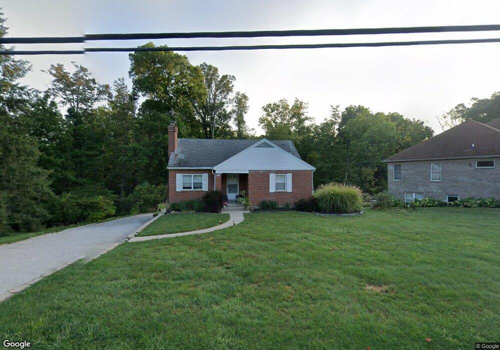
8034 Forest Rd Cincinnati, OH 45255
Estimated Value: $275,000 - $371,000
3
Beds
1
Bath
1,498
Sq Ft
$209/Sq Ft
Est. Value
About This Home
This home is located at 8034 Forest Rd, Cincinnati, OH 45255 and is currently estimated at $312,834, approximately $208 per square foot. 8034 Forest Rd is a home located in Hamilton County with nearby schools including Ayer Elementary School, Nagel Middle School, and Anderson High School.
Ownership History
Date
Name
Owned For
Owner Type
Purchase Details
Closed on
Feb 6, 2008
Sold by
King Constance and Odell Stephen Tom
Bought by
King Constance and Odell Stephen Tom
Current Estimated Value
Purchase Details
Closed on
Jan 30, 2008
Sold by
Estate Of Edna May Odell
Bought by
Odell Stephen Tom and King Constance
Purchase Details
Closed on
Jan 18, 2008
Sold by
Fancher Raymond M
Bought by
Odell Stephen Tom and King Constance
Purchase Details
Closed on
Oct 12, 2007
Sold by
Odell Stephen Tom and King Constance
Bought by
Fancher Raymond M
Home Financials for this Owner
Home Financials are based on the most recent Mortgage that was taken out on this home.
Original Mortgage
$121,600
Interest Rate
6.33%
Mortgage Type
Purchase Money Mortgage
Create a Home Valuation Report for This Property
The Home Valuation Report is an in-depth analysis detailing your home's value as well as a comparison with similar homes in the area
Home Values in the Area
Average Home Value in this Area
Purchase History
| Date | Buyer | Sale Price | Title Company |
|---|---|---|---|
| King Constance | -- | None Available | |
| Odell Stephen Tom | -- | None Available | |
| Odell Stephen Tom | -- | Lawyers Title Of Cincinnati | |
| Fancher Raymond M | $128,000 | Lawyers Title Of Cincinnati |
Source: Public Records
Mortgage History
| Date | Status | Borrower | Loan Amount |
|---|---|---|---|
| Previous Owner | Fancher Raymond M | $121,600 |
Source: Public Records
Tax History
| Year | Tax Paid | Tax Assessment Tax Assessment Total Assessment is a certain percentage of the fair market value that is determined by local assessors to be the total taxable value of land and additions on the property. | Land | Improvement |
|---|---|---|---|---|
| 2025 | $4,602 | $73,486 | $19,201 | $54,285 |
| 2023 | $4,255 | $73,486 | $19,201 | $54,285 |
| 2022 | $3,414 | $52,465 | $15,498 | $36,967 |
| 2021 | $3,334 | $52,465 | $15,498 | $36,967 |
| 2020 | $3,372 | $52,465 | $15,498 | $36,967 |
| 2019 | $3,287 | $46,432 | $13,717 | $32,715 |
| 2018 | $3,079 | $46,432 | $13,717 | $32,715 |
| 2017 | $2,905 | $46,432 | $13,717 | $32,715 |
| 2016 | $2,721 | $42,459 | $13,566 | $28,893 |
| 2015 | $2,642 | $42,459 | $13,566 | $28,893 |
| 2014 | $2,644 | $42,459 | $13,566 | $28,893 |
| 2013 | $2,452 | $41,626 | $13,300 | $28,326 |
Source: Public Records
Map
Nearby Homes
- 1125 Wittshire Ln Unit 130
- 7988 Woodruff Rd
- 8016 Hignite Ct
- 881 Asbury Rd
- 8303 Tidewater Ct
- 7754 Forest Rd
- 849 Shawnee Trace Ct
- 792 Farmsworth Ct
- 684 Balbriggan Ct
- 1357 Oak Ct
- 1363 Oak Ct
- 7978 Nagel Village Dr
- 8345 Cherry Ln
- 1400 Sigma Cir
- 8512 Prilla Ln
- 8022 Stonegate Dr
- 559 Asbury Rd
- 906 Woodlyn Dr N Unit 4
- 854 Woodlyn Dr S
- 7968 State Rd
- 8046 Forest Rd
- 8594 Forest Rd
- 8039 Forest Rd
- 8020 Forest Rd
- 8074 Forest Rd
- 8058 Forest Rd
- 8047 Forest Rd
- 8057 Forest Rd
- 8086 Forest Rd
- 8069 Forest Rd
- 8081 Forest Rd
- 1070 Witt Rd
- 8073 Forest Rd
- 8100 Forest Rd
- 953 Merritt Grove Ln
- 967 Merritt Grove Ln
- 8110 Forest Rd
- 961 Merritt Grove Ln
- 945 Merritt Grove Ln
- 937 Merritt Grove Ln