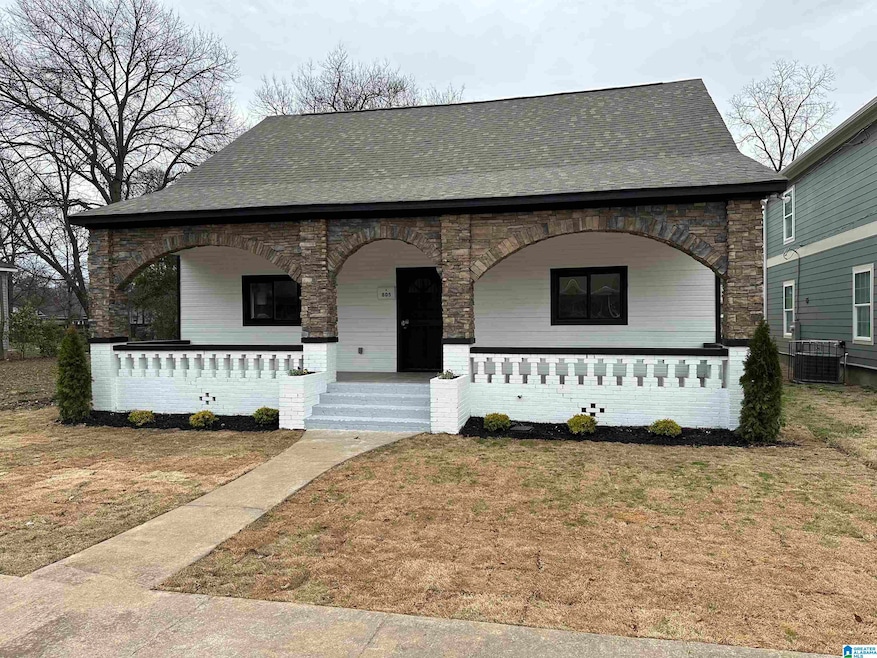
805 49th St N Birmingham, AL 35212
Woodlawn NeighborhoodEstimated payment $1,315/month
Highlights
- City View
- No HOA
- Eat-In Kitchen
- Attic
- Porch
- Brick Veneer
About This Home
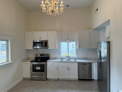
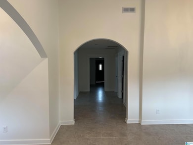
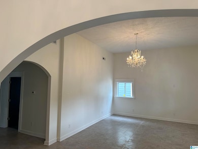
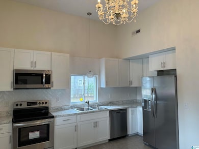
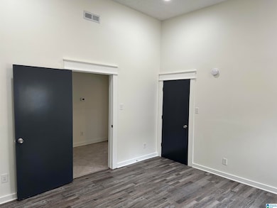
You'll fall in love ...where old historical charm and modern upgrades unite to create a beautiful cottage that awaits new owners. The front porch boast the original brick arches that welcome you to sit a minute as well as carry you inside where you are greeted with warm colored hardwood floors that flow throughout. This home offer an oversized great room designed for entertaining and a kitchen that meets the needs and wants of the chef in you. Gorgeous white cabinets, stainless steel appliances and endless countertops perfect for creating your favorite entrees. The neutral color schemes give you the perfect backdrop to design your own style throughout each room in this unique house. Imagine all the celebrations you can host and the countless memories that can be made here in your new home. The back lawn is a perfect spot for a fire pit and grilling area to bring all those parties out back for more living space. Book your showing today and explore the charm and beauty first hand.
Home Details
Home Type
- Single Family
Est. Annual Taxes
- $603
Year Built
- Built in 1930
Parking
- On-Street Parking
Home Design
- Brick Veneer
- HardiePlank Type
- Stone
Interior Spaces
- Recessed Lighting
- Window Treatments
- City Views
- Attic
Kitchen
- Eat-In Kitchen
- Laminate Countertops
Bedrooms and Bathrooms
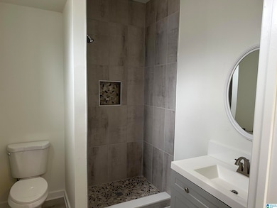
- 3 Bedrooms
- 2 Full Bathrooms
Laundry
- Laundry on main level
- Washer and Electric Dryer Hookup
Schools
- Barrett Elementary School
- Ossie Ware Mitchell Middle School
- Woodlawn High School
Additional Features
- Porch
- 6,970 Sq Ft Lot
- Electric Water Heater
Community Details
- No Home Owners Association
Map
Home Values in the Area
Average Home Value in this Area
Tax History
| Year | Tax Paid | Tax Assessment Tax Assessment Total Assessment is a certain percentage of the fair market value that is determined by local assessors to be the total taxable value of land and additions on the property. | Land | Improvement |
|---|---|---|---|---|
| 2024 | $603 | $10,260 | -- | -- |
| 2022 | $458 | $7,300 | $1,460 | $5,840 |
| 2021 | $420 | $6,770 | $1,460 | $5,310 |
| 2020 | $415 | $6,720 | $1,460 | $5,260 |
| 2019 | $415 | $6,720 | $0 | $0 |
| 2018 | $353 | $5,860 | $0 | $0 |
| 2017 | $353 | $5,860 | $0 | $0 |
| 2016 | $0 | $5,860 | $0 | $0 |
| 2015 | $353 | $5,860 | $0 | $0 |
| 2014 | $407 | $5,780 | $0 | $0 |
| 2013 | $407 | $5,780 | $0 | $0 |
Property History
| Date | Event | Price | List to Sale | Price per Sq Ft |
|---|---|---|---|---|
| 10/07/2025 10/07/25 | For Sale | $240,000 | -- | $162 / Sq Ft |
Purchase History
| Date | Type | Sale Price | Title Company |
|---|---|---|---|
| Special Warranty Deed | $8,500 | None Available | |
| Warranty Deed | $70,000 | -- |
Mortgage History
| Date | Status | Loan Amount | Loan Type |
|---|---|---|---|
| Previous Owner | $69,300 | Purchase Money Mortgage |
Source: Greater Alabama MLS
MLS Number: 21433468
APN: 23-00-20-4-014-010.000
Disclaimer: Certain information contained herein is derived from information provided by parties other than Homes.com. All information provided is deemed reliable, but is not guaranteed to be accurate and should be independently verified.
![]() IDX information is provided exclusively for personal, non-commercial use, and may not be used for any purpose other than to identify prospective properties consumers may be interested in purchasing. Information is deemed reliable but not guaranteed.
IDX information is provided exclusively for personal, non-commercial use, and may not be used for any purpose other than to identify prospective properties consumers may be interested in purchasing. Information is deemed reliable but not guaranteed.
- 801 48th St N
- 833 49th St N
- 821 50th St N
- 837 49th St N
- 236 48th St N
- 833 50th St N
- 912 48th St N
- 5112 2nd Ave N
- 924 47th Place N
- 5105 Georgia Rd
- 942 47th Place N
- 934 47th St N
- 749 45th Place N
- 4636 9th Terrace N
- 808 45th Place N
- 821 45th St N
- 1112 47th St N
- 1023 46th St N
- 4630 11th Ave N
- 4910 3rd Ave S
- 5009 2nd Ave N
- 824 45th St Ensley
- 972 53rd St N
- 4902 3rd Ave S
- 530 52nd St S
- 4901 6th Ave S
- 4345 2nd Ave S
- 4284 2nd Ave S Unit C
- 209 43rd St S
- 4445 6th Ave S
- 4252 3rd Ave S
- 708 56th St S
- 5321 Crestwood Blvd
- 4211 3rd Ave S
- 5820 7th Ave S
- 4115 4th Ave S Unit 202
- 4115 4th Ave S Unit 102
- 4115 4th Ave S Unit 101
- 4713 9th Ave S
- 919 47th Way S
