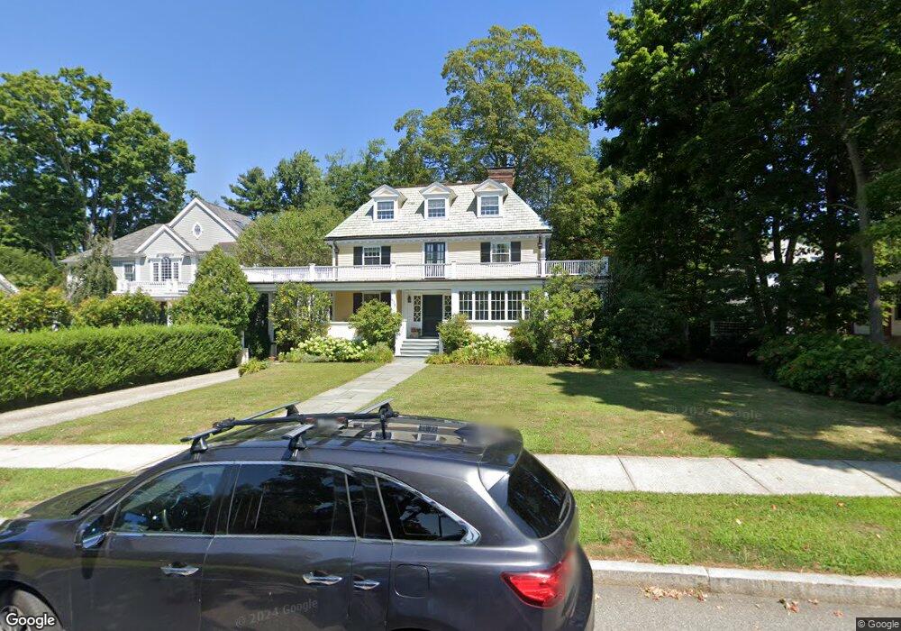
805 Commonwealth Ave Newton Center, MA 02459
Newton Centre NeighborhoodEstimated Value: $2,671,813 - $3,082,000
7
Beds
5
Baths
4,264
Sq Ft
$665/Sq Ft
Est. Value
About This Home
This home is located at 805 Commonwealth Ave, Newton Center, MA 02459 and is currently estimated at $2,834,703, approximately $664 per square foot. 805 Commonwealth Ave is a home located in Middlesex County with nearby schools including Mason Rice Elementary School, Charles E Brown Middle School, and Newton North High School.
Ownership History
Date
Name
Owned For
Owner Type
Purchase Details
Closed on
Feb 28, 2018
Sold by
Power W David W and Power Helen M
Bought by
Power W David W and Power Helene M
Current Estimated Value
Purchase Details
Closed on
May 27, 1994
Sold by
805 Commonwealth Rt and Mcsweeney Mary
Bought by
Power W David and Power Helene M
Home Financials for this Owner
Home Financials are based on the most recent Mortgage that was taken out on this home.
Original Mortgage
$335,000
Interest Rate
8.22%
Mortgage Type
Purchase Money Mortgage
Create a Home Valuation Report for This Property
The Home Valuation Report is an in-depth analysis detailing your home's value as well as a comparison with similar homes in the area
Home Values in the Area
Average Home Value in this Area
Purchase History
| Date | Buyer | Sale Price | Title Company |
|---|---|---|---|
| Power W David W | -- | -- | |
| Power W David | $480,000 | -- | |
| Power W David W | -- | -- | |
| Power W David W | $480,000 | -- |
Source: Public Records
Mortgage History
| Date | Status | Borrower | Loan Amount |
|---|---|---|---|
| Previous Owner | Power W David W | $335,000 |
Source: Public Records
Tax History Compared to Growth
Tax History
| Year | Tax Paid | Tax Assessment Tax Assessment Total Assessment is a certain percentage of the fair market value that is determined by local assessors to be the total taxable value of land and additions on the property. | Land | Improvement |
|---|---|---|---|---|
| 2025 | $25,226 | $2,574,100 | $1,369,600 | $1,204,500 |
| 2024 | $24,391 | $2,499,100 | $1,329,700 | $1,169,400 |
| 2023 | $23,495 | $2,308,000 | $1,033,900 | $1,274,100 |
| 2022 | $22,481 | $2,137,000 | $957,300 | $1,179,700 |
| 2021 | $21,692 | $2,016,000 | $903,100 | $1,112,900 |
| 2020 | $21,047 | $2,016,000 | $903,100 | $1,112,900 |
| 2019 | $20,454 | $1,957,300 | $876,800 | $1,080,500 |
| 2018 | $20,114 | $1,859,000 | $782,300 | $1,076,700 |
| 2017 | $19,502 | $1,859,000 | $782,300 | $1,076,700 |
| 2016 | $18,653 | $1,639,100 | $689,700 | $949,400 |
| 2015 | $17,785 | $1,531,900 | $644,600 | $887,300 |
Source: Public Records
Map
Nearby Homes
- 3 Cedar St
- 73 Elmore St
- 34 Morton Rd
- 887 Commonwealth Ave
- Lots 2 & 3 Chapin Rd
- Lot 3 Chapin Rd
- Lot 2 Chapin Rd
- 1004 Centre St
- 95 Blake St
- 61 Lakeview Ave
- 54 Garland Rd
- 44 Irving St
- 21 Francis St Unit 21A
- 23 Francis St Unit 23-1
- 31 W Boulevard Rd
- 44 Blake St Unit 2
- 300 Cabot St
- 1114 Beacon St Unit 106
- 1114 Beacon St Unit 203
- 1114 Beacon St Unit 111
- 811 Commonwealth Ave
- 799 Commonwealth Ave
- 63 Cedar St
- 12 Vineyard Rd
- 18 Vineyard Rd
- 819 Commonwealth Ave
- 55 Cedar St
- 24 Vineyard Rd
- 789 Commonwealth Ave
- 66 Cedar St
- 30 Vineyard Rd
- 825 Commonwealth Ave
- 60 Cedar St
- 11 Vineyard Rd
- 17 Vineyard Rd
- 93 Cedar St
- 45 Cedar St
- 781 Commonwealth Ave
- 808 Commonwealth Ave
- 36 Vineyard Rd