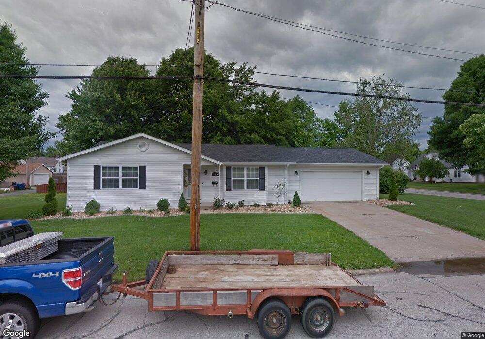
805 Constance St Collinsville, IL 62234
Estimated Value: $176,000 - $191,000
3
Beds
2
Baths
1,391
Sq Ft
$133/Sq Ft
Est. Value
About This Home
This home is located at 805 Constance St, Collinsville, IL 62234 and is currently estimated at $185,161, approximately $133 per square foot. 805 Constance St is a home located in Madison County with nearby schools including John A Renfro Elementary School, Dorris Intermediate School, and Collinsville Middle School.
Ownership History
Date
Name
Owned For
Owner Type
Purchase Details
Closed on
Feb 3, 2012
Sold by
Wilke Dennis R and Wilke Terry L
Bought by
Banovz Michael J
Current Estimated Value
Home Financials for this Owner
Home Financials are based on the most recent Mortgage that was taken out on this home.
Original Mortgage
$85,500
Outstanding Balance
$58,604
Interest Rate
3.9%
Mortgage Type
New Conventional
Estimated Equity
$126,557
Create a Home Valuation Report for This Property
The Home Valuation Report is an in-depth analysis detailing your home's value as well as a comparison with similar homes in the area
Home Values in the Area
Average Home Value in this Area
Purchase History
| Date | Buyer | Sale Price | Title Company |
|---|---|---|---|
| Banovz Michael J | $95,000 | Abstract & Title Inc |
Source: Public Records
Mortgage History
| Date | Status | Borrower | Loan Amount |
|---|---|---|---|
| Open | Banovz Michael J | $85,500 |
Source: Public Records
Tax History Compared to Growth
Tax History
| Year | Tax Paid | Tax Assessment Tax Assessment Total Assessment is a certain percentage of the fair market value that is determined by local assessors to be the total taxable value of land and additions on the property. | Land | Improvement |
|---|---|---|---|---|
| 2024 | $2,780 | $49,490 | $7,200 | $42,290 |
| 2023 | $2,780 | $45,800 | $6,660 | $39,140 |
| 2022 | $2,619 | $41,140 | $5,960 | $35,180 |
| 2021 | $2,255 | $38,650 | $5,600 | $33,050 |
| 2020 | $2,155 | $36,870 | $5,340 | $31,530 |
| 2019 | $2,083 | $35,610 | $5,160 | $30,450 |
| 2018 | $1,714 | $29,470 | $4,870 | $24,600 |
| 2017 | $1,707 | $28,880 | $4,770 | $24,110 |
| 2016 | $1,788 | $28,880 | $4,770 | $24,110 |
| 2015 | $1,657 | $28,130 | $4,650 | $23,480 |
| 2014 | $1,657 | $28,130 | $4,650 | $23,480 |
| 2013 | $1,657 | $28,130 | $4,650 | $23,480 |
Source: Public Records
Map
Nearby Homes
- 308 Brown Ave
- 1210 Constance St
- 1120 Williams St
- 501 Spring
- 617 N Morrison Ave
- 1224 Cedar Ridge Ct
- 123 W Wickliffe Ave
- 919 Vine St
- 921 Prospect St
- 203 Greenfield Dr
- 0 Strong Ave
- 1227 Ridge Ave
- 0 N Keebler Ave
- 706 Illinois Ave
- 123 Elliot St
- 580 N Guernsey St
- 238 Mill St
- 414 Bunker Hill Dr
- 404 E Church St
- 22 Brookwood Dr
- 420 Wadsworth St
- 803 Constance St
- 323 Brown Ave
- 804 Constance St
- 321 Brown Ave
- 801 Constance St
- 414 Wadsworth St
- 502 Wadsworth St
- 403 Brown Ave
- 423 Wadsworth St
- 319 Brown Ave
- 425 Wadsworth St
- 408 Wadsworth St
- 419 Wadsworth St
- 417 Wadsworth St
- 315 Brown Ave
- 409 Brown Ave
- 501 Wadsworth St
- 514 Wadsworth St
- 406 Wadsworth St