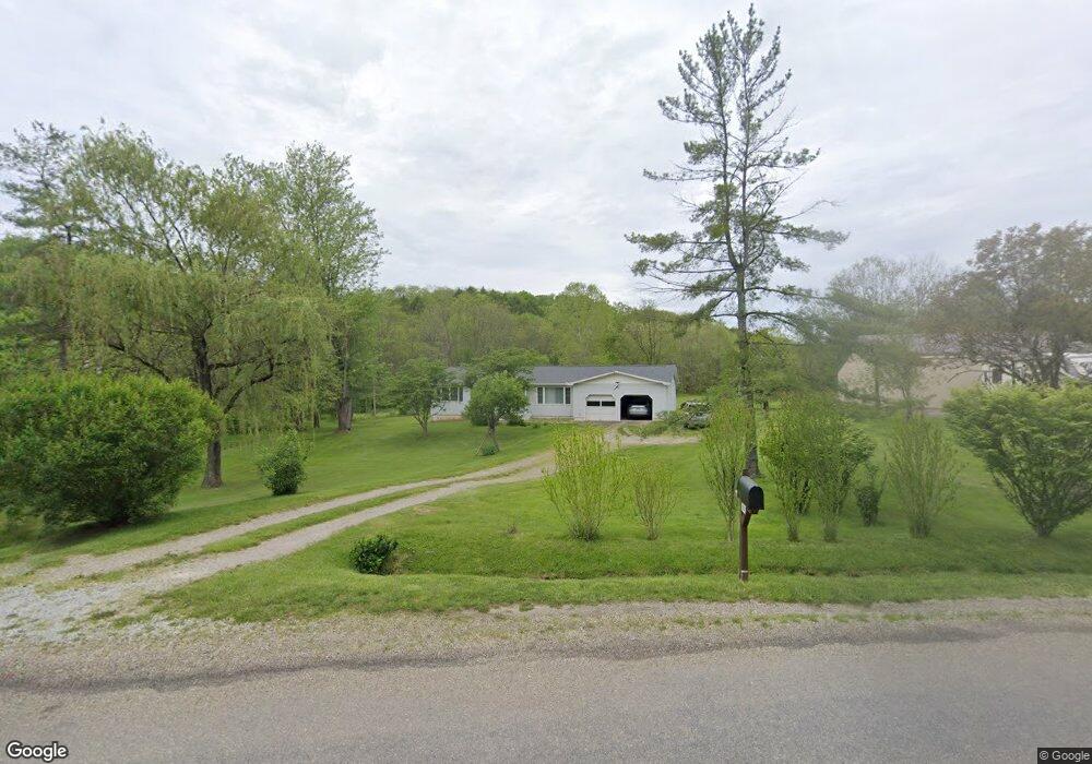
805 Maple Brook Rd New Concord, OH 43762
Estimated Value: $270,000 - $320,000
3
Beds
2
Baths
1,452
Sq Ft
$199/Sq Ft
Est. Value
About This Home
This home is located at 805 Maple Brook Rd, New Concord, OH 43762 and is currently estimated at $288,551, approximately $198 per square foot. 805 Maple Brook Rd is a home located in Muskingum County with nearby schools including New Concord Elementary School, East Muskingum Middle School, and Larry Miller Intermediate Elementary School.
Ownership History
Date
Name
Owned For
Owner Type
Purchase Details
Closed on
Apr 23, 2025
Sold by
Howald Larry J and Howald Kiyoe
Bought by
Howald Larry J and Howald Kiyoe
Current Estimated Value
Create a Home Valuation Report for This Property
The Home Valuation Report is an in-depth analysis detailing your home's value as well as a comparison with similar homes in the area
Home Values in the Area
Average Home Value in this Area
Purchase History
We collect this data history from publicly available records. To have your information removed, we recommend requesting removal directly through your county’s website.
| Date | Buyer | Sale Price | Title Company |
|---|---|---|---|
| Howald Larry J | -- | None Listed On Document | |
| Howald Larry J | -- | None Listed On Document |
Source: Public Records
Tax History
| Year | Tax Paid | Tax Assessment Tax Assessment Total Assessment is a certain percentage of the fair market value that is determined by local assessors to be the total taxable value of land and additions on the property. | Land | Improvement |
|---|---|---|---|---|
| 2025 | $4,187 | $70,770 | $8,505 | $62,265 |
| 2024 | $2,025 | $70,770 | $8,505 | $62,265 |
| 2023 | $1,431 | $49,420 | $5,180 | $44,240 |
| 2022 | $1,418 | $49,420 | $5,180 | $44,240 |
| 2021 | $1,400 | $49,420 | $5,180 | $44,240 |
| 2020 | $1,156 | $41,230 | $4,340 | $36,890 |
| 2019 | $1,150 | $41,230 | $4,340 | $36,890 |
| 2018 | $1,079 | $41,230 | $4,340 | $36,890 |
| 2017 | $960 | $34,475 | $4,340 | $30,135 |
| 2016 | $962 | $34,480 | $4,340 | $30,140 |
| 2015 | $984 | $34,480 | $4,340 | $30,140 |
| 2013 | $1,044 | $34,480 | $4,340 | $30,140 |
Source: Public Records
Map
Nearby Homes
- 470 Nel da Mar Dr
- 825 Friendship Dr
- 212 Westview Dr
- 170 Thompson Ave
- 167 W Main St
- 0 Rix Mills Rd
- 66 W High St
- 177 Lowery Ln
- 110 Cherry Ln
- 245 Liberty Rd
- 135 S Moose Eye Rd
- 10545 Main St
- 60936 Patch Rd
- 101 N Sundale Rd
- 10050 Norwich Dr
- Lot 18 & 19 Greenbriar Dr
- 61220 Kadon Dr
- 60040 Bliss Rd
- 905 W Union Rd
- 3388 Meadow Rd
- 845 Maple Brook Rd
- 755 Maple Brook Rd
- 615 Maple Brook Rd
- 1105 Buck Run Rd
- 1100 Buck Run Rd
- 766 Maple Brook Rd
- 12345 Mckinley Dr
- 0 Maple Brook Rd
- 1165 Maple Brook Rd
- 1080 Tammy Cir
- 1070 Maple Brook Rd
- 1060 Maple Brook Rd
- 12340 Mckinley Dr
- 12330 Mckinley Dr
- 1130 Maple Brook Rd
- 595 Maple Brook Rd
- 1205 Maple Brook Rd
- 2100 Maplebrook Rd
- 12320 Mckinley Dr
- 1055 Tammy Cir
Your Personal Tour Guide
Ask me questions while you tour the home.