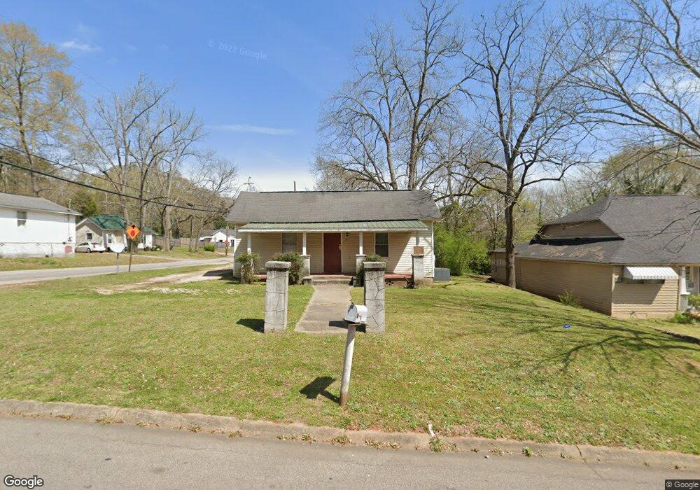
805 Monroe St Lagrange, GA 30240
Estimated Value: $79,000 - $156,000
2
Beds
1
Bath
1,044
Sq Ft
$97/Sq Ft
Est. Value
About This Home
This home is located at 805 Monroe St, Lagrange, GA 30240 and is currently estimated at $101,608, approximately $97 per square foot. 805 Monroe St is a home located in Troup County with nearby schools including Ethel W. Kight Elementary School, Hollis Hand Elementary School, and Franklin Forest Elementary School.
Ownership History
Date
Name
Owned For
Owner Type
Purchase Details
Closed on
Mar 17, 2016
Sold by
David Bradley Rentals Llc
Bought by
Mckeen Garvis G
Current Estimated Value
Purchase Details
Closed on
Sep 28, 2000
Sold by
Thrower Phillip Darrell
Bought by
Perry David Bradley
Purchase Details
Closed on
Jun 22, 1995
Sold by
Jerry Ashmore
Bought by
Thrower Phillip Darrell
Purchase Details
Closed on
Mar 15, 1990
Sold by
Cavender Ralph
Bought by
Jerry Ashmore
Purchase Details
Closed on
Jun 16, 1978
Sold by
Cannon Irene
Bought by
Cavender Ralph
Purchase Details
Closed on
Apr 27, 1978
Sold by
Hale Monroe G
Bought by
Cannon Irene
Create a Home Valuation Report for This Property
The Home Valuation Report is an in-depth analysis detailing your home's value as well as a comparison with similar homes in the area
Purchase History
| Date | Buyer | Sale Price | Title Company |
|---|---|---|---|
| Mckeen Garvis G | $172,975 | -- | |
| Perry David Bradley | $112,000 | -- | |
| Thrower Phillip Darrell | -- | -- | |
| Jerry Ashmore | $12,000 | -- | |
| Cavender Ralph | -- | -- | |
| Cannon Irene | $6,500 | -- |
Source: Public Records
Tax History
| Year | Tax Paid | Tax Assessment Tax Assessment Total Assessment is a certain percentage of the fair market value that is determined by local assessors to be the total taxable value of land and additions on the property. | Land | Improvement |
|---|---|---|---|---|
| 2025 | $470 | $17,240 | $920 | $16,320 |
| 2024 | $404 | $14,800 | $920 | $13,880 |
| 2023 | $359 | $13,160 | $920 | $12,240 |
| 2022 | $347 | $12,440 | $920 | $11,520 |
| 2021 | $253 | $8,400 | $920 | $7,480 |
| 2020 | $253 | $8,400 | $920 | $7,480 |
| 2019 | $234 | $7,760 | $720 | $7,040 |
| 2018 | $234 | $7,760 | $720 | $7,040 |
| 2017 | $209 | $7,760 | $720 | $7,040 |
| 2016 | $233 | $7,723 | $795 | $6,928 |
| 2015 | $388 | $12,835 | $932 | $11,903 |
| 2014 | $318 | $10,506 | $932 | $9,574 |
| 2013 | -- | $11,290 | $932 | $10,358 |
Source: Public Records
Map
Nearby Homes
- 102 Crown St Unit LOT 1
- 101 Crown St Unit LOT 5
- 1518 Brownwood Ave
- 205 Grady St
- 149 Laurel Ridge Ave E
- 120 Laurel Ridge Ave E
- 608 Wilburn Ave
- 610 Wilburn Ave
- 134 Laurel Ridge Ave E
- 109 Garfield St
- 202 Parker Ln
- 167 S Kight Dr
- 107 Clark St
- 211 Moores Hill
- 0 Moores Hill
- 507 S Lee St
- 517 Jefferson St
- 503 S Lee St
- 1304 Forrest Ave
- 1405 Forrest Ave
Your Personal Tour Guide
Ask me questions while you tour the home.