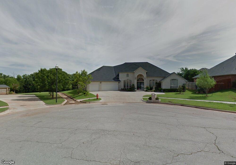
805 NW 153rd Terrace Edmond, OK 73013
Traditions-Ripple Creek NeighborhoodEstimated Value: $512,502 - $583,000
4
Beds
3
Baths
3,493
Sq Ft
$156/Sq Ft
Est. Value
About This Home
This home is located at 805 NW 153rd Terrace, Edmond, OK 73013 and is currently estimated at $544,376, approximately $155 per square foot. 805 NW 153rd Terrace is a home located in Oklahoma County with nearby schools including Charles Haskell Elementary School, Summit Middle School, and Santa Fe High School.
Ownership History
Date
Name
Owned For
Owner Type
Purchase Details
Closed on
Dec 22, 2005
Sold by
Aspen Homes Llc
Bought by
Moses Russell and Moses Antoinette
Current Estimated Value
Home Financials for this Owner
Home Financials are based on the most recent Mortgage that was taken out on this home.
Original Mortgage
$206,000
Outstanding Balance
$115,327
Interest Rate
6.3%
Mortgage Type
Fannie Mae Freddie Mac
Estimated Equity
$429,049
Purchase Details
Closed on
Jun 15, 2005
Sold by
Manchester Homes Llc
Bought by
Aspen Homes Llc
Purchase Details
Closed on
Mar 24, 2005
Sold by
Yang Guang and Cheung Pan
Bought by
Manchester Homes Llc
Purchase Details
Closed on
May 25, 2000
Sold by
Winchester Development Llc
Bought by
Yang Guang
Create a Home Valuation Report for This Property
The Home Valuation Report is an in-depth analysis detailing your home's value as well as a comparison with similar homes in the area
Home Values in the Area
Average Home Value in this Area
Purchase History
| Date | Buyer | Sale Price | Title Company |
|---|---|---|---|
| Moses Russell | $323,000 | First Amer Title & Trust Co | |
| Aspen Homes Llc | $53,000 | -- | |
| Manchester Homes Llc | $52,000 | First American Title & Tr Co | |
| Yang Guang | $46,000 | -- |
Source: Public Records
Mortgage History
| Date | Status | Borrower | Loan Amount |
|---|---|---|---|
| Open | Moses Russell | $206,000 |
Source: Public Records
Tax History Compared to Growth
Tax History
| Year | Tax Paid | Tax Assessment Tax Assessment Total Assessment is a certain percentage of the fair market value that is determined by local assessors to be the total taxable value of land and additions on the property. | Land | Improvement |
|---|---|---|---|---|
| 2024 | $4,973 | $44,065 | $8,320 | $35,745 |
| 2023 | $4,973 | $42,782 | $7,903 | $34,879 |
| 2022 | $4,868 | $41,535 | $9,222 | $32,313 |
| 2021 | $4,675 | $40,326 | $8,446 | $31,880 |
| 2020 | $4,603 | $39,152 | $8,491 | $30,661 |
| 2019 | $4,490 | $38,012 | $8,110 | $29,902 |
| 2018 | $4,383 | $36,905 | $0 | $0 |
| 2017 | $4,480 | $37,926 | $8,601 | $29,325 |
| 2016 | $4,322 | $36,820 | $8,338 | $28,482 |
| 2015 | $4,216 | $35,748 | $8,094 | $27,654 |
| 2014 | $4,079 | $34,707 | $8,295 | $26,412 |
Source: Public Records
Map
Nearby Homes
- 908 NW 157th Terrace
- 600 NW 153rd St
- 15713 Woodleaf Ln
- 15612 Waterstone Way
- 15220 Worthington Ln
- 15605 Waterstone Way
- 15617 Waterstone Way
- 513 NW 154th St
- 15213 Wilford Way
- 15330 Traditions Blvd
- 15505 Park Lake Rd
- 15521 Park Lake Rd
- 508 NW 150th Place
- 15849 Fairview Farm Blvd
- 612 NW 161st St
- 301 NW 153rd St
- 15400 Kestral Park Ct
- 1301 NW 157th St
- 1309 NW 156th Terrace
- 1308 NW 156th Terrace
- 801 NW 153rd Terrace
- 809 NW 153rd Terrace
- 712 NW 153rd St
- 708 NW 153rd St
- 709 NW 153rd Terrace
- 808 NW 153rd Terrace
- 804 NW 153rd Terrace
- 704 NW 153rd St
- 800 NW 153rd Terrace
- 709 NW 153rd St
- 705 NW 153rd Terrace
- 15252 Worthington Ln
- 15248 Worthington Ln
- 708 NW 153rd Terrace
- 705 NW 153rd St
- 700 NW 153rd St
- 15244 Worthington Ln
- 701 NW 153rd St
- 15256 Worthington Ln
- 701 NW 153rd Terrace