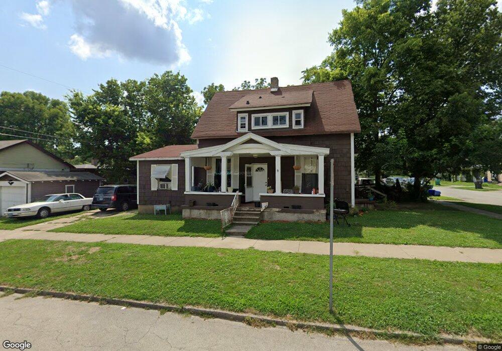
805 W Packard St Decatur, IL 62522
Garfield Park NeighborhoodEstimated Value: $33,000 - $56,000
3
Beds
2
Baths
984
Sq Ft
$45/Sq Ft
Est. Value
About This Home
This home is located at 805 W Packard St, Decatur, IL 62522 and is currently estimated at $44,393, approximately $45 per square foot. 805 W Packard St is a home located in Macon County with nearby schools including Stephen Decatur Middle School, St. Patrick School, and Teen Challenge-Home For Girls.
Ownership History
Date
Name
Owned For
Owner Type
Purchase Details
Closed on
May 16, 2019
Sold by
Ekwity Investments Llc
Bought by
805 W Packard St Trust
Current Estimated Value
Purchase Details
Closed on
Nov 1, 2017
Sold by
Rucker Robert A
Bought by
Ekwity Investments Llc
Purchase Details
Closed on
Aug 19, 2009
Sold by
Martinkins Charles
Bought by
Rucker Robert A
Purchase Details
Closed on
Jun 1, 2007
Sold by
Currin Carolyn A
Bought by
Martinkus Charles A
Purchase Details
Closed on
Mar 1, 2004
Create a Home Valuation Report for This Property
The Home Valuation Report is an in-depth analysis detailing your home's value as well as a comparison with similar homes in the area
Home Values in the Area
Average Home Value in this Area
Purchase History
| Date | Buyer | Sale Price | Title Company |
|---|---|---|---|
| 805 W Packard St Trust | $22,000 | None Available | |
| Ekwity Investments Llc | -- | -- | |
| Rucker Robert A | $60,000 | None Available | |
| Martinkus Charles A | -- | None Available | |
| -- | $20,000 | -- |
Source: Public Records
Tax History Compared to Growth
Tax History
| Year | Tax Paid | Tax Assessment Tax Assessment Total Assessment is a certain percentage of the fair market value that is determined by local assessors to be the total taxable value of land and additions on the property. | Land | Improvement |
|---|---|---|---|---|
| 2024 | $743 | $7,672 | $436 | $7,236 |
| 2023 | $737 | $7,401 | $421 | $6,980 |
| 2022 | $714 | $6,980 | $389 | $6,591 |
| 2021 | $671 | $6,519 | $364 | $6,155 |
| 2020 | $661 | $6,217 | $348 | $5,869 |
| 2019 | $661 | $6,217 | $348 | $5,869 |
| 2018 | $701 | $6,670 | $128 | $6,542 |
| 2017 | $717 | $6,848 | $131 | $6,717 |
| 2016 | $731 | $6,918 | $132 | $6,786 |
| 2015 | $695 | $6,796 | $130 | $6,666 |
| 2014 | $588 | $6,138 | $176 | $5,962 |
| 2013 | $608 | $6,369 | $183 | $6,186 |
Source: Public Records
Map
Nearby Homes
- 837 W Grand Ave
- 875 N Monroe St
- 844 N Edward St
- 415 W Green St
- 1545 N Monroe St
- 1245 N Union St
- 1504 N Monroe St
- 1065 W Green St
- 644 W Division St
- 933 W Division St
- 1653 N Maple Ave
- 1458 N Union St
- 925 W Olive St
- 141 E Packard St
- 917 N Wilder Ave
- 958 W William St
- 254 N Pine St
- 609 W William St
- 422 W William St
- 330 W William St
- 817 W Packard St
- 819 W Packard St
- 806 W Elm St
- 810 W Elm St
- 1050 N Pine St
- 755 W Packard St
- 806 W Packard St
- 825 W Packard St
- 826 W Elm St
- 1042 N Pine St
- 760 W Packard St
- 841 W Packard St
- 735 W Packard St
- 820 W Packard St
- 815 W Elm St
- 805 W Elm St
- 836 W Elm St
- 1032 N Pine St
- 828 W Packard St
- 736 W Packard St