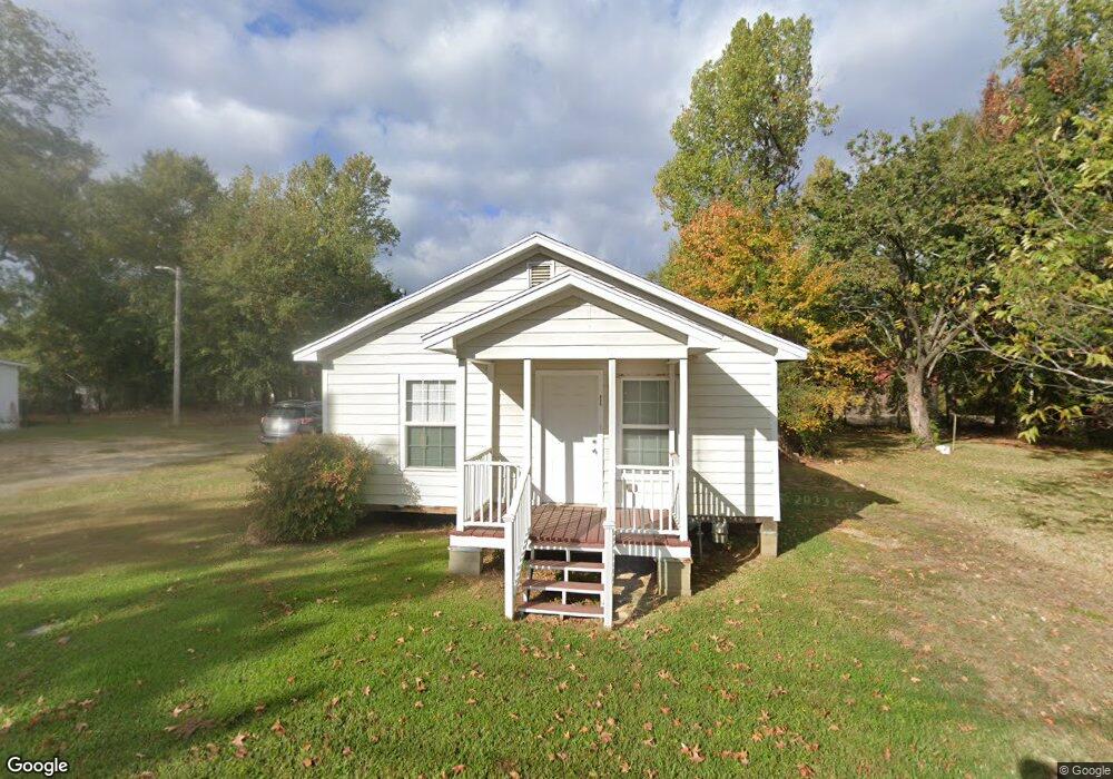
806 Lewis St Ruston, LA 71270
Estimated Value: $58,310 - $166,000
Studio
--
Bath
768
Sq Ft
$129/Sq Ft
Est. Value
About This Home
This home is located at 806 Lewis St, Ruston, LA 71270 and is currently estimated at $99,437, approximately $129 per square foot. 806 Lewis St is a home located in Lincoln Parish with nearby schools including Ruston Elementary School, Hillcrest Elementary School, and Ruston Junior High School.
Ownership History
Date
Name
Owned For
Owner Type
Purchase Details
Closed on
Jun 17, 2013
Sold by
Lewis Ronnie W
Bought by
Professional Property Investors Llc
Current Estimated Value
Purchase Details
Closed on
Jul 1, 2006
Sold by
Lewis Claude B and Roane Christine Lewis
Bought by
Lewis Ronnie W
Create a Home Valuation Report for This Property
The Home Valuation Report is an in-depth analysis detailing your home's value as well as a comparison with similar homes in the area
Purchase History
| Date | Buyer | Sale Price | Title Company |
|---|---|---|---|
| Professional Property Investors Llc | -- | None Available | |
| Lewis Ronnie W | -- | None Available |
Source: Public Records
Tax History
| Year | Tax Paid | Tax Assessment Tax Assessment Total Assessment is a certain percentage of the fair market value that is determined by local assessors to be the total taxable value of land and additions on the property. | Land | Improvement |
|---|---|---|---|---|
| 2025 | $305 | $3,573 | $372 | $3,201 |
| 2024 | $305 | $3,573 | $372 | $3,201 |
| 2023 | $300 | $3,374 | $217 | $3,157 |
| 2022 | $301 | $3,374 | $217 | $3,157 |
| 2021 | $279 | $3,374 | $217 | $3,157 |
| 2020 | $266 | $3,203 | $248 | $2,955 |
| 2019 | $260 | $3,203 | $248 | $2,955 |
| 2018 | $253 | $3,203 | $248 | $2,955 |
| 2017 | $254 | $3,203 | $248 | $2,955 |
| 2016 | $253 | $0 | $0 | $0 |
| 2015 | $229 | $2,666 | $248 | $2,418 |
| 2013 | $233 | $2,666 | $248 | $2,418 |
Source: Public Records
Map
Nearby Homes
- 000 Eastland Ave
- 1401 Wyoming Ave
- 900 Cornell Ave
- 1304 Lewis St
- 1200 E Mississippi Ave
- 102 Calvin Ave Unit 707 S Farmerville St
- 911 S Farmerville St
- 1203 Kenwood Dr
- 509 2nd Ave
- 108 S Farmerville St
- 322 N Bernard St
- 145 Clearwater Cir
- 000 Louisiana 33
- 14 Moores Dairy Rd
- 08 Moores Dairy Rd
- 10 Moores Dairy Rd
- 16 Moores Dairy Rd
- 12 Moores Dairy Rd
- 203 E California Ave
- 716 Jody Ct
Your Personal Tour Guide
Ask me questions while you tour the home.