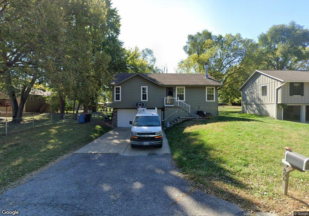
806 W Oak Street West N A Greenwood, MO 64034
Estimated Value: $232,000 - $306,000
2
Beds
2
Baths
1,026
Sq Ft
$258/Sq Ft
Est. Value
About This Home
This home is located at 806 W Oak Street West N A, Greenwood, MO 64034 and is currently estimated at $264,235, approximately $257 per square foot. 806 W Oak Street West N A is a home located in Jackson County with nearby schools including Greenwood Elementary School, Summit Lakes Middle School, and Lee's Summit West High School.
Ownership History
Date
Name
Owned For
Owner Type
Purchase Details
Closed on
Jun 10, 2016
Sold by
Gohdes Matthew C and Gohdes Andrea M
Bought by
Tolle Donald Anthony and Tolle Melissa Sue
Current Estimated Value
Home Financials for this Owner
Home Financials are based on the most recent Mortgage that was taken out on this home.
Original Mortgage
$111,935
Outstanding Balance
$89,204
Interest Rate
3.61%
Mortgage Type
FHA
Estimated Equity
$175,031
Purchase Details
Closed on
Oct 27, 2009
Sold by
Gohdes Matthew C and Gohdes Andrea M
Bought by
Gohdes Matthew C and Gohdes Andrea M
Home Financials for this Owner
Home Financials are based on the most recent Mortgage that was taken out on this home.
Original Mortgage
$105,820
Interest Rate
5.03%
Mortgage Type
FHA
Purchase Details
Closed on
Jan 2, 2004
Sold by
Ponder Deborah M
Bought by
Gohdes Matthew C and Brown Andrea M
Home Financials for this Owner
Home Financials are based on the most recent Mortgage that was taken out on this home.
Original Mortgage
$103,550
Interest Rate
5.84%
Mortgage Type
Purchase Money Mortgage
Purchase Details
Closed on
Jul 26, 2001
Sold by
Ponder Johnnie E
Bought by
Ponder Deborah M
Home Financials for this Owner
Home Financials are based on the most recent Mortgage that was taken out on this home.
Original Mortgage
$85,500
Interest Rate
7.05%
Mortgage Type
Purchase Money Mortgage
Purchase Details
Closed on
Jan 19, 2001
Sold by
Wingfield Brent L and Curtis Wingfield Gayla Danne
Bought by
Ponder Johnnie E and Ponder Deborah M
Home Financials for this Owner
Home Financials are based on the most recent Mortgage that was taken out on this home.
Original Mortgage
$85,400
Interest Rate
7.43%
Mortgage Type
Purchase Money Mortgage
Purchase Details
Closed on
Feb 14, 1997
Sold by
Allen Yong Ho and Allen Chu S
Bought by
Wingfield Brent L
Home Financials for this Owner
Home Financials are based on the most recent Mortgage that was taken out on this home.
Original Mortgage
$77,393
Interest Rate
7.92%
Mortgage Type
FHA
Create a Home Valuation Report for This Property
The Home Valuation Report is an in-depth analysis detailing your home's value as well as a comparison with similar homes in the area
Home Values in the Area
Average Home Value in this Area
Purchase History
| Date | Buyer | Sale Price | Title Company |
|---|---|---|---|
| Tolle Donald Anthony | -- | Alpha Title | |
| Gohdes Matthew C | -- | Midwest Title Company Inc | |
| Gohdes Matthew C | -- | Ctic | |
| Ponder Deborah M | -- | Security Land Title Company | |
| Ponder Johnnie E | -- | Security Land Title Co | |
| Wingfield Brent L | -- | -- |
Source: Public Records
Mortgage History
| Date | Status | Borrower | Loan Amount |
|---|---|---|---|
| Open | Tolle Donald Anthony | $111,935 | |
| Previous Owner | Gohdes Matthew C | $105,820 | |
| Previous Owner | Gohdes Matthew C | $103,550 | |
| Previous Owner | Ponder Deborah M | $85,500 | |
| Previous Owner | Ponder Johnnie E | $85,400 | |
| Previous Owner | Wingfield Brent L | $77,393 |
Source: Public Records
Tax History Compared to Growth
Tax History
| Year | Tax Paid | Tax Assessment Tax Assessment Total Assessment is a certain percentage of the fair market value that is determined by local assessors to be the total taxable value of land and additions on the property. | Land | Improvement |
|---|---|---|---|---|
| 2025 | $2,109 | $33,168 | $5,546 | $27,622 |
| 2024 | $2,088 | $30,508 | $4,247 | $26,261 |
| 2023 | $2,088 | $30,509 | $2,837 | $27,672 |
| 2022 | $1,949 | $25,080 | $3,484 | $21,596 |
| 2021 | $1,994 | $25,080 | $3,484 | $21,596 |
| 2020 | $1,926 | $23,825 | $3,484 | $20,341 |
| 2019 | $1,892 | $23,825 | $3,484 | $20,341 |
| 2018 | $1,779 | $20,735 | $3,032 | $17,703 |
| 2017 | $1,779 | $20,735 | $3,032 | $17,703 |
| 2016 | $1,779 | $20,216 | $722 | $19,494 |
| 2014 | $1,749 | $19,416 | $672 | $18,744 |
Source: Public Records
Map
Nearby Homes
- 202 6th Ave S
- 1106 Huntington Ln
- 1107 Huntington Ln
- 1210 Huntington Ln
- 701 16th Ave S
- 105 17th Ave S
- 405 17th Ave S
- 403 Ridgeway Dr
- 704 16th Ave S
- 1301 Meadows Ln
- 1900 Blackfoot Ct
- 1803 Brent Ln
- 1104 16th Ave S
- 202 20th Ave S
- 1306 Dogwood Dr
- 810 Tabitha Ln
- 1208 Bradford Dr
- 1904 Gambrell St
- 1505 Rolling Dr
- 206 20th Ave N