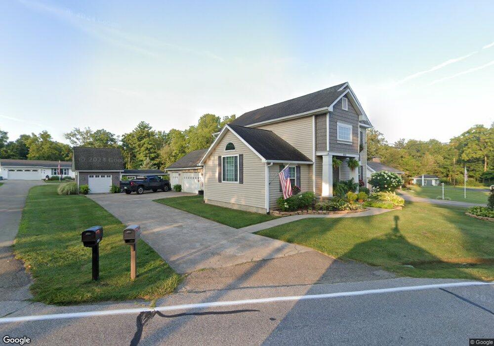
8069 Forest Rd Cincinnati, OH 45255
Estimated Value: $327,693 - $427,000
3
Beds
2
Baths
2,147
Sq Ft
$175/Sq Ft
Est. Value
About This Home
This home is located at 8069 Forest Rd, Cincinnati, OH 45255 and is currently estimated at $375,923, approximately $175 per square foot. 8069 Forest Rd is a home located in Hamilton County with nearby schools including Ayer Elementary School, Nagel Middle School, and Anderson High School.
Ownership History
Date
Name
Owned For
Owner Type
Purchase Details
Closed on
Dec 18, 2013
Sold by
Weaver Kristina Elaine and Weaver Anthony James
Bought by
Weaver Anthony James
Current Estimated Value
Purchase Details
Closed on
Jul 27, 2006
Sold by
Weaver Robert J and Weaver Martha J
Bought by
Weaver Anthony James and Weaver Kristina Elaine
Home Financials for this Owner
Home Financials are based on the most recent Mortgage that was taken out on this home.
Original Mortgage
$103,700
Interest Rate
6.83%
Mortgage Type
Unknown
Purchase Details
Closed on
Dec 31, 2002
Sold by
Weaver Robert J and Weaver Martha J
Bought by
Weaver Anthony James and Weaver Kristina Elaine
Purchase Details
Closed on
Dec 20, 1999
Sold by
Weaver Robert J and Weaver Martha J
Bought by
Weaver Robert J and Weaver Martha J
Create a Home Valuation Report for This Property
The Home Valuation Report is an in-depth analysis detailing your home's value as well as a comparison with similar homes in the area
Home Values in the Area
Average Home Value in this Area
Purchase History
| Date | Buyer | Sale Price | Title Company |
|---|---|---|---|
| Weaver Anthony James | -- | Attorney | |
| Weaver Anthony James | -- | None Available | |
| Weaver Anthony James | -- | -- | |
| Weaver Robert J | -- | -- |
Source: Public Records
Mortgage History
| Date | Status | Borrower | Loan Amount |
|---|---|---|---|
| Closed | Weaver Anthony James | $103,700 |
Source: Public Records
Tax History
| Year | Tax Paid | Tax Assessment Tax Assessment Total Assessment is a certain percentage of the fair market value that is determined by local assessors to be the total taxable value of land and additions on the property. | Land | Improvement |
|---|---|---|---|---|
| 2025 | $5,609 | $89,527 | $13,608 | $75,919 |
| 2023 | $5,188 | $89,527 | $13,608 | $75,919 |
| 2022 | $3,803 | $58,377 | $10,983 | $47,394 |
| 2021 | $3,718 | $58,377 | $10,983 | $47,394 |
| 2020 | $3,755 | $58,377 | $10,983 | $47,394 |
| 2019 | $3,662 | $51,661 | $9,720 | $41,941 |
| 2018 | $3,432 | $51,661 | $9,720 | $41,941 |
| 2017 | $3,240 | $51,661 | $9,720 | $41,941 |
| 2016 | $3,008 | $46,785 | $9,720 | $37,065 |
| 2015 | $2,920 | $46,785 | $9,720 | $37,065 |
| 2014 | $2,921 | $46,785 | $9,720 | $37,065 |
| 2013 | $2,710 | $45,868 | $9,531 | $36,337 |
Source: Public Records
Map
Nearby Homes
- 937 Merritt Grove Ln
- 1013 Wittshire Ln
- 7926 Causeway Ln
- 1073 Wittshire Cir Unit 113
- 8016 Hignite Ct
- 1125 Wittshire Ln Unit 130
- 8372 Benton Ridge Ln
- 8303 Tidewater Ct
- 881 Asbury Rd
- 1054 Eight Mile Rd
- 7754 Forest Rd
- 7978 Nagel Village Dr
- 8345 Cherry Ln
- 1251 Eight Mile Rd
- 1357 Oak Ct
- 1363 Oak Ct
- 8096 Pineterrace Dr
- 1400 Sigma Cir
- 1333 Eight Mile Rd
- 8022 Stonegate Dr
- 8057 Forest Rd
- 8081 Forest Rd
- 8073 Forest Rd
- 8047 Forest Rd
- 8074 Forest Rd
- 8086 Forest Rd
- 8100 Forest Rd
- 8101 Forest Rd
- 8039 Forest Rd
- 8110 Forest Rd
- 8046 Forest Rd
- 8087 Forest Rd
- 8034 Forest Rd
- 909 Merritt Grove Ln
- 8115 Forest Rd
- 921 Merritt Grove Ln
- 8107 Forest Rd
- 929 Merritt Grove Ln
- 8594 Forest Rd
- 862 Ackley Rd
Your Personal Tour Guide
Ask me questions while you tour the home.