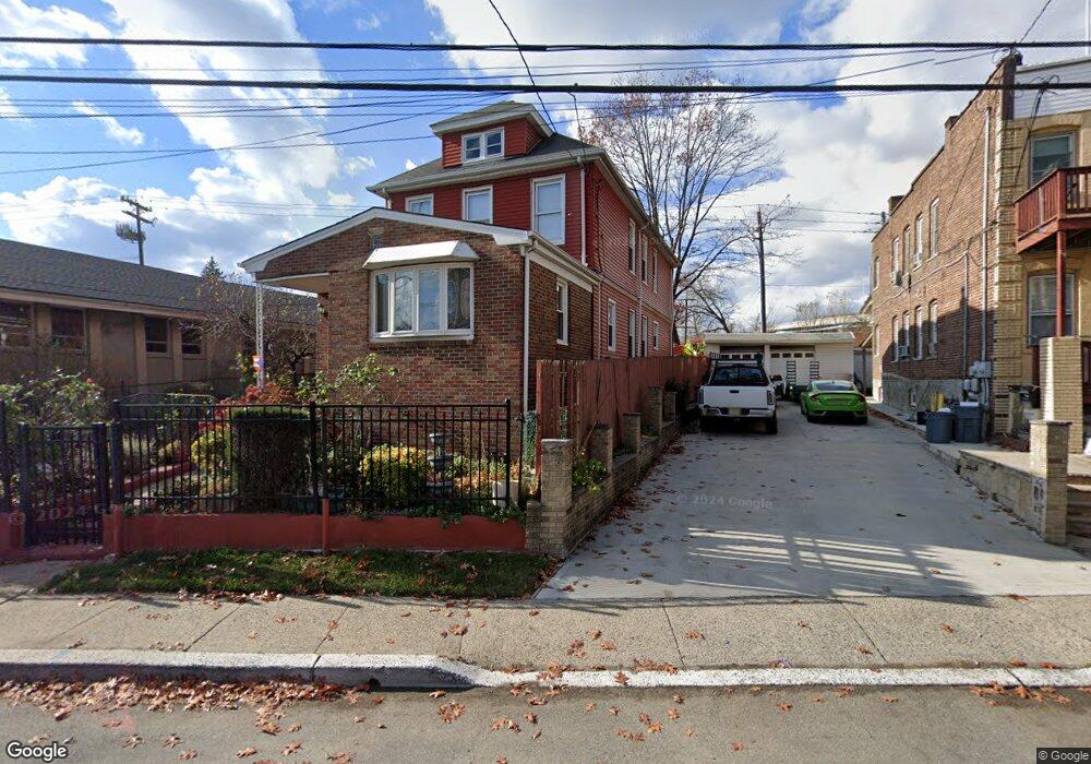
807 State St Perth Amboy, NJ 08861
Hall Avenue NeighborhoodEstimated Value: $510,829 - $570,000
--
Bed
--
Bath
1,880
Sq Ft
$287/Sq Ft
Est. Value
About This Home
This home is located at 807 State St, Perth Amboy, NJ 08861 and is currently estimated at $539,457, approximately $286 per square foot. 807 State St is a home located in Middlesex County with nearby schools including Perth Amboy High School, Academy for Urban Leadership Charter School, and Assumption Catholic School.
Ownership History
Date
Name
Owned For
Owner Type
Purchase Details
Closed on
Oct 12, 2018
Sold by
Arocho Amaury
Bought by
Patino Ubaldo and Patino Brenda
Current Estimated Value
Home Financials for this Owner
Home Financials are based on the most recent Mortgage that was taken out on this home.
Original Mortgage
$284,747
Interest Rate
4.9%
Mortgage Type
FHA
Purchase Details
Closed on
Dec 8, 2008
Sold by
Us Bank National Association
Bought by
Arocho Amaury
Home Financials for this Owner
Home Financials are based on the most recent Mortgage that was taken out on this home.
Original Mortgage
$193,325
Interest Rate
5.25%
Mortgage Type
Seller Take Back
Purchase Details
Closed on
Apr 9, 2008
Sold by
Negron Carmelita and Cardona Sergio
Bought by
Us Bank Na and Structured Asset Investment Loan Trust 2
Create a Home Valuation Report for This Property
The Home Valuation Report is an in-depth analysis detailing your home's value as well as a comparison with similar homes in the area
Home Values in the Area
Average Home Value in this Area
Purchase History
| Date | Buyer | Sale Price | Title Company |
|---|---|---|---|
| Patino Ubaldo | $290,000 | New Horizon Abstract Inc | |
| Arocho Amaury | $197,000 | River Edge Title Agency Llc | |
| Us Bank Na | $301,252 | Land Title Svcs Of Nj Inc |
Source: Public Records
Mortgage History
| Date | Status | Borrower | Loan Amount |
|---|---|---|---|
| Previous Owner | Patino Ubaldo | $284,747 | |
| Previous Owner | Arocho Amaury | $193,325 |
Source: Public Records
Tax History Compared to Growth
Tax History
| Year | Tax Paid | Tax Assessment Tax Assessment Total Assessment is a certain percentage of the fair market value that is determined by local assessors to be the total taxable value of land and additions on the property. | Land | Improvement |
|---|---|---|---|---|
| 2025 | $8,375 | $277,600 | $79,700 | $197,900 |
| 2024 | $8,359 | $277,600 | $79,700 | $197,900 |
| 2023 | $8,359 | $277,600 | $79,700 | $197,900 |
| 2022 | $8,259 | $277,600 | $79,700 | $197,900 |
| 2021 | $8,270 | $277,600 | $79,700 | $197,900 |
| 2020 | $8,267 | $277,600 | $79,700 | $197,900 |
| 2019 | $8,297 | $277,600 | $71,700 | $205,900 |
| 2018 | $8,225 | $277,600 | $71,700 | $205,900 |
| 2017 | $8,209 | $277,600 | $71,700 | $205,900 |
| 2016 | $7,995 | $277,600 | $71,700 | $205,900 |
| 2015 | $8,050 | $277,600 | $71,700 | $205,900 |
| 2014 | $8,100 | $277,600 | $71,700 | $205,900 |
Source: Public Records
Map
Nearby Homes
- 278 Alpine St
- 168 Lynd St
- 335 Alpine St
- 680 Charles St
- 381 Keene St
- 676 Johnstone St
- 212 Hall Ave
- 270 Hall Ave
- 646 Johnstone St
- 816 Harbortown Blvd
- 434 Lawrence St Unit 19
- 794 Harbortown Blvd
- 435 Ashley St
- 519 W Side Ave
- 500 Great Beds Ct
- 522 Johnstone St
- 649 Cornell St
- 142 William St
- 359 Neville St
- 514 S Park Dr