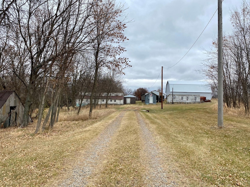
8071 70th St W Lonsdale, MN 55046
Estimated payment $4,982/month
Highlights
- Corner Lot
- Greenbelt
- Conservation Reserve Program Land
- No HOA
- Many Trees
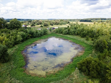
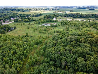
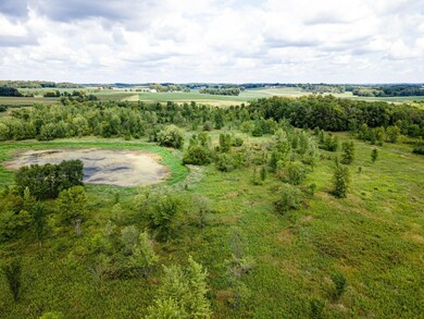
About This Lot
Currently zoned agriculture, this 66.57 acreage property north of town is situated in a great location!
55 acres in CRP, heavily wooded with low rolling terrain throughout. Under the city's Comprehensive 2040 plan, this land is marked for low density development. In the street are underground utilities of gas, sewer and water are available for hook-up, giving easy access for future growth. For further land use and
development, call the city of Lonsdale.
Property Details
Property Type
- Land
Est. Annual Taxes
- $2,872
Lot Details
- Conservation Reserve Program Land
- Corner Lot
- Many Trees
- Zoning described as Agriculture
Community Details
- No Home Owners Association
- Greenbelt
Listing and Financial Details
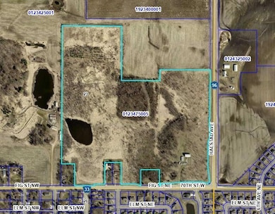
- Assessor Parcel Number 0123475005
Map
Home Values in the Area
Average Home Value in this Area
Tax History
| Year | Tax Paid | Tax Assessment Tax Assessment Total Assessment is a certain percentage of the fair market value that is determined by local assessors to be the total taxable value of land and additions on the property. | Land | Improvement |
|---|---|---|---|---|
| 2025 | $2,872 | $510,300 | $503,400 | $6,900 |
| 2024 | $2,872 | $436,100 | $429,800 | $6,300 |
| 2023 | $2,714 | $436,100 | $429,800 | $6,300 |
| 2022 | $2,764 | $428,500 | $422,800 | $5,700 |
| 2021 | $2,874 | $377,900 | $372,800 | $5,100 |
| 2020 | $3,090 | $377,700 | $372,800 | $4,900 |
| 2019 | $3,144 | $400,000 | $395,100 | $4,900 |
| 2018 | $3,046 | $377,700 | $372,800 | $4,900 |
| 2017 | $3,496 | $377,300 | $372,800 | $4,500 |
| 2016 | $3,798 | $377,300 | $372,800 | $4,500 |
| 2015 | $3,794 | $377,300 | $372,800 | $4,500 |
| 2014 | -- | $377,300 | $372,800 | $4,500 |
Property History
| Date | Event | Price | List to Sale | Price per Sq Ft |
|---|---|---|---|---|
| 11/07/2025 11/07/25 | For Sale | $899,900 | -- | -- |
Source: NorthstarMLS
MLS Number: 6815165
APN: 01.23.4.75.005
Disclaimer: Certain information contained herein is derived from information provided by parties other than Homes.com. All information provided is deemed reliable, but is not guaranteed to be accurate and should be independently verified.
![]() Based on information submitted to the MLS GRID. All data is obtained from various sources and may not have been verified by broker or MLS GRID. Supplied Open House Information is subject to change without notice. All information should be independently reviewed and verified for accuracy. Properties may or may not be listed by the office/agent presenting the information. Some IDX listings have been excluded from this website.
Based on information submitted to the MLS GRID. All data is obtained from various sources and may not have been verified by broker or MLS GRID. Supplied Open House Information is subject to change without notice. All information should be independently reviewed and verified for accuracy. Properties may or may not be listed by the office/agent presenting the information. Some IDX listings have been excluded from this website.
The Digital Millennium Copyright Act of 1998, 17 U.S.C. § 512 (the “DMCA”) provides recourse for copyright owners who believe that material appearing on the Internet infringes their rights under U.S. copyright law. If you believe in good faith that any content or material made available in connection with our website or services infringes your copyright, you (or your agent) may send us a notice requesting that the content or material be removed, or access to it blocked.
Notices must be sent in writing by email to DMCAnotice@MLSGrid.com.
The DMCA requires that your notice of alleged copyright infringement include the following information:
(1) description of the copyrighted work that is the subject of claimed infringement;
(2) description of the alleged infringing content and information sufficient to permit us to locate the content;
(3) contact information for you, including your address, telephone number and email address;
(4) a statement by you that you have a good faith belief that the content in the manner complained of is not authorized by the copyright owner, or its agent, or by the operation of any law;
(5) a statement by you, signed under penalty of perjury, that the information in the notification is accurate and that you have the authority to enforce the copyrights that are claimed to be infringed; and
(6) a physical or electronic signature of the copyright owner or a person authorized to act on the copyright owner’s behalf. Failure to include all of the above information may result in the delay of the processing of your complaint.
- Fig & 96 Halstad Ave
- 210 Dogwood St NE
- 703 8th Ave NE
- Cnty 96&Fig Cnty Road 96
- 420 Birch St NE
- 814 Hickory St NE
- 727 Birch St NE
- 427 11th Ave NE
- 6550 Halstad Ave
- 133 Ash St NW
- 527 4th Circle Dr SE
- 451 Delaware St SW
- 536 5th Ave SW
- 236 Hawaii St SE
- 415 8th Ave SW
- XXXX Commerce Dr SE
- The Calhoun Plan at Harmony Meadows
- The Springfield Plan at Harmony Meadows
- The Arlington Plan at Harmony Meadows
- The Wentworth Plan at Harmony Meadows
- 220 Old Town Rd
- 102 Chalupsky Ave SE
- 1200 4th St NE
- 1008 3rd St NE
- 617 2nd St NW
- 80 West Ave W
- 2411-2431 Jefferson Rd
- 2005 Jefferson Rd
- 1400 Heritage Dr
- 1370 Heritage Dr
- 11656 207th St W
- 801 Kraewood Dr
- 1900-1960 Roosevelt Dr
- 500 Woodley St W
- 710-740 N Highway 3
- 116 5th St E
- 21354 Idaho Ave
- 8500 210th St W
- 20390 Dodd Blvd
- 20660 Holyoke Ave Unit 2
