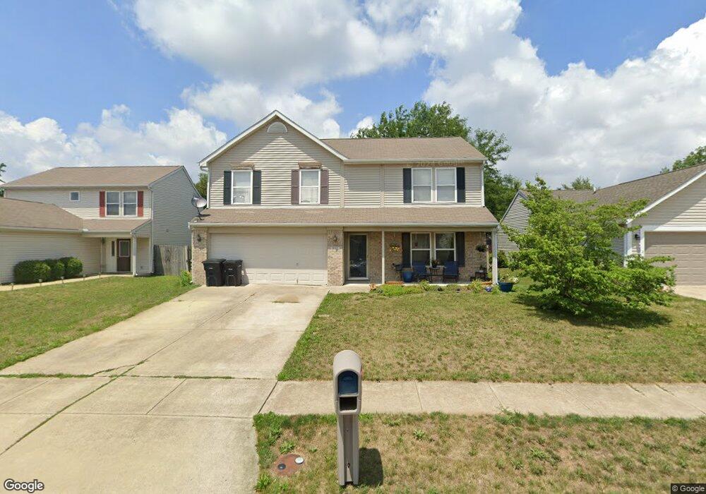
808 Braxton Dr N Lafayette, IN 47909
Estimated Value: $251,980 - $300,000
--
Bed
1
Bath
1,920
Sq Ft
$147/Sq Ft
Est. Value
About This Home
This home is located at 808 Braxton Dr N, Lafayette, IN 47909 and is currently estimated at $282,495, approximately $147 per square foot. 808 Braxton Dr N is a home located in Tippecanoe County with nearby schools including Wea Ridge Elementary School, Wea Ridge Middle School, and McCutcheon High School.
Ownership History
Date
Name
Owned For
Owner Type
Purchase Details
Closed on
Aug 28, 2001
Sold by
Crossmann Communities Partnership
Bought by
Webb Douglas D and Webb Kara J
Current Estimated Value
Home Financials for this Owner
Home Financials are based on the most recent Mortgage that was taken out on this home.
Original Mortgage
$115,000
Outstanding Balance
$45,236
Interest Rate
7.11%
Estimated Equity
$237,259
Purchase Details
Closed on
Jun 15, 2001
Sold by
Saddlebrook Development Llc
Bought by
Crossmann Communities Partnership
Create a Home Valuation Report for This Property
The Home Valuation Report is an in-depth analysis detailing your home's value as well as a comparison with similar homes in the area
Home Values in the Area
Average Home Value in this Area
Purchase History
| Date | Buyer | Sale Price | Title Company |
|---|---|---|---|
| Webb Douglas D | -- | -- | |
| Crossmann Communities Partnership | -- | -- |
Source: Public Records
Mortgage History
| Date | Status | Borrower | Loan Amount |
|---|---|---|---|
| Open | Webb Douglas D | $115,000 |
Source: Public Records
Tax History Compared to Growth
Tax History
| Year | Tax Paid | Tax Assessment Tax Assessment Total Assessment is a certain percentage of the fair market value that is determined by local assessors to be the total taxable value of land and additions on the property. | Land | Improvement |
|---|---|---|---|---|
| 2024 | $2,248 | $224,800 | $16,000 | $208,800 |
| 2023 | $2,092 | $206,900 | $16,000 | $190,900 |
| 2022 | $1,847 | $186,100 | $16,000 | $170,100 |
| 2021 | $1,597 | $161,100 | $16,000 | $145,100 |
| 2020 | $1,482 | $149,600 | $16,000 | $133,600 |
| 2019 | $1,333 | $139,700 | $16,000 | $123,700 |
| 2018 | $1,213 | $133,300 | $16,000 | $117,300 |
| 2017 | $1,176 | $129,400 | $16,000 | $113,400 |
| 2016 | $1,118 | $127,700 | $16,000 | $111,700 |
| 2014 | $1,031 | $123,900 | $16,000 | $107,900 |
| 2013 | $943 | $116,000 | $12,000 | $104,000 |
Source: Public Records
Map
Nearby Homes
- 4101 Lofton Dr
- 934 Ravenstone Dr
- 920 N Wagon Wheel Trail
- 8151 John Adams Rd
- 8165 John Adams Rd
- 8171 John Adams Rd
- 8157 John Adams Rd
- TBD John Adams Rd
- 3906 John Adams Rd
- 1120 Stoneripple Cir
- 1007 Waterstone Dr
- 51 Brookberry Dr
- 936 Brookridge Ct
- 12 Brookhill Ct
- 214 Mccutcheon Dr
- 90 Mayflower Ct
- 1817 Kingfisher Dr
- 4108 Westwind Dr
- 1821 Whisper Valley Dr
- 3638 Round Rock Ct
- 812 Braxton Dr N
- 804 Braxton Dr N
- 800 Braxton Dr N
- 816 Braxton Dr N
- 813 Braxton Dr N
- 809 Braxton Dr N
- 718 Braxton Dr N
- 805 Braxton Dr N
- 820 Braxton Dr N
- 801 Braxton Dr N
- 817 Braxton Dr N
- 714 Braxton Dr N
- 824 Braxton Dr N
- 719 Braxton Dr N
- 821 Braxton Dr N
- 810 Harrington Dr
- 814 Harrington Dr
- 806 Harrington Dr
- 715 Braxton Dr N
- 825 Braxton Dr N