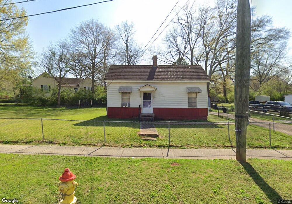
808 Dunson St Lagrange, GA 30240
Estimated Value: $72,000 - $84,000
2
Beds
1
Bath
836
Sq Ft
$93/Sq Ft
Est. Value
About This Home
This home is located at 808 Dunson St, Lagrange, GA 30240 and is currently estimated at $77,451, approximately $92 per square foot. 808 Dunson St is a home located in Troup County with nearby schools including Berta Weathersbee Elementary School, Whitesville Road Elementary School, and Rosemont Elementary School.
Ownership History
Date
Name
Owned For
Owner Type
Purchase Details
Closed on
Oct 10, 2000
Sold by
Keeble Margaret H
Bought by
Harris Beverly and Hart Willie
Current Estimated Value
Purchase Details
Closed on
Mar 1, 1995
Sold by
Alton B Bailey
Bought by
Keeble Margaret H
Purchase Details
Closed on
Jun 21, 1977
Sold by
Catherine Morelan M and Catherine Mobley
Bought by
Alton B Bailey
Purchase Details
Closed on
May 14, 1977
Sold by
Cantrell Armenda and Cantrell Walter C
Bought by
Catherine Morelan M and Catherine Mobley
Purchase Details
Closed on
Jan 1, 1971
Sold by
Mcdonald Dovie Butler Bearden
Bought by
Cantrell Armenda and Cantrell Walter C
Purchase Details
Closed on
Jan 1, 1952
Sold by
Butler Dovie B No Deed Bk & Pg
Bought by
Mcdonald Dovie Butler Bearden
Create a Home Valuation Report for This Property
The Home Valuation Report is an in-depth analysis detailing your home's value as well as a comparison with similar homes in the area
Purchase History
| Date | Buyer | Sale Price | Title Company |
|---|---|---|---|
| Harris Beverly | $33,000 | -- | |
| Keeble Margaret H | $74,000 | -- | |
| Alton B Bailey | $1,300 | -- | |
| Catherine Morelan M | $11,500 | -- | |
| Cantrell Armenda | -- | -- | |
| Mcdonald Dovie Butler Bearden | -- | -- |
Source: Public Records
Tax History
| Year | Tax Paid | Tax Assessment Tax Assessment Total Assessment is a certain percentage of the fair market value that is determined by local assessors to be the total taxable value of land and additions on the property. | Land | Improvement |
|---|---|---|---|---|
| 2025 | $447 | $18,744 | $2,520 | $16,224 |
| 2024 | $427 | $17,628 | $2,520 | $15,108 |
| 2023 | $2 | $15,508 | $2,520 | $12,988 |
| 2022 | $358 | $14,828 | $2,520 | $12,308 |
| 2021 | $260 | $10,596 | $2,520 | $8,076 |
| 2020 | $260 | $10,596 | $2,520 | $8,076 |
| 2019 | $234 | $9,740 | $2,520 | $7,220 |
| 2018 | $235 | $9,780 | $2,560 | $7,220 |
| 2017 | $235 | $9,780 | $2,560 | $7,220 |
| 2016 | $234 | $9,750 | $2,560 | $7,190 |
| 2015 | $235 | $9,750 | $2,560 | $7,190 |
| 2014 | $192 | $8,315 | $2,560 | $5,755 |
| 2013 | -- | $8,712 | $2,560 | $6,152 |
Source: Public Records
Map
Nearby Homes
- 914 Todd St
- 1186 Lindsey St
- 501 Milam St
- 606 Poplar St
- 101 Cedar St
- 206 Peachtree St
- 103 Cedar St
- 112 Cedar St
- 207 Wilkes St
- 1191 Whitesville St
- 0 Bagley St
- 1300 Murphy Ave
- 303 E Mulberry St
- 109 Bell St
- 600 Park Ave
- 812 Elm St
- 1205 Park Ave
- 1201 Whitesville St
- 0 Boggs St Unit 10550243
- 0 Boggs St Unit 10550231
Your Personal Tour Guide
Ask me questions while you tour the home.