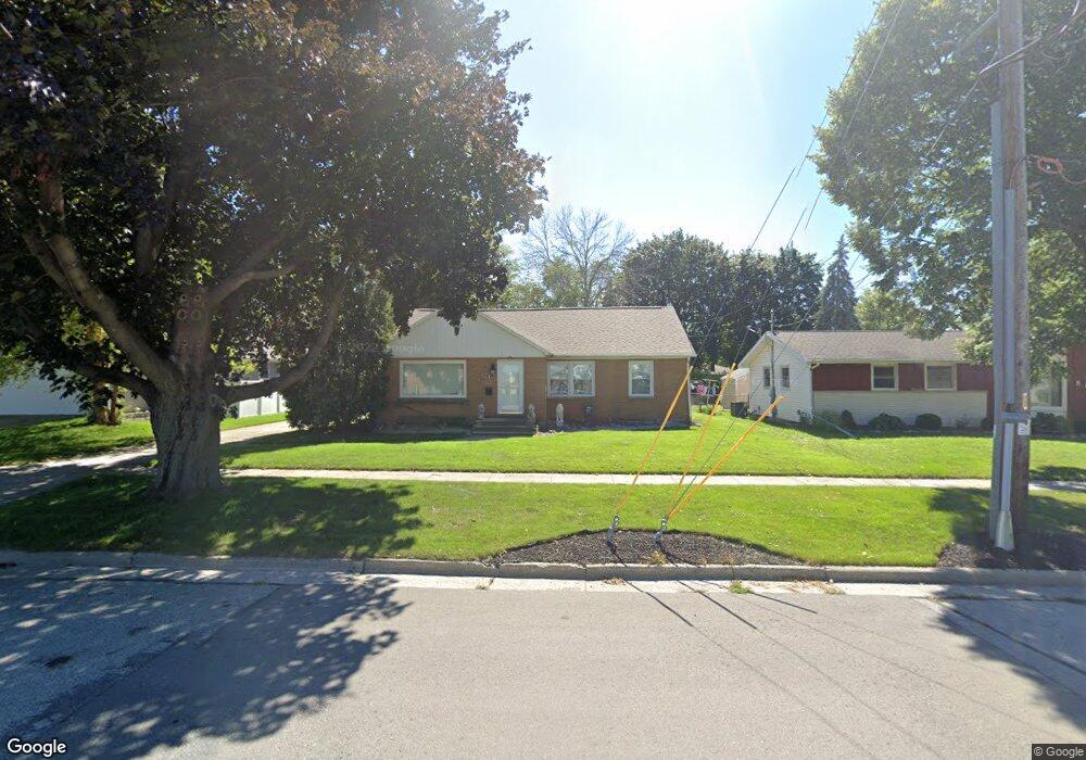
809 Ash St de Pere, WI 54115
Estimated Value: $269,000 - $300,957
3
Beds
2
Baths
1,484
Sq Ft
$195/Sq Ft
Est. Value
About This Home
This home is located at 809 Ash St, de Pere, WI 54115 and is currently estimated at $289,989, approximately $195 per square foot. 809 Ash St is a home located in Brown County with nearby schools including Westwood Elementary School, West De Pere Middle School, and West De Pere High School.
Ownership History
Date
Name
Owned For
Owner Type
Purchase Details
Closed on
Aug 24, 2007
Sold by
Eserkaln Michael T and Eserkaln Peggy S
Bought by
Rau Kevin G
Current Estimated Value
Home Financials for this Owner
Home Financials are based on the most recent Mortgage that was taken out on this home.
Original Mortgage
$118,900
Outstanding Balance
$19,414
Interest Rate
6.72%
Mortgage Type
Purchase Money Mortgage
Estimated Equity
$270,575
Purchase Details
Closed on
Dec 12, 2001
Sold by
Eserkaln Michael T and Eserkaln Peggy S
Bought by
Eserkaln Michael T and Eserkaln Peggy S
Home Financials for this Owner
Home Financials are based on the most recent Mortgage that was taken out on this home.
Original Mortgage
$89,600
Interest Rate
8.37%
Create a Home Valuation Report for This Property
The Home Valuation Report is an in-depth analysis detailing your home's value as well as a comparison with similar homes in the area
Home Values in the Area
Average Home Value in this Area
Purchase History
| Date | Buyer | Sale Price | Title Company |
|---|---|---|---|
| Rau Kevin G | $128,900 | Land Office Title Corp | |
| Eserkaln Michael T | -- | Bay Title & Abstract Inc |
Source: Public Records
Mortgage History
| Date | Status | Borrower | Loan Amount |
|---|---|---|---|
| Open | Rau Kevin G | $118,900 | |
| Previous Owner | Eserkaln Michael T | $89,600 | |
| Closed | Eserkaln Michael T | $22,400 |
Source: Public Records
Tax History Compared to Growth
Tax History
| Year | Tax Paid | Tax Assessment Tax Assessment Total Assessment is a certain percentage of the fair market value that is determined by local assessors to be the total taxable value of land and additions on the property. | Land | Improvement |
|---|---|---|---|---|
| 2024 | $4,013 | $281,300 | $31,500 | $249,800 |
| 2023 | $3,839 | $261,700 | $31,500 | $230,200 |
| 2022 | $3,759 | $229,400 | $31,500 | $197,900 |
| 2021 | $3,616 | $203,100 | $26,200 | $176,900 |
| 2020 | $3,638 | $188,700 | $26,200 | $162,500 |
| 2019 | $3,353 | $176,400 | $26,200 | $150,200 |
| 2018 | $3,200 | $162,600 | $26,200 | $136,400 |
| 2017 | $2,932 | $144,500 | $26,200 | $118,300 |
| 2016 | $2,938 | $144,500 | $26,200 | $118,300 |
| 2015 | $2,981 | $137,500 | $26,300 | $111,200 |
| 2014 | $2,943 | $137,500 | $26,300 | $111,200 |
| 2013 | $2,943 | $137,500 | $26,300 | $111,200 |
Source: Public Records
Map
Nearby Homes
- 721 Cedar St
- 657 Reid St
- 555 Main Ave Unit 104
- 555 Main Ave Unit 111
- 555 Main Ave Unit 113
- 555 Main Ave Unit 110
- 555 Main Ave Unit 206
- 634 Grant St
- 1115 Twilight Dr Unit 1117
- 3161 Trinity Ct
- 3106 Trinity Ct
- 3166 Trinity Ct
- 200 William St Unit 402
- 978 Saint Anthony Dr Unit 980
- 978 Saint Anthony Dr Unit 2
- 501 Dunning Dr
- 717 4th St
- 806 4th St
- 1611 N Honeysuckle Cir
- 305 Battery Ave