
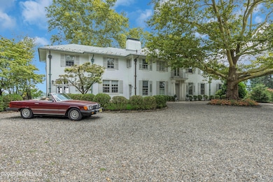
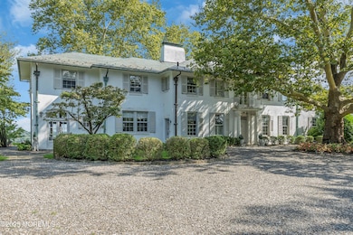
809 Navesink River Rd Rumson, NJ 07760
Locust NeighborhoodEstimated payment $18,194/month
Highlights
- Pool House
- River View
- Colonial Architecture
- Navesink Elementary School Rated A
- New Kitchen
- Marble Flooring
About This Home
This exquisitely renovated home offers a perfect blend of modern luxury & serene countryside living. With captivating views of the Navesink River, this 5 bed 3.5 bath property is a true gem. The classic floor plan seamlessly connects the living, dining, & kitchen areas, creating an inviting space for both relaxation & entertainment. Large windows throughout the main living spaces allow an abundance of natural light to provide uninterrupted vistas of the water. The expansive patio areas provide the perfect setting for outdoor gatherings. The lush lawn leads down to the pool & cabana complete with bar, powder room & changing room w/ shower. This renovated home with modern amenities, & meticulous attention to detail, represents a rare opportunity to experience the epitome of living in this beautifully restored setting. Within easy reach of both Red Bank & Rumson, enjoy the convenience of local amenities, excellent schools, ferry direct to NYC & a multitude of dining & entertainment options!
Home Details
Home Type
- Single Family
Est. Annual Taxes
- $37,445
Year Built
- Built in 1910
Lot Details
- Oversized Lot
- Sprinkler System
Parking
- 5 Car Detached Garage
- Circular Driveway
- Gravel Driveway
Home Design
- Colonial Architecture
- Slate Roof
- Stucco Exterior
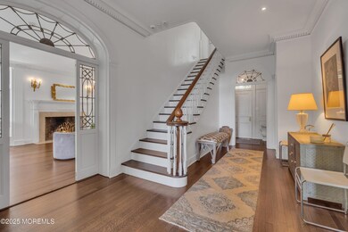
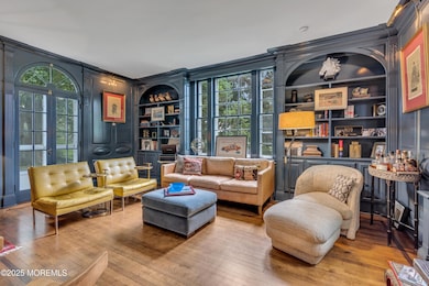
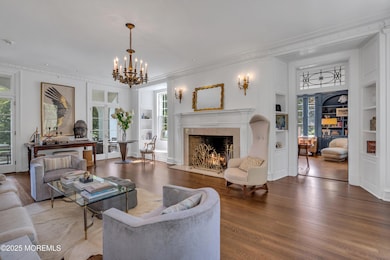
Interior Spaces
- 5,892 Sq Ft Home
- 2-Story Property
- Built-In Features
- Crown Molding
- Ceiling height of 9 feet on the main level
- Recessed Lighting
- Fireplace
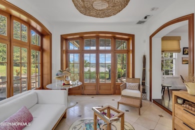
- Bay Window
- French Doors
- Mud Room
- Entrance Foyer
- Family Room
- Living Room
- Dining Room
- Home Office
- Bonus Room
- Home Gym
- Center Hall
- River Views
- Unfinished Basement
- Heated Basement
- Walkup Attic
- Home Security System
- Laundry Room
Kitchen
- New Kitchen
- Eat-In Kitchen
- Stove
- Portable Range
- Range Hood
- Dishwasher
- Kitchen Island
- Granite Countertops
Flooring
- Wood
- Marble
Bedrooms and Bathrooms
- 5 Bedrooms
- Primary bedroom located on second floor
- Walk-In Closet
- Primary Bathroom is a Full Bathroom
- Dual Vanity Sinks in Primary Bathroom
- Primary Bathroom Bathtub Only
- Primary Bathroom includes a Walk-In Shower
Pool
- Pool House
- Concrete Pool
- Heated In Ground Pool
- Fence Around Pool
Outdoor Features
- Balcony
- Patio
- Terrace
- Exterior Lighting
- Porch
Utilities
- Forced Air Zoned Heating and Cooling System
- Heating System Uses Natural Gas
- Heating System Uses Oil Below Ground
- Radiant Heating System
- Natural Gas Water Heater
- Septic Tank
- Septic System
Community Details
- No Home Owners Association
Listing and Financial Details
- Assessor Parcel Number 32-00840-0000-00087
Map
Home Values in the Area
Average Home Value in this Area
Tax History
| Year | Tax Paid | Tax Assessment Tax Assessment Total Assessment is a certain percentage of the fair market value that is determined by local assessors to be the total taxable value of land and additions on the property. | Land | Improvement |
|---|---|---|---|---|
| 2025 | $37,445 | $2,429,600 | $989,500 | $1,440,100 |
| 2024 | $31,390 | $2,276,300 | $862,600 | $1,413,700 |
| 2023 | $31,390 | $1,806,100 | $829,400 | $976,700 |
| 2022 | $45,788 | $1,697,900 | $768,000 | $929,900 |
| 2021 | $45,788 | $2,213,600 | $1,415,000 | $798,600 |
| 2020 | $46,940 | $2,195,500 | $1,415,000 | $780,500 |
| 2019 | $46,464 | $2,200,000 | $1,415,000 | $785,000 |
| 2018 | $54,112 | $2,497,100 | $1,415,000 | $1,082,100 |
| 2017 | $49,791 | $2,344,200 | $1,415,000 | $929,200 |
| 2016 | $49,501 | $2,322,900 | $1,415,000 | $907,900 |
| 2015 | $49,391 | $2,312,300 | $1,415,000 | $897,300 |
| 2014 | $48,926 | $2,235,100 | $1,415,000 | $820,100 |
Property History
| Date | Event | Price | List to Sale | Price per Sq Ft |
|---|---|---|---|---|
| 12/22/2025 12/22/25 | Pending | -- | -- | -- |
| 09/04/2025 09/04/25 | For Sale | $2,929,000 | 0.0% | $497 / Sq Ft |
| 08/18/2025 08/18/25 | Pending | -- | -- | -- |
| 08/04/2025 08/04/25 | For Sale | $2,929,000 | -- | $497 / Sq Ft |
Purchase History
| Date | Type | Sale Price | Title Company |
|---|---|---|---|
| Deed | $1,650,000 | -- | |
| Bargain Sale Deed | $1,650,000 | Key Settlements Inc | |
| Bargain Sale Deed | $1,650,000 | Land Title | |
| Deed | $3,715,000 | -- |
Mortgage History
| Date | Status | Loan Amount | Loan Type |
|---|---|---|---|
| Closed | -- | No Value Available |
Source: MOREMLS (Monmouth Ocean Regional REALTORS®)
MLS Number: 22523276
APN: 32-00840-0000-00087
Disclaimer: Certain information contained herein is derived from information provided by parties other than Homes.com. All information provided is deemed reliable, but is not guaranteed to be accurate and should be independently verified.
![]() IDX information is provided exclusively for personal, non-commercial use, and may not be used for any purpose other than to identify prospective properties consumers may be interested in purchasing.
IDX information is provided exclusively for personal, non-commercial use, and may not be used for any purpose other than to identify prospective properties consumers may be interested in purchasing.
Information is deemed reliable but not guaranteed.
- 934 Navesink River Rd
- 1 2nd St
- 4 Circle Dr
- 6 3rd St
- 56 Woodland Dr
- 15 Buena Vista Ave
- 14 Church St
- 5 Oakwood Ln
- 139 Monmouth Ave
- 50 Northover Place
- 70 Valley Dr E
- 80 Bingham Ave
- 96 East Ave Unit 82
- 96 East Ave Unit 76
- 96 East Ave Unit 97
- 90 Washington St
- 86 Lafayette St
- 224 Fair Haven Rd
- 498 Central Ave
- 39 E River Rd

Ask me questions while you tour the home.