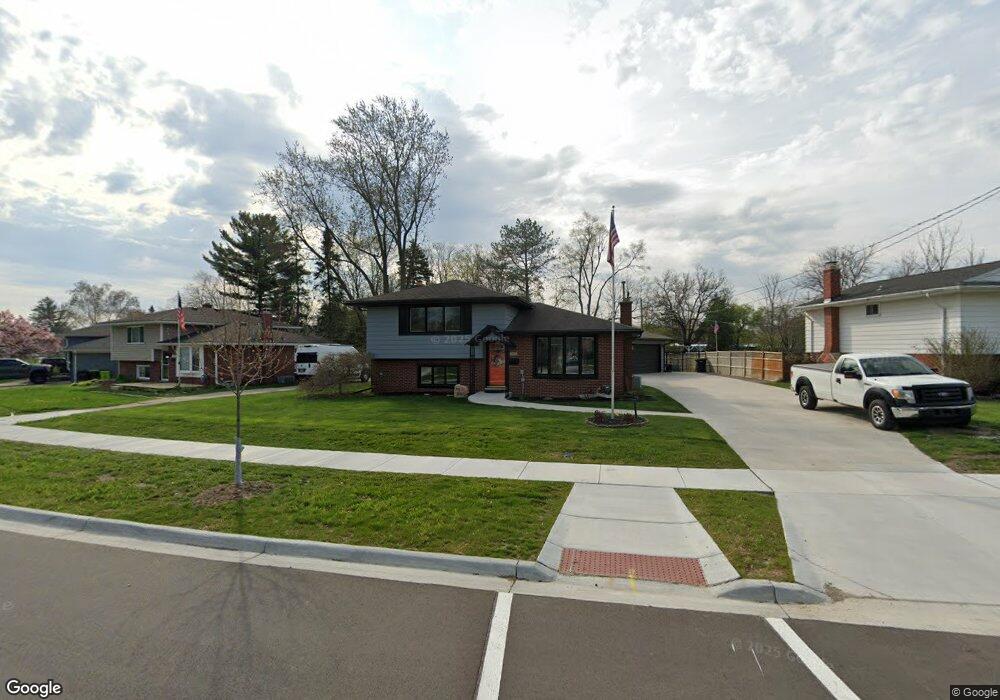
809 Worchester Dr Fenton, MI 48430
Estimated Value: $251,000 - $331,000
3
Beds
2
Baths
1,814
Sq Ft
$158/Sq Ft
Est. Value
About This Home
This home is located at 809 Worchester Dr, Fenton, MI 48430 and is currently estimated at $286,546, approximately $157 per square foot. 809 Worchester Dr is a home located in Genesee County with nearby schools including Fenton Senior High School and St. John the Evangelist Catholic School.
Ownership History
Date
Name
Owned For
Owner Type
Purchase Details
Closed on
Sep 13, 2022
Sold by
Lynn Leighton Cheryl
Bought by
Leighton Dale G and Leighton Cheryl L
Current Estimated Value
Purchase Details
Closed on
Jun 2, 2003
Sold by
Leighton Cheryl L and Wittersheim Cheryl L
Bought by
Leighton Cheryl L
Home Financials for this Owner
Home Financials are based on the most recent Mortgage that was taken out on this home.
Original Mortgage
$132,000
Interest Rate
6.49%
Mortgage Type
New Conventional
Create a Home Valuation Report for This Property
The Home Valuation Report is an in-depth analysis detailing your home's value as well as a comparison with similar homes in the area
Home Values in the Area
Average Home Value in this Area
Purchase History
| Date | Buyer | Sale Price | Title Company |
|---|---|---|---|
| Leighton Dale G | -- | -- | |
| Leighton Cheryl L | -- | Michigan Land Title Agency I |
Source: Public Records
Mortgage History
| Date | Status | Borrower | Loan Amount |
|---|---|---|---|
| Previous Owner | Leighton Cheryl L | $132,000 | |
| Closed | Leighton Cheryl L | $16,500 |
Source: Public Records
Tax History Compared to Growth
Tax History
| Year | Tax Paid | Tax Assessment Tax Assessment Total Assessment is a certain percentage of the fair market value that is determined by local assessors to be the total taxable value of land and additions on the property. | Land | Improvement |
|---|---|---|---|---|
| 2025 | $3,722 | $148,300 | $0 | $0 |
| 2024 | $2,550 | $138,600 | $0 | $0 |
| 2023 | $1,595 | $92,800 | $0 | $0 |
| 2022 | $2,229 | $85,600 | $0 | $0 |
| 2021 | $2,000 | $78,000 | $0 | $0 |
| 2020 | $1,314 | $74,200 | $0 | $0 |
| 2019 | $1,302 | $66,000 | $0 | $0 |
| 2018 | $1,905 | $68,500 | $0 | $0 |
| 2017 | $1,835 | $63,200 | $0 | $0 |
| 2016 | $1,822 | $53,500 | $0 | $0 |
| 2015 | $1,862 | $54,700 | $0 | $0 |
| 2012 | -- | $44,600 | $44,600 | $0 |
Source: Public Records
Map
Nearby Homes
- 911 Newport Dr
- 621 Forest Dr
- 914 North Rd
- 872 W Silver Lake Rd
- 01 North Rd
- 1001 Worchester Dr
- 624 Hickory St
- 2420 North Rd
- 15181 Charluene Dr
- 411 Jefferson St
- 476 Remington Ct
- 405 Lincoln St
- 15116 Charluene Dr
- 229 Meadow Pointe Dr
- 211 Colfax St
- 0 W Caroline St
- 315 Meadow Pointe Dr Unit 59
- 15173 North Rd
- 501 N Leroy St
- 14521 Appletree Ln
- 901 Worchester Dr
- 803 Worchester Dr
- 903 Worchester Dr
- 808 Worchester Dr
- 902 Worchester Dr
- 806 Worchester Dr
- 715 Worchester Dr
- 905 Worchester Dr
- 906 Worchester Dr
- 804 Worchester Dr
- 902 Newport Dr
- 901 Newport Dr
- 713 Worchester Dr
- 802 Worchester Dr
- 907 Worchester Dr
- 912 Worchester Dr
- 903 Newport Dr
- 807 Briarwood Ln
- 901 Briarwood Ln
- 711 Worchester Dr