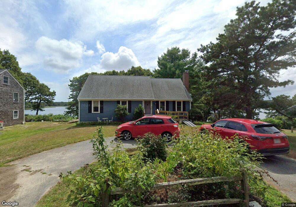
81 Alfred Metcalf Dr South Dennis, MA 02660
South Dennis NeighborhoodEstimated Value: $587,000 - $762,000
3
Beds
3
Baths
1,192
Sq Ft
$585/Sq Ft
Est. Value
About This Home
This home is located at 81 Alfred Metcalf Dr, South Dennis, MA 02660 and is currently estimated at $696,887, approximately $584 per square foot. 81 Alfred Metcalf Dr is a home located in Barnstable County with nearby schools including Dennis-Yarmouth Regional High School and St. Pius X. School.
Ownership History
Date
Name
Owned For
Owner Type
Purchase Details
Closed on
Aug 24, 2021
Sold by
Oconnor Carol A and Oconnor Daniel J
Bought by
Oconnor Daniel J
Current Estimated Value
Purchase Details
Closed on
Jul 18, 1985
Bought by
Oconnor Daniel J and Oconnor Carol A
Create a Home Valuation Report for This Property
The Home Valuation Report is an in-depth analysis detailing your home's value as well as a comparison with similar homes in the area
Home Values in the Area
Average Home Value in this Area
Purchase History
| Date | Buyer | Sale Price | Title Company |
|---|---|---|---|
| Oconnor Daniel J | -- | None Available | |
| Oconnor Daniel J | $40,000 | -- |
Source: Public Records
Mortgage History
| Date | Status | Borrower | Loan Amount |
|---|---|---|---|
| Previous Owner | Oconnor Daniel J | $75,000 |
Source: Public Records
Tax History Compared to Growth
Tax History
| Year | Tax Paid | Tax Assessment Tax Assessment Total Assessment is a certain percentage of the fair market value that is determined by local assessors to be the total taxable value of land and additions on the property. | Land | Improvement |
|---|---|---|---|---|
| 2025 | $3,042 | $702,600 | $296,400 | $406,200 |
| 2024 | $2,935 | $668,500 | $285,000 | $383,500 |
| 2023 | $2,984 | $638,900 | $290,200 | $348,700 |
| 2022 | $2,933 | $523,700 | $261,400 | $262,300 |
| 2021 | $2,858 | $474,000 | $256,300 | $217,700 |
| 2020 | $2,784 | $456,400 | $256,300 | $200,100 |
| 2019 | $2,482 | $402,200 | $224,400 | $177,800 |
| 2018 | $2,378 | $375,100 | $213,600 | $161,500 |
| 2017 | $2,275 | $369,900 | $213,600 | $156,300 |
| 2016 | $2,465 | $377,500 | $247,700 | $129,800 |
| 2015 | $2,416 | $377,500 | $247,700 | $129,800 |
| 2014 | $2,376 | $374,100 | $247,700 | $126,400 |
Source: Public Records
Map
Nearby Homes
- 153 Bayridge Dr
- 4 Ebb Rd
- 11 Uncle Stanleys Way
- 17 Margate Ln
- 118 Driftwood Ln
- 17 Fairmount Rd
- 15 Captain Jud Rd
- 17 Fairmount Rd
- 129 Driftwood Ln
- 10 Joanne Dr
- 13 Covey Dr
- 7 Vinland Dr
- 111 Merchant Ave
- 25 Skerry Rd
- 1 Norseman Dr
- 4 Old Colony Way
- 62 Old Fish House Rd
- 6 Hawthorn St
- 6 Nimble Hill Dr
- 85 Keel Cape Dr
- 75 Alfred Metcalf Dr
- 85 Alfred Metcalf Dr
- 76 Alfred Metcalf Dr
- 84 Alfred Metcalf Dr
- 34 Norse Rd
- 29 Olivia Walker Way
- 91 Alfred Metcalf Dr
- 30 Olivia Walker Way
- 27 Robert Arthur Way
- 30 Norse Rd
- 52 Alfred Metcalf Dr
- 25 Olivia Walker Way
- 26 Norse Rd
- 67 Alfred Metcalf Dr
- 87 Alfred Metcalf Dr
- 24 Norse Rd
- 21 Olivia Walker Way
- 25 Robert Arthur Way
- 94 Alfred Metcalf Dr
- 95 Alfred Metcalf Dr