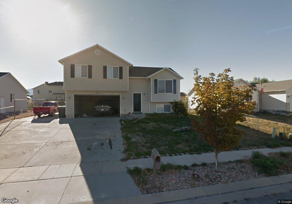
81 Aspen Way Grantsville, UT 84029
Estimated Value: $352,000 - $398,000
3
Beds
1
Bath
1,648
Sq Ft
$232/Sq Ft
Est. Value
About This Home
This home is located at 81 Aspen Way, Grantsville, UT 84029 and is currently estimated at $382,030, approximately $231 per square foot. 81 Aspen Way is a home located in Tooele County with nearby schools including Twenty Wells Elementary, Grantsville Junior High School, and Grantsville High School.
Ownership History
Date
Name
Owned For
Owner Type
Purchase Details
Closed on
May 6, 2019
Sold by
Bergener Brandon
Bought by
Bergener Melanie and Bergener Brandon
Current Estimated Value
Home Financials for this Owner
Home Financials are based on the most recent Mortgage that was taken out on this home.
Original Mortgage
$187,500
Interest Rate
4%
Mortgage Type
New Conventional
Purchase Details
Closed on
Mar 20, 2014
Sold by
Bergener Brandon J and Bergener Brandon
Bought by
Bergener Brandon
Create a Home Valuation Report for This Property
The Home Valuation Report is an in-depth analysis detailing your home's value as well as a comparison with similar homes in the area
Home Values in the Area
Average Home Value in this Area
Purchase History
| Date | Buyer | Sale Price | Title Company |
|---|---|---|---|
| Bergener Melanie | -- | Metro National Title | |
| Bergener Brandon | -- | Cornerstone Title Ins Agen | |
| Bergener Brandon | -- | Cornerstone Title Tooele |
Source: Public Records
Mortgage History
| Date | Status | Borrower | Loan Amount |
|---|---|---|---|
| Closed | Bergener Melanie | $187,500 |
Source: Public Records
Tax History Compared to Growth
Tax History
| Year | Tax Paid | Tax Assessment Tax Assessment Total Assessment is a certain percentage of the fair market value that is determined by local assessors to be the total taxable value of land and additions on the property. | Land | Improvement |
|---|---|---|---|---|
| 2025 | $2,164 | $190,161 | $36,080 | $154,081 |
| 2024 | $2,164 | $176,677 | $36,080 | $140,597 |
| 2023 | $2,164 | $159,837 | $37,840 | $121,997 |
| 2022 | $1,763 | $162,241 | $39,501 | $122,740 |
| 2021 | $1,596 | $119,783 | $31,460 | $88,323 |
| 2020 | $1,564 | $206,639 | $57,200 | $149,439 |
| 2019 | $1,484 | $191,575 | $30,000 | $161,575 |
| 2018 | $1,455 | $176,886 | $30,000 | $146,886 |
| 2017 | $1,268 | $163,533 | $30,000 | $133,533 |
| 2016 | $1,206 | $83,267 | $16,500 | $66,767 |
| 2015 | $1,206 | $83,267 | $0 | $0 |
| 2014 | -- | $60,847 | $0 | $0 |
Source: Public Records
Map
Nearby Homes
- 185 Waterhole Way
- 653 E Main St Unit 45
- 635 Wildrose Dr
- 187 Waterhole Way
- 72 S Mustang Ridge Rd Unit 109
- 697 E Main St
- 699 E Main St
- 600 Clay St
- 601 Clay St
- 799 E Main St
- 113 Utah 112
- 573 S Eyring Place
- 359 S Archwood Way Unit 617
- 135 Willow St
- 52 East St
- 122 S Liberty Landing Unit 201
- 132 Willow St
- 130 S Liberty Landing Unit 202
- 144 S Liberty Landing Unit 203
- 421 E Stafford St Unit 134