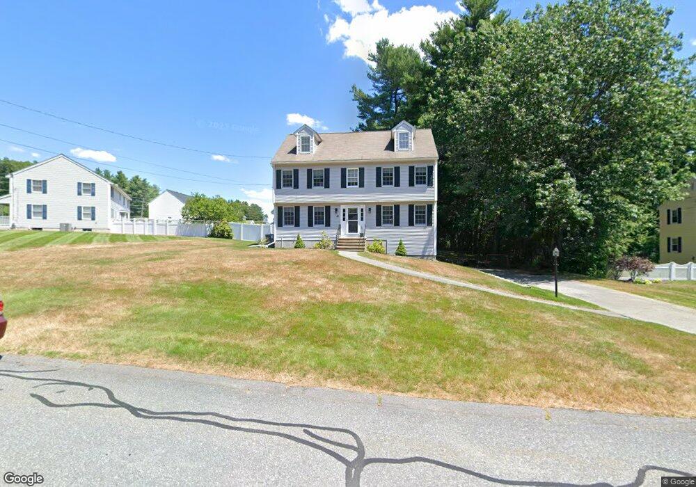
81 Fox Run Dr Tewksbury, MA 01876
Estimated Value: $861,000 - $929,000
4
Beds
3
Baths
2,052
Sq Ft
$430/Sq Ft
Est. Value
About This Home
This home is located at 81 Fox Run Dr, Tewksbury, MA 01876 and is currently estimated at $882,524, approximately $430 per square foot. 81 Fox Run Dr is a home located in Middlesex County with nearby schools including John F. Ryan Elementary School, John W. Wynn Middle School, and Tewksbury Memorial High School.
Ownership History
Date
Name
Owned For
Owner Type
Purchase Details
Closed on
Jul 30, 1998
Sold by
B&B Halfo Inc
Bought by
Arsenault James P and Arsenault Michele H
Current Estimated Value
Home Financials for this Owner
Home Financials are based on the most recent Mortgage that was taken out on this home.
Original Mortgage
$190,900
Outstanding Balance
$39,825
Interest Rate
6.92%
Mortgage Type
Purchase Money Mortgage
Estimated Equity
$842,699
Create a Home Valuation Report for This Property
The Home Valuation Report is an in-depth analysis detailing your home's value as well as a comparison with similar homes in the area
Home Values in the Area
Average Home Value in this Area
Purchase History
| Date | Buyer | Sale Price | Title Company |
|---|---|---|---|
| Arsenault James P | $262,900 | -- |
Source: Public Records
Mortgage History
| Date | Status | Borrower | Loan Amount |
|---|---|---|---|
| Open | Arsenault James P | $190,900 |
Source: Public Records
Tax History Compared to Growth
Tax History
| Year | Tax Paid | Tax Assessment Tax Assessment Total Assessment is a certain percentage of the fair market value that is determined by local assessors to be the total taxable value of land and additions on the property. | Land | Improvement |
|---|---|---|---|---|
| 2025 | $9,739 | $736,700 | $336,400 | $400,300 |
| 2024 | $9,530 | $711,700 | $320,400 | $391,300 |
| 2023 | $9,258 | $656,600 | $291,400 | $365,200 |
| 2022 | $8,760 | $576,300 | $253,400 | $322,900 |
| 2021 | $9,349 | $555,700 | $230,400 | $325,300 |
| 2020 | $8,419 | $527,200 | $219,400 | $307,800 |
| 2019 | $7,334 | $463,000 | $208,800 | $254,200 |
| 2018 | $6,864 | $441,100 | $208,800 | $232,300 |
| 2017 | $7,132 | $437,300 | $208,800 | $228,500 |
| 2016 | $6,846 | $418,700 | $208,800 | $209,900 |
| 2015 | $6,718 | $410,400 | $208,800 | $201,600 |
| 2014 | $6,489 | $402,800 | $217,600 | $185,200 |
Source: Public Records
Map
Nearby Homes
- 10 Babicz Rd
- 71 Secor Way
- 347 Astle St
- 43 Oak Knoll Rd
- 122 Marshall St
- 11 Nelson Ave
- 357 Boylston St Unit 2
- 86 Van Buren Rd
- 82 Boylston Ln Unit 16
- 1 Lincoln Rd
- 32 Rockingham St Unit A
- 90 Roper St Unit G
- 16 Crooked Spring Rd
- 11 Emerald Ct
- 188 Poland Ave
- 50 Arnold Ave
- 206 Shoreline Dr
- 193 Shoreline Dr
- 189 Lakeview St
- 160 Booth St