
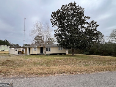
81 Langston Ave Forsyth, GA 31029
Estimated payment $945/month
Highlights
- Popular Property
- Corner Lot
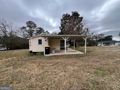
- Shed
- Samuel E. Hubbard Elementary School Rated A-
- No HOA
- 1-Story Property
About This Home
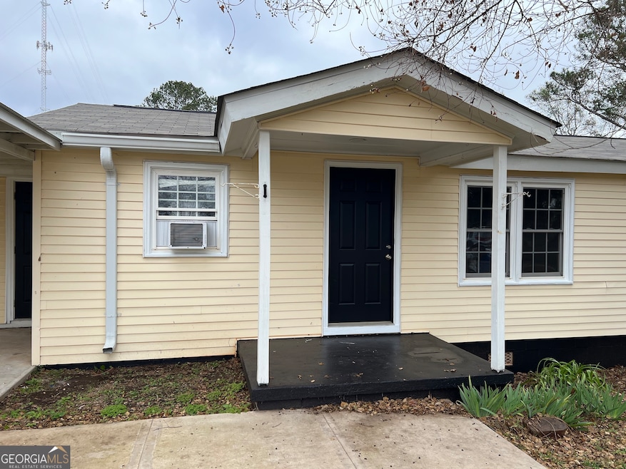
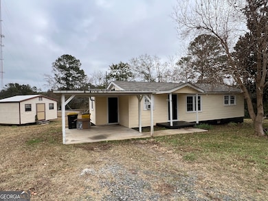
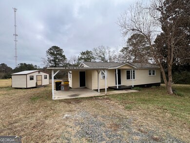
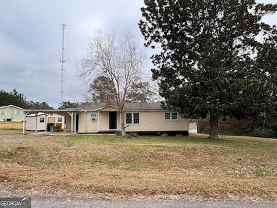
Charming Forsyth Home Near Forsyth City Park! Welcome to 81 Langston Avenue-a cozy and well-maintained 3-bedroom, 1-bath home offering 840 sq ft of comfortable living space. This property features new LVP flooring throughout, a new stove, covered carport, storage shed, and public water and sewer. Enjoy the efficiency and reliability of natural gas, including a natural gas water heater, natural gas stove, and a natural gas floor furnace. With no HOA, you'll appreciate added flexibility and freedom. Conveniently located just half a mile from the city golf course, splash pad, and Forsyth City Park, you'll have easy access to all the local recreation and community amenities the area has to offer. The property is vacant and easy to show-perfect for first-time buyers, investors, or anyone looking to downsize.
Listing Agent
PrimePoint Ventures Brokerage Phone: 4783944545 License #216409 Listed on: 12/03/2025
Home Details
Home Type
- Single Family
Est. Annual Taxes
- $959
Year Built
- Built in 1964
Lot Details
- 0.5 Acre Lot
- Corner Lot
- Level Lot
Home Design
- Fixer Upper
- Composition Roof
- Vinyl Siding
Interior Spaces
- 840 Sq Ft Home
- 1-Story Property
- Carpet
- Cooktop
Bedrooms and Bathrooms
- 2 Main Level Bedrooms
- 1 Full Bathroom
Parking
- Over 1 Space Per Unit
- Parking Shed
Outdoor Features
- Shed
Schools
- Hubbard Elementary School
- Monroe County Middle School
- Mary Persons High School
Utilities
- Window Unit Cooling System
- Central Heating
- High Speed Internet
- Phone Available
- Cable TV Available
Community Details
- No Home Owners Association
- Brighton Heights Subdivision
Map
Home Values in the Area
Average Home Value in this Area
Tax History
| Year | Tax Paid | Tax Assessment Tax Assessment Total Assessment is a certain percentage of the fair market value that is determined by local assessors to be the total taxable value of land and additions on the property. | Land | Improvement |
|---|---|---|---|---|
| 2024 | $999 | $35,504 | $4,240 | $31,264 |
| 2023 | $959 | $30,424 | $4,240 | $26,184 |
| 2022 | $824 | $30,424 | $4,240 | $26,184 |
| 2021 | $399 | $14,240 | $4,240 | $10,000 |
| 2020 | $409 | $14,240 | $4,240 | $10,000 |
| 2019 | $380 | $13,116 | $3,400 | $9,716 |
| 2018 | $0 | $13,116 | $3,400 | $9,716 |
| 2017 | $381 | $13,116 | $3,400 | $9,716 |
| 2016 | $31 | $13,116 | $3,400 | $9,716 |
| 2015 | $2 | $12,076 | $3,400 | $8,676 |
| 2014 | $3 | $12,076 | $3,400 | $8,676 |
Property History
| Date | Event | Price | List to Sale | Price per Sq Ft |
|---|---|---|---|---|
| 12/03/2025 12/03/25 | For Sale | $164,900 | -- | $196 / Sq Ft |
Purchase History
| Date | Type | Sale Price | Title Company |
|---|---|---|---|
| Warranty Deed | $85,000 | -- | |
| Warranty Deed | -- | -- | |
| Deed | -- | -- |
Mortgage History
| Date | Status | Loan Amount | Loan Type |
|---|---|---|---|
| Closed | $84,500 | Cash |
Source: Georgia MLS
MLS Number: 10652585
APN: F04-011
Disclaimer: Certain information contained herein is derived from information provided by parties other than Homes.com. All information provided is deemed reliable, but is not guaranteed to be accurate and should be independently verified.
![]() The data relating to real estate for sale on this web site comes in part from the Broker Reciprocity Program of Georgia MLS. Real estate listings held by brokerage firms other than Redfin are marked with the Broker Reciprocity logo and detailed information about them includes the name of the listing brokers. Information deemed reliable but not guaranteed. Copyright 2025 Georgia MLS. All rights reserved.
The data relating to real estate for sale on this web site comes in part from the Broker Reciprocity Program of Georgia MLS. Real estate listings held by brokerage firms other than Redfin are marked with the Broker Reciprocity logo and detailed information about them includes the name of the listing brokers. Information deemed reliable but not guaranteed. Copyright 2025 Georgia MLS. All rights reserved.
- 112 Cedar St
- 182 James St
- 600 Holiday Cir
- 101 Owens Ln
- 301 Barrington Hall Dr
- 1469 Highway 42 N
- 1644 Bass Rd
- 1091 Overlook Pkwy
- 5578 Riverside Dr
- 114 Randall Ave
- 5437 Bowman Rd
- 105 Bass Plantation Dr
- 5560 Riverside Dr
- 6435 Zebulon Rd
- 600 Lamar Rd
- 428 Grand Magnolia St
- 399 Plantation Way
- 486 Grand Magnolia St
- 148 Flowering Cherry St
- 5235 Bowman Rd
