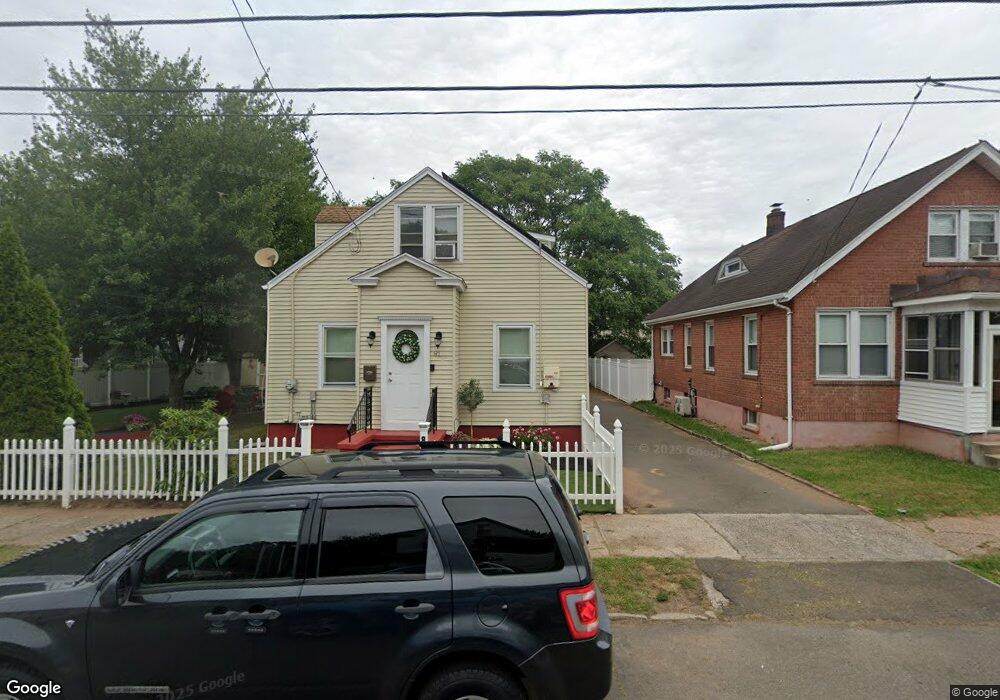
81 Lee St West Haven, CT 06516
Allingtown NeighborhoodEstimated Value: $329,000 - $404,000
4
Beds
2
Baths
1,500
Sq Ft
$252/Sq Ft
Est. Value
About This Home
This home is located at 81 Lee St, West Haven, CT 06516 and is currently estimated at $378,557, approximately $252 per square foot. 81 Lee St is a home located in New Haven County with nearby schools including Carrigan 5/6 Intermediate School, Harry M. Bailey Middle School, and West Haven High School.
Ownership History
Date
Name
Owned For
Owner Type
Purchase Details
Closed on
Feb 23, 2017
Sold by
Jean-Paul Guy and Jean-Paul Marjorie
Bought by
Jean-Paul Marjorie
Current Estimated Value
Purchase Details
Closed on
Nov 21, 2001
Sold by
Aliaga Betsy L
Bought by
Jean-Paul Guy and Jean-Paul Marjorie
Home Financials for this Owner
Home Financials are based on the most recent Mortgage that was taken out on this home.
Original Mortgage
$125,530
Interest Rate
6.64%
Mortgage Type
Purchase Money Mortgage
Purchase Details
Closed on
Oct 25, 1999
Sold by
Zurolo Arlene
Bought by
Aliaga Betsy L
Create a Home Valuation Report for This Property
The Home Valuation Report is an in-depth analysis detailing your home's value as well as a comparison with similar homes in the area
Home Values in the Area
Average Home Value in this Area
Purchase History
| Date | Buyer | Sale Price | Title Company |
|---|---|---|---|
| Jean-Paul Marjorie | -- | -- | |
| Jean-Paul Guy | $127,500 | -- | |
| Aliaga Betsy L | $75,000 | -- | |
| Jean-Paul Marjorie | -- | -- | |
| Jean-Paul Guy | $127,500 | -- | |
| Aliaga Betsy L | $75,000 | -- |
Source: Public Records
Mortgage History
| Date | Status | Borrower | Loan Amount |
|---|---|---|---|
| Previous Owner | Aliaga Betsy L | $125,530 | |
| Previous Owner | Aliaga Betsy L | $70,700 |
Source: Public Records
Tax History Compared to Growth
Tax History
| Year | Tax Paid | Tax Assessment Tax Assessment Total Assessment is a certain percentage of the fair market value that is determined by local assessors to be the total taxable value of land and additions on the property. | Land | Improvement |
|---|---|---|---|---|
| 2025 | $7,556 | $222,180 | $63,560 | $158,620 |
| 2024 | $6,772 | $141,400 | $44,030 | $97,370 |
| 2023 | $6,564 | $141,400 | $44,030 | $97,370 |
| 2022 | $6,449 | $141,400 | $44,030 | $97,370 |
| 2021 | $6,112 | $133,980 | $44,030 | $89,950 |
| 2020 | $6,038 | $117,250 | $35,700 | $81,550 |
| 2019 | $5,945 | $117,250 | $35,700 | $81,550 |
| 2018 | $5,783 | $117,250 | $35,700 | $81,550 |
| 2017 | $5,602 | $117,250 | $35,700 | $81,550 |
| 2016 | $5,432 | $117,250 | $35,700 | $81,550 |
| 2015 | $5,201 | $127,820 | $38,360 | $89,460 |
| 2014 | $5,097 | $127,820 | $38,360 | $89,460 |
Source: Public Records
Map
Nearby Homes
- 65 Westfield St
- 22 Bristol St
- 82 Hemlock St
- 31 Hinman St
- 38 Chauncey St
- 148 Burwell Rd
- 0 Burwell Rd
- 14 Homestead Ave
- 0 Burwell & Woodfield Rd Unit 24051262
- 71 Sycaway St
- 36 Forest Hills Rd
- 50 Morris Ave
- 110 Fenwick St
- 57 Alling Street Extension
- 23 Yates St
- 129 Winthrop Ave
- 897 1st Ave
- 26 Auburn St
- 194 Ella T Grasso Blvd
- 212 West St