Estimated Value: $451,000 - $703,266
6
Beds
6
Baths
3,339
Sq Ft
$183/Sq Ft
Est. Value
About This Home
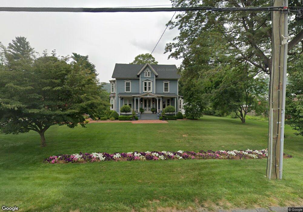
This home is located at 81 N Main St, Kent, CT 06757 and is currently estimated at $610,755, approximately $182 per square foot. 81 N Main St is a home located in Litchfield County with nearby schools including Kent Center School, Housatonic Valley Regional High School, and Kent School.
Ownership History
Date
Name
Owned For
Owner Type
Purchase Details
Closed on
Dec 11, 2019
Sold by
Abbate Steven
Bought by
Kent Victorian Llc
Current Estimated Value
Purchase Details
Closed on
Nov 1, 1996
Sold by
Orioles Frank P and Orioles Mary Anne
Bought by
Mauldin Ben G
Create a Home Valuation Report for This Property
The Home Valuation Report is an in-depth analysis detailing your home's value as well as a comparison with similar homes in the area
Home Values in the Area
Average Home Value in this Area
Purchase History
| Date | Buyer | Sale Price | Title Company |
|---|---|---|---|
| Kent Victorian Llc | -- | None Available | |
| Mauldin Ben G | $172,500 | -- |
Source: Public Records
Mortgage History
| Date | Status | Borrower | Loan Amount |
|---|---|---|---|
| Previous Owner | Mauldin Ben G | $403,640 | |
| Previous Owner | Mauldin Ben G | $60,000 | |
| Previous Owner | Mauldin Ben G | $36,000 |
Source: Public Records
Tax History Compared to Growth
Tax History
| Year | Tax Paid | Tax Assessment Tax Assessment Total Assessment is a certain percentage of the fair market value that is determined by local assessors to be the total taxable value of land and additions on the property. | Land | Improvement |
|---|---|---|---|---|
| 2025 | $7,020 | $416,100 | $0 | $416,100 |
| 2024 | $6,487 | $416,100 | $0 | $416,100 |
| 2023 | $6,889 | $367,200 | $0 | $367,200 |
| 2022 | $6,819 | $367,200 | $0 | $367,200 |
| 2021 | $6,819 | $367,200 | $0 | $367,200 |
| 2020 | $6,834 | $367,200 | $0 | $367,200 |
| 2019 | $8,136 | $437,200 | $70,000 | $367,200 |
| 2018 | $6,054 | $325,300 | $78,400 | $246,900 |
| 2017 | $6,054 | $325,300 | $78,400 | $246,900 |
| 2016 | $5,834 | $318,300 | $78,400 | $239,900 |
| 2015 | $5,685 | $318,300 | $78,400 | $239,900 |
| 2014 | $5,421 | $318,300 | $78,400 | $239,900 |
Source: Public Records
Map
Nearby Homes
- 13 Cobble Heights Rd
- 132 S Kent Rd
- 23 Mauwee Brook Rd
- 0 Spooner Hill Rd Unit 24077524
- 308 Skiff Mountain Rd
- 0 Richards Rd Unit 24140078
- 591 Bog Hollow Rd
- 0 Gorham Rd Unit 24138133
- 0 Mount Mauwee Rd
- 103 Geer Mountain Rd
- 221 Fuller Mountain Rd
- 5 Weantinogue Ln
- 441 Segar Mountain Rd
- 11 Old Paddock Ln
- 00 Camps Flat Rd
- 0 Stonewall Unit 39
- 00 Upper Kent Hollow Rd
- 1 W Woods Rd
- 73 Upper Kent Hollow Rd
- 263 Bog Hollow Rd
- 81 N Main St Unit 9
- 81 N Main St Unit 4
- 81 N Main St Unit 1
- 81 N Main St Unit 8
- 81 N Main St Unit 7
- 81 N Main St Unit 2
- 81 N Main St Unit 5
- 81 N Main St Unit 3
- 81 N Main St Unit 6
- 81 N Main St Unit 10
- 81 N Main St
- 81 N Main St Unit 10 & 11
- 81 N Main St Unit MAIN
- 81 N Main St Unit 11
- 81 N Main St Unit n/a
- 81 N Main St Unit 1-11
- 81 N Main St Unit 1-8
- 81 N Main St Unit 9-11
- 89B N Main St
- 89A N Main St