
Seller's Agent in 2025
Mary Noll
HomeSmart First Class Realty
(508) 277-6941
3 in this area
79 Total Sales
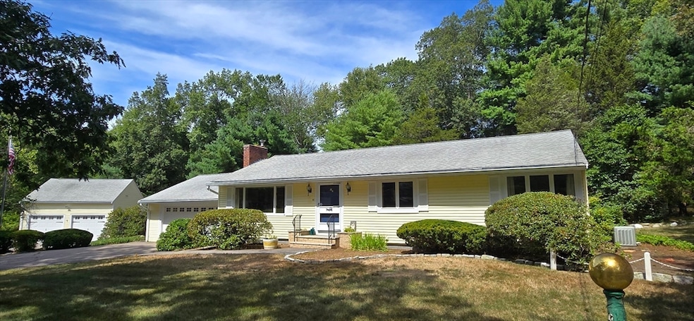
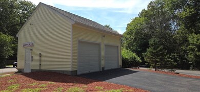
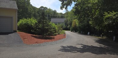

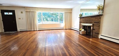
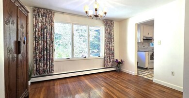

Diamond in the rough! Home is set on 1.3 acres, you have a 24' x 24' attached garage AND an OVERSIZED garage with front and back access doors for those who have a business with the need for storing large equipment, car enthusiast, or a mechanics dream garage. Detached garage has a circular driveway to maneuver whatever you will be storing in the detached garage. Interior of the home is a diamond in the rough. Your creative touches and sweat equity can add lots of value to this home!! Solidly built home is waiting for you to make it your own. One level living, 3 bedrooms, Hardwood floors, Two Full Baths, and basement is ready to finish. Nearby is Borderland State Park, which has running/walking paths, hiking, biking, fishing, disc golf, winter cross skiing and you can schedule a tour of the famous Ames Mansion, and is a dog friendly park. Also nearby is historic downtown Easton with plenty of places to eat, Easton Children's museum and nearby Stonehill College.
| Date | Type | Sale Price | Title Company |
|---|---|---|---|
| Deed | $625,000 | -- | |
| Deed | -- | -- | |
| Deed | -- | -- | |
| Deed | -- | -- |
| Date | Status | Loan Amount | Loan Type |
|---|---|---|---|
| Previous Owner | $87,500 | No Value Available | |
| Previous Owner | $99,000 | No Value Available | |
| Previous Owner | $118,000 | No Value Available |
| Date | Event | Price | List to Sale | Price per Sq Ft |
|---|---|---|---|---|
| 11/08/2025 11/08/25 | Sold | $625,000 | -10.7% | $446 / Sq Ft |
| 09/24/2025 09/24/25 | Pending | -- | -- | -- |
| 09/02/2025 09/02/25 | For Sale | $699,900 | -- | $500 / Sq Ft |
| Year | Tax Paid | Tax Assessment Tax Assessment Total Assessment is a certain percentage of the fair market value that is determined by local assessors to be the total taxable value of land and additions on the property. | Land | Improvement |
|---|---|---|---|---|
| 2025 | $7,474 | $598,900 | $371,100 | $227,800 |
| 2024 | $7,698 | $576,600 | $350,200 | $226,400 |
| 2023 | $7,489 | $513,300 | $350,200 | $163,100 |
| 2022 | $6,829 | $443,700 | $286,400 | $157,300 |
| 2021 | $6,478 | $418,500 | $261,200 | $157,300 |
| 2020 | $6,284 | $408,600 | $251,300 | $157,300 |
| 2019 | $6,046 | $378,800 | $249,800 | $129,000 |
| 2018 | $5,926 | $365,600 | $249,800 | $115,800 |
| 2017 | $5,888 | $363,000 | $249,800 | $113,200 |
| 2016 | $5,888 | $363,700 | $251,300 | $112,400 |
| 2015 | $5,281 | $314,700 | $204,900 | $109,800 |
| 2014 | $5,308 | $318,800 | $207,700 | $111,100 |
Seller's Agent in 2025
Mary Noll
HomeSmart First Class Realty
(508) 277-6941
3 in this area
79 Total Sales
Buyer's Agent in 2025
Robin Simon
HomeSmart First Class Realty
(617) 699-7603
3 in this area
66 Total Sales
Source: MLS Property Information Network (MLS PIN)
MLS Number: 73424540
APN: EAST-000005R-000011
Disclaimer: Certain information contained herein is derived from information provided by parties other than Homes.com. All information provided is deemed reliable, but is not guaranteed to be accurate and should be independently verified.
![]() The property listing data and information, or the Images, set forth herein were provided to MLS Property Information Network, Inc. from third party sources, including sellers, lessors and public records, and were compiled by MLS Property Information Network, Inc. The property listing data and information, and the Images, are for the personal, non-commercial use of consumers having a good faith interest in purchasing or leasing listed properties of the type displayed to them and may not be used for any purpose other than to identify prospective properties which such consumers may have a good faith interest in purchasing or leasing. MLS Property Information Network, Inc. and its subscribers disclaim any and all representations and warranties as to the accuracy of the property listing data and information, or as to the accuracy of any of the Images, set forth herein.
The property listing data and information, or the Images, set forth herein were provided to MLS Property Information Network, Inc. from third party sources, including sellers, lessors and public records, and were compiled by MLS Property Information Network, Inc. The property listing data and information, and the Images, are for the personal, non-commercial use of consumers having a good faith interest in purchasing or leasing listed properties of the type displayed to them and may not be used for any purpose other than to identify prospective properties which such consumers may have a good faith interest in purchasing or leasing. MLS Property Information Network, Inc. and its subscribers disclaim any and all representations and warranties as to the accuracy of the property listing data and information, or as to the accuracy of any of the Images, set forth herein.