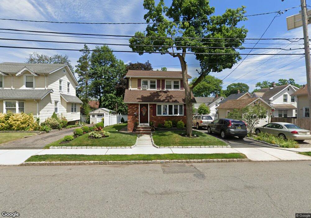
81 S Franklin Ave Bergenfield, NJ 07621
Estimated Value: $530,107 - $579,000
--
Bed
--
Bath
1,282
Sq Ft
$429/Sq Ft
Est. Value
About This Home
This home is located at 81 S Franklin Ave, Bergenfield, NJ 07621 and is currently estimated at $550,527, approximately $429 per square foot. 81 S Franklin Ave is a home located in Bergen County with nearby schools including Bergenfield High School and Solomon Schechter Day School.
Ownership History
Date
Name
Owned For
Owner Type
Purchase Details
Closed on
Jun 9, 2000
Sold by
Whitney Gloria V
Bought by
Mccarthy John H
Current Estimated Value
Home Financials for this Owner
Home Financials are based on the most recent Mortgage that was taken out on this home.
Original Mortgage
$150,700
Outstanding Balance
$50,853
Interest Rate
7.62%
Estimated Equity
$499,674
Create a Home Valuation Report for This Property
The Home Valuation Report is an in-depth analysis detailing your home's value as well as a comparison with similar homes in the area
Home Values in the Area
Average Home Value in this Area
Purchase History
| Date | Buyer | Sale Price | Title Company |
|---|---|---|---|
| Mccarthy John H | $167,500 | -- |
Source: Public Records
Mortgage History
| Date | Status | Borrower | Loan Amount |
|---|---|---|---|
| Open | Mccarthy John H | $150,700 |
Source: Public Records
Tax History Compared to Growth
Tax History
| Year | Tax Paid | Tax Assessment Tax Assessment Total Assessment is a certain percentage of the fair market value that is determined by local assessors to be the total taxable value of land and additions on the property. | Land | Improvement |
|---|---|---|---|---|
| 2025 | $9,456 | $268,100 | $162,400 | $105,700 |
| 2024 | $9,142 | $268,100 | $162,400 | $105,700 |
| 2023 | $9,000 | $268,100 | $162,400 | $105,700 |
| 2022 | $9,000 | $268,100 | $162,400 | $105,700 |
| 2021 | $8,906 | $268,100 | $162,400 | $105,700 |
| 2020 | $8,847 | $268,100 | $162,400 | $105,700 |
| 2019 | $8,745 | $268,100 | $162,400 | $105,700 |
| 2018 | $8,681 | $268,100 | $162,400 | $105,700 |
| 2017 | $8,638 | $268,100 | $162,400 | $105,700 |
| 2016 | $8,501 | $268,100 | $162,400 | $105,700 |
| 2015 | $8,370 | $268,100 | $162,400 | $105,700 |
| 2014 | $8,217 | $268,100 | $162,400 | $105,700 |
Source: Public Records
Map
Nearby Homes
- 125 W Main St
- 86 W Main St
- 16 Palisade Ave
- 53 Somers Ave
- 57 Luke Ave
- 25 Ralph St
- 167 Vreeland Ave
- 86 Levitt Ave
- 17 S Paula Dr
- 18 Carlisle St
- 64 Madison Ave
- 34 N Washington Ave
- 41 Woods Ave
- 11 Greenwich Dr
- 70 Greenwich St
- 207 Melrose Ave
- 131 N Prospect Ave
- 83 N Washington Ave
- 14 Magnolia St
- 136 W Central Ave
- 77 S Franklin Ave
- 133 W Clinton Ave
- 137 W Clinton Ave
- 131 W Clinton Ave
- 127 W Clinton Ave
- 75 S Franklin Ave
- 86 Haring St
- 125 W Clinton Ave
- 80 S Franklin Ave
- 123 W Clinton Ave
- 141 W Clinton Ave
- 80 Haring St
- 71 S Franklin Ave
- 143 W Clinton Ave
- 76 Haring St
- 5 Sugden St
- 136 W Clinton Ave
- 132 W Clinton Ave
- 126 W Clinton Ave Unit 3
- 126 W Clinton Ave Unit 2