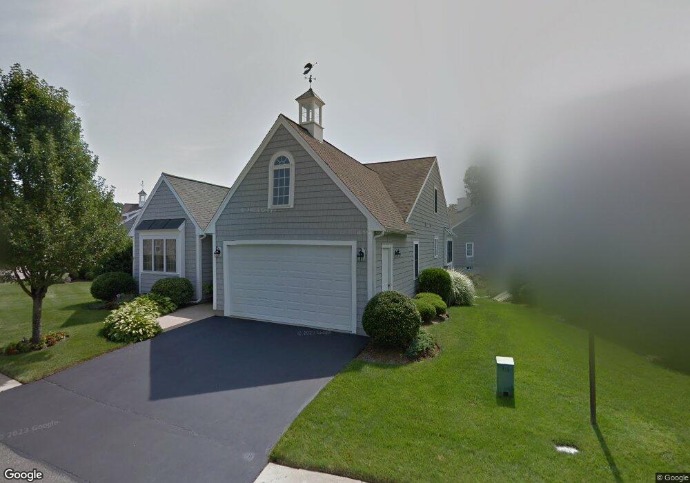
81 Sandtrap Cir South Weymouth, MA 02190
South Weymouth NeighborhoodEstimated Value: $893,748 - $956,000
2
Beds
3
Baths
1,823
Sq Ft
$507/Sq Ft
Est. Value
About This Home
This home is located at 81 Sandtrap Cir, South Weymouth, MA 02190 and is currently estimated at $923,687, approximately $506 per square foot. 81 Sandtrap Cir is a home located in Norfolk County with nearby schools including Thomas W. Hamilton Primary School, Abigail Adams Middle School, and Weymouth Middle School Chapman.
Ownership History
Date
Name
Owned For
Owner Type
Purchase Details
Closed on
May 2, 2022
Sold by
Mcneil Stephen D and Mcneil Janeen M
Bought by
Mcneilfamily 1997 T
Current Estimated Value
Purchase Details
Closed on
Oct 28, 2016
Sold by
Patterson Ft
Bought by
Mcneil Stephen D and Mcneil Janeen M
Purchase Details
Closed on
Dec 15, 2004
Sold by
Patterson Pearl
Bought by
Patterson Ft and Patterson Pearl
Purchase Details
Closed on
Dec 12, 2003
Sold by
Weathervane Dev Corp
Bought by
Patterson Pearl
Create a Home Valuation Report for This Property
The Home Valuation Report is an in-depth analysis detailing your home's value as well as a comparison with similar homes in the area
Home Values in the Area
Average Home Value in this Area
Purchase History
| Date | Buyer | Sale Price | Title Company |
|---|---|---|---|
| Mcneilfamily 1997 T | -- | None Available | |
| Mcneil Stephen D | $510,000 | -- | |
| Patterson Ft | -- | -- | |
| Patterson Pearl | $438,987 | -- |
Source: Public Records
Tax History Compared to Growth
Tax History
| Year | Tax Paid | Tax Assessment Tax Assessment Total Assessment is a certain percentage of the fair market value that is determined by local assessors to be the total taxable value of land and additions on the property. | Land | Improvement |
|---|---|---|---|---|
| 2025 | $8,335 | $825,200 | $0 | $825,200 |
| 2024 | $8,100 | $788,700 | $0 | $788,700 |
| 2023 | $7,116 | $681,000 | $0 | $681,000 |
| 2022 | $7,125 | $621,700 | $0 | $621,700 |
| 2021 | $6,985 | $595,000 | $0 | $595,000 |
| 2020 | $6,782 | $569,000 | $0 | $569,000 |
| 2019 | $6,381 | $526,500 | $0 | $526,500 |
| 2018 | $6,174 | $493,900 | $0 | $493,900 |
| 2017 | $6,209 | $484,700 | $0 | $484,700 |
| 2016 | $6,080 | $475,000 | $0 | $475,000 |
| 2015 | $5,854 | $453,800 | $0 | $453,800 |
| 2014 | $5,934 | $446,200 | $0 | $446,200 |
Source: Public Records
Map
Nearby Homes
- 18 Ben Hogan Landing Unit 18
- 17 Buchanan Ln
- 79 Tilden Rd
- 299 Union St
- 17 Sears Rd
- 26 Leahaven Rd
- 4 Edward Cody Ln
- 102 White St
- 540 Union St
- 25 Wales Ave
- 279 Pine St
- 446 Ralph Talbot St
- 197 White St
- 41 Oak St
- 5 Oak St
- 206 Pine St
- 45 Union St
- 261 Pleasant St Unit 5
- 65 Webster St Unit 401
- 82 Snowbird Ave