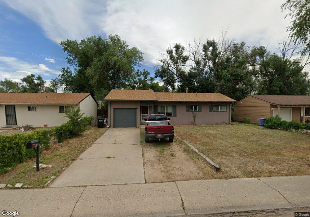
81 Security Blvd Colorado Springs, CO 80911
Fountain Valley Ranch NeighborhoodEstimated Value: $285,000 - $324,000
3
Beds
1
Bath
1,001
Sq Ft
$306/Sq Ft
Est. Value
About This Home
This home is located at 81 Security Blvd, Colorado Springs, CO 80911 and is currently estimated at $306,728, approximately $306 per square foot. 81 Security Blvd is a home located in El Paso County with nearby schools including Venetucci Elementary School, Watson Junior High School, and Widefield High School.
Ownership History
Date
Name
Owned For
Owner Type
Purchase Details
Closed on
Jun 13, 2022
Sold by
Patrick And Sandra Dee Schiferl Trust
Bought by
Pinedo Ana and Chavarin Salvador Pinedo
Current Estimated Value
Home Financials for this Owner
Home Financials are based on the most recent Mortgage that was taken out on this home.
Original Mortgage
$309,294
Outstanding Balance
$294,294
Interest Rate
5.27%
Mortgage Type
FHA
Estimated Equity
$12,434
Purchase Details
Closed on
Nov 2, 2020
Sold by
Schiferl Patrick E and Schiferl Sandra D
Bought by
Patrick And Sandra Dee Schiferl Trust
Purchase Details
Closed on
Apr 1, 1989
Bought by
Schiferl Patrick E and Schiferl Sandra D
Purchase Details
Closed on
Jun 1, 1987
Bought by
Schiferl Patrick E and Schiferl Sandra D
Purchase Details
Closed on
Dec 1, 1985
Bought by
Schiferl Patrick E and Schiferl Sandra D
Create a Home Valuation Report for This Property
The Home Valuation Report is an in-depth analysis detailing your home's value as well as a comparison with similar homes in the area
Home Values in the Area
Average Home Value in this Area
Purchase History
| Date | Buyer | Sale Price | Title Company |
|---|---|---|---|
| Pinedo Ana | $315,000 | None Listed On Document | |
| Patrick And Sandra Dee Schiferl Trust | -- | None Available | |
| Schiferl Patrick E | -- | -- | |
| Schiferl Patrick E | -- | -- | |
| Schiferl Patrick E | -- | -- |
Source: Public Records
Mortgage History
| Date | Status | Borrower | Loan Amount |
|---|---|---|---|
| Open | Pinedo Ana | $309,294 | |
| Closed | Pinedo Ana | $12,371 |
Source: Public Records
Tax History Compared to Growth
Tax History
| Year | Tax Paid | Tax Assessment Tax Assessment Total Assessment is a certain percentage of the fair market value that is determined by local assessors to be the total taxable value of land and additions on the property. | Land | Improvement |
|---|---|---|---|---|
| 2025 | $1,324 | $21,640 | -- | -- |
| 2024 | $1,324 | $21,640 | $3,220 | $18,420 |
| 2023 | $1,259 | $21,640 | $3,220 | $18,420 |
| 2022 | $1,029 | $13,790 | $2,220 | $11,570 |
| 2021 | $1,110 | $14,190 | $2,290 | $11,900 |
| 2020 | $793 | $9,840 | $2,000 | $7,840 |
| 2019 | $788 | $9,840 | $2,000 | $7,840 |
| 2018 | $700 | $8,160 | $1,500 | $6,660 |
| 2017 | $708 | $8,160 | $1,500 | $6,660 |
| 2016 | $552 | $7,770 | $1,590 | $6,180 |
| 2015 | $566 | $7,770 | $1,590 | $6,180 |
| 2014 | $520 | $7,170 | $1,430 | $5,740 |
Source: Public Records
Map
Nearby Homes
- 89 Security Blvd
- 102 Security Blvd
- 99 Security Blvd
- 101 Security Blvd
- 141 Hayes Dr
- 80 Landoe Ln
- 95 Landoe Ln
- 409 Kiva Rd
- 6380 Southmoor Dr
- 102 Landoe Ln
- 128 Amherst St
- 345 Libby Ct
- 576 Lindstrom Dr
- 1358 Luna Dr
- 490 Dix Cir
- 1375 Luna Dr
- 817 Grand Blvd
- 115 Widefield Blvd
- 1 N Dartmouth St
- 110 Dartmouth St