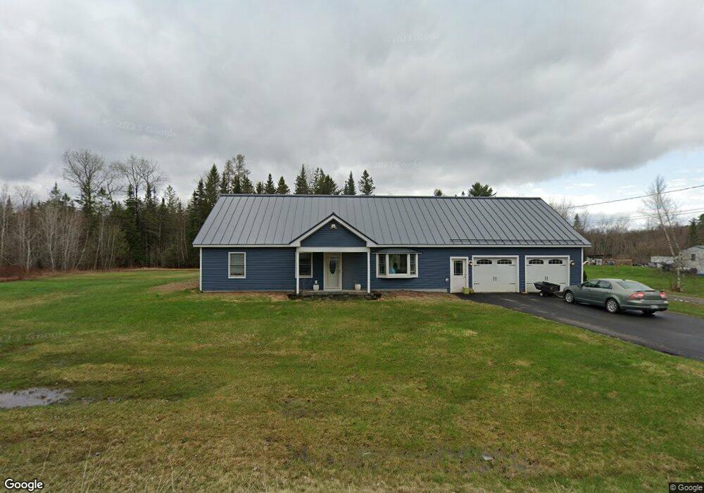
81 Whitten Rd Canaan, ME 04924
Estimated Value: $207,000 - $384,000
2
Beds
2
Baths
924
Sq Ft
$329/Sq Ft
Est. Value
About This Home
This home is located at 81 Whitten Rd, Canaan, ME 04924 and is currently estimated at $303,609, approximately $328 per square foot. 81 Whitten Rd is a home located in Somerset County.
Ownership History
Date
Name
Owned For
Owner Type
Purchase Details
Closed on
Mar 28, 2016
Sold by
Lambert Charles D
Bought by
Rollins Shanda
Current Estimated Value
Home Financials for this Owner
Home Financials are based on the most recent Mortgage that was taken out on this home.
Original Mortgage
$163,875
Outstanding Balance
$130,317
Interest Rate
3.71%
Estimated Equity
$173,292
Purchase Details
Closed on
Sep 8, 2015
Sold by
Rollins Shanda L and Rollins Jason A
Bought by
Rollins Jason A and Lambert Charles D
Purchase Details
Closed on
Jul 2, 2015
Sold by
Rollins Thomas M and Rollins Bettyjean D
Bought by
Rollins Jason A and Smith-Rollins Shanda L
Purchase Details
Closed on
Sep 18, 2009
Sold by
Miller Frances A Est and Lee Elsie J
Bought by
Rollins Thomas M and Rollins Bettyjean D
Home Financials for this Owner
Home Financials are based on the most recent Mortgage that was taken out on this home.
Original Mortgage
$30,000
Interest Rate
5.28%
Mortgage Type
Purchase Money Mortgage
Create a Home Valuation Report for This Property
The Home Valuation Report is an in-depth analysis detailing your home's value as well as a comparison with similar homes in the area
Home Values in the Area
Average Home Value in this Area
Purchase History
| Date | Buyer | Sale Price | Title Company |
|---|---|---|---|
| Rollins Shanda | -- | -- | |
| Rollins Jason A | -- | -- | |
| Rollins Jason A | -- | -- | |
| Rollins Thomas M | -- | -- |
Source: Public Records
Mortgage History
| Date | Status | Borrower | Loan Amount |
|---|---|---|---|
| Open | Rollins Shanda | $163,875 | |
| Closed | Rollins Shanda | -- | |
| Previous Owner | Rollins Thomas M | $30,000 |
Source: Public Records
Tax History Compared to Growth
Tax History
| Year | Tax Paid | Tax Assessment Tax Assessment Total Assessment is a certain percentage of the fair market value that is determined by local assessors to be the total taxable value of land and additions on the property. | Land | Improvement |
|---|---|---|---|---|
| 2024 | $2,985 | $281,600 | $41,200 | $240,400 |
| 2023 | $2,352 | $123,800 | $23,300 | $100,500 |
| 2022 | $2,043 | $123,800 | $23,300 | $100,500 |
| 2021 | $2,179 | $123,800 | $23,300 | $100,500 |
| 2020 | $2,105 | $123,800 | $23,300 | $100,500 |
| 2019 | $2,092 | $123,800 | $23,300 | $100,500 |
| 2018 | $2,018 | $123,800 | $23,300 | $100,500 |
| 2017 | $1,894 | $123,800 | $23,300 | $100,500 |
| 2016 | $1,776 | $122,500 | $23,300 | $99,200 |
| 2015 | $609 | $38,800 | $23,300 | $15,500 |
| 2014 | $621 | $38,800 | $23,300 | $15,500 |
| 2013 | -- | $38,800 | $23,300 | $15,500 |
Source: Public Records
Map
Nearby Homes
- 13 Aspen Ln
- 1107 Hill Rd
- Lot 52 Ella Gerald Rd
- 376 Battle Ridge Rd
- TBD Hillside Dr
- 648 Battle Ridge Rd
- 10 Bush Rd
- 910 Mutton Ln
- Lot31 Johnson Flat Rd
- 777 Hinckley Rd
- 22 Tobey Rd
- 451 Johnson Flat Rd
- 385 Johnson Flat Rd
- 289 Main St
- 236 Main St
- 420 Main St
- TBD Mutton Ln
- 62 Pine Valley Dr
- Lot 7 Oak Pond Rd
- Lot 6 Oak Pond Rd