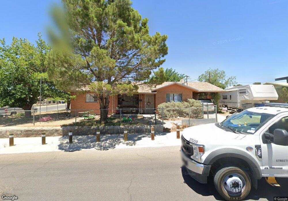
8101 Burnham Rd El Paso, TX 79907
Mesa Vista NeighborhoodEstimated Value: $149,000 - $188,000
--
Bed
2
Baths
1,170
Sq Ft
$138/Sq Ft
Est. Value
About This Home
This home is located at 8101 Burnham Rd, El Paso, TX 79907 and is currently estimated at $161,691, approximately $138 per square foot. 8101 Burnham Rd is a home located in El Paso County with nearby schools including Bel Air Middle, Bel Air High School, and Premier High School Of El Paso.
Ownership History
Date
Name
Owned For
Owner Type
Purchase Details
Closed on
Aug 16, 2010
Sold by
Deucher Celia T and Deucher Ronald
Bought by
Deucher Celia T
Current Estimated Value
Purchase Details
Closed on
Apr 21, 1998
Sold by
Deucher Ronald Dean
Bought by
Deucher Celia
Home Financials for this Owner
Home Financials are based on the most recent Mortgage that was taken out on this home.
Original Mortgage
$41,779
Interest Rate
7.23%
Create a Home Valuation Report for This Property
The Home Valuation Report is an in-depth analysis detailing your home's value as well as a comparison with similar homes in the area
Home Values in the Area
Average Home Value in this Area
Purchase History
| Date | Buyer | Sale Price | Title Company |
|---|---|---|---|
| Deucher Celia T | -- | None Available | |
| Deucher Celia | -- | -- |
Source: Public Records
Mortgage History
| Date | Status | Borrower | Loan Amount |
|---|---|---|---|
| Closed | Deucher Celia | $41,779 |
Source: Public Records
Tax History Compared to Growth
Tax History
| Year | Tax Paid | Tax Assessment Tax Assessment Total Assessment is a certain percentage of the fair market value that is determined by local assessors to be the total taxable value of land and additions on the property. | Land | Improvement |
|---|---|---|---|---|
| 2025 | -- | $136,859 | -- | -- |
| 2024 | -- | $124,417 | -- | -- |
| 2023 | $3,292 | $113,106 | $0 | $0 |
| 2022 | $3,193 | $102,824 | $0 | $0 |
| 2021 | $3,038 | $93,953 | $14,406 | $79,547 |
| 2020 | $2,684 | $84,978 | $14,406 | $70,572 |
| 2018 | $2,623 | $84,334 | $14,406 | $69,928 |
| 2017 | $2,619 | $85,665 | $14,406 | $71,259 |
| 2016 | $2,619 | $85,665 | $14,406 | $71,259 |
| 2015 | -- | $85,665 | $14,406 | $71,259 |
| 2014 | -- | $86,505 | $14,406 | $72,099 |
Source: Public Records
Map
Nearby Homes
- 1121 Stanley St
- 8004 Gilbert Dr
- TBD Burnham Dr
- 8241 Williamette Ave
- 1004 Atwood Dr
- 7975 Esther Rd
- 8341 Loma Terrace Rd
- 740 Draco Place
- 7937 San Paulo Dr
- 956 Duskin Dr
- 7928 Hermosillo Dr
- TBD Yermoland Dr
- 7922 Parral Dr
- 8181 Staghorn Dr
- 10844 Sombra Verde Dr
- 1-12 Vanderbilt Dr
- 812 Santa Barbara Dr
- 844 Santa Barbara Dr
- 10617 Candlewood Ave
- 7800 Hermosillo Dr
- 1206 Stanley St
- 8100 Burnham Rd
- 1210 Stanley St
- 8105 Burnham Rd
- 1205 Stanley St
- 1201 Stanley St
- 8106 Gilbert Dr
- 8108 Gilbert Dr
- 8104 Burnham Rd
- 1209 Stanley St
- 8100 Gilbert Dr
- 8112 Gilbert Dr
- 8109 Burnham Rd
- 1215 Stanley St
- 8108 Burnham Rd
- 1165 Stanley St
- 8116 Gilbert Dr
- 8063 Glendale Ave
- 8101 Loma Terrace Rd
- 1219 Stanley St