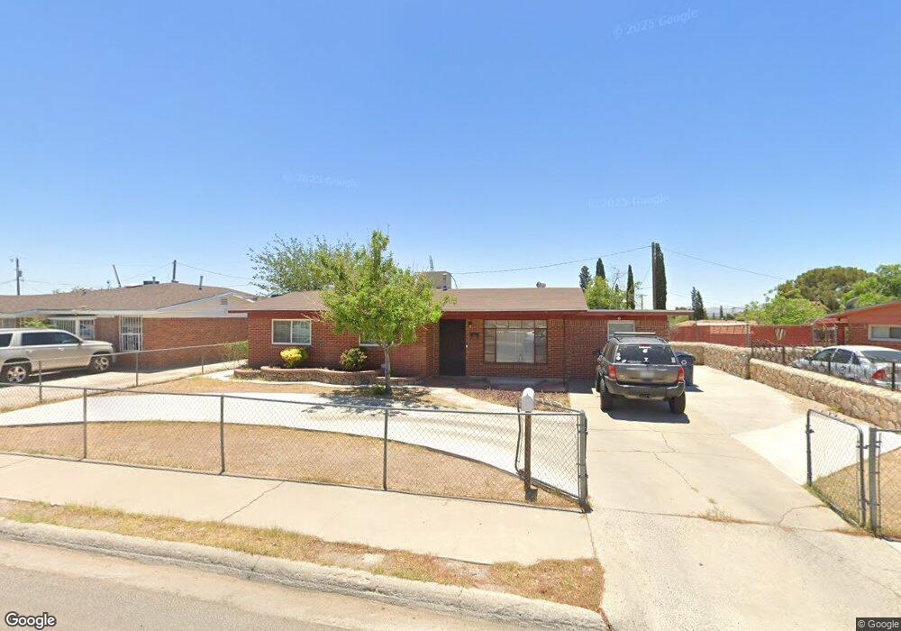
8104 Burnham Rd El Paso, TX 79907
Mesa Vista NeighborhoodEstimated Value: $162,000 - $218,000
Studio
2
Baths
1,202
Sq Ft
$148/Sq Ft
Est. Value
About This Home
This home is located at 8104 Burnham Rd, El Paso, TX 79907 and is currently estimated at $178,087, approximately $148 per square foot. 8104 Burnham Rd is a home located in El Paso County with nearby schools including Bel Air Middle, Bel Air High School, and El Paso Classical Academy.
Ownership History
Date
Name
Owned For
Owner Type
Purchase Details
Closed on
May 21, 2011
Sold by
Franco Steve
Bought by
Aguirre Jessica Lynn
Current Estimated Value
Purchase Details
Closed on
Mar 28, 2005
Sold by
Franco Cynthia Ann
Bought by
Franco Rebecca Lynn
Purchase Details
Closed on
Mar 25, 2005
Sold by
Franco Steven
Bought by
Franco Rebecca Lynn
Purchase Details
Closed on
Apr 25, 2001
Sold by
Franco Asuncion Joaquin and Franco Asuncion J
Bought by
Franco Vera M
Purchase Details
Closed on
Feb 26, 1999
Sold by
Franco Asuncion Joaquin
Bought by
Franco Vera M
Create a Home Valuation Report for This Property
The Home Valuation Report is an in-depth analysis detailing your home's value as well as a comparison with similar homes in the area
Home Values in the Area
Average Home Value in this Area
Purchase History
| Date | Buyer | Sale Price | Title Company |
|---|---|---|---|
| Aguirre Jessica Lynn | -- | None Available | |
| Franco Rebecca Lynn | -- | -- | |
| Franco Rebecca Lynn | -- | -- | |
| Franco Rebecca Lynn | -- | -- | |
| Franco Rebecca Lynn | -- | -- | |
| Franco Vera M | -- | -- | |
| Franco Vera M | -- | -- |
Source: Public Records
Tax History
| Year | Tax Paid | Tax Assessment Tax Assessment Total Assessment is a certain percentage of the fair market value that is determined by local assessors to be the total taxable value of land and additions on the property. | Land | Improvement |
|---|---|---|---|---|
| 2025 | $1,965 | $144,291 | -- | -- |
| 2024 | $1,965 | $131,174 | -- | -- |
| 2023 | $1,879 | $119,249 | $0 | $0 |
| 2022 | $3,366 | $108,408 | $0 | $0 |
| 2021 | $3,203 | $98,926 | $14,725 | $84,201 |
| 2020 | $2,830 | $89,594 | $14,725 | $74,869 |
| 2018 | $2,765 | $88,903 | $14,725 | $74,178 |
| 2017 | $2,747 | $89,865 | $14,725 | $75,140 |
| 2016 | $2,747 | $89,865 | $14,725 | $75,140 |
| 2015 | $2,078 | $89,865 | $14,725 | $75,140 |
| 2014 | $2,078 | $90,354 | $14,725 | $75,629 |
Source: Public Records
Map
Nearby Homes
- 8144 Burnham Rd
- 8045 Gilbert Dr
- 1101 Doyle Place
- 1037 Stanley St
- 1004 Atwood Dr
- 628 N Yarbrough Dr
- 961 Wyatt Dr
- 965 Duskin Dr
- 632 Mauer Dr
- 945 Richard Dr
- 964 Lomita Dr
- TBD Yermoland Dr
- 653 Lafayette Dr
- 7863 Laura Way
- 7906 Santa Maria Ct
- 1-12 Vanderbilt Dr
- 7973 Heid Ave
- 533 Montecito Rd
- 7860 Holly Place
- 7800 Hermosillo Dr
- 8108 Burnham Rd
- 8100 Burnham Rd
- 8101 Loma Terrace Rd
- 8112 Burnham Rd
- 8105 Burnham Rd
- 8105 Loma Terrace Rd
- 8109 Burnham Rd
- 8101 Burnham Rd
- 8103 Burnham Rd
- 8116 Burnham Rd
- 8113 Burnham Rd
- 8109 Loma Terrace Rd
- 1165 Stanley St
- 1206 Stanley St
- 1161 Stanley St
- 1201 Stanley St
- 8112 Gilbert Dr
- 8116 Gilbert Dr
- 8117 Burnham Rd
- 8108 Gilbert Dr
Your Personal Tour Guide
Ask me questions while you tour the home.