Estimated Value: $271,799 - $315,000
3
Beds
2
Baths
1,684
Sq Ft
$177/Sq Ft
Est. Value
About This Home
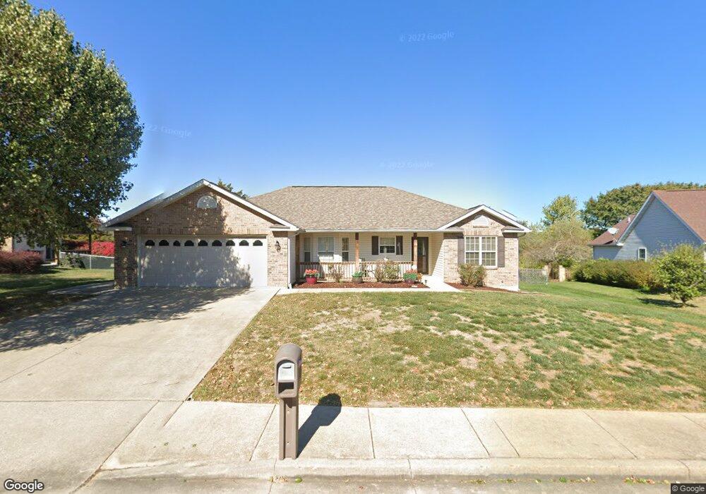
This home is located at 811 Cambridge Dr, Rolla, MO 65401 and is currently estimated at $297,600, approximately $176 per square foot. 811 Cambridge Dr is a home located in Phelps County with nearby schools including Rolla Junior High School, Rolla Senior High School, and Rolla Seventh-Day Adventist School.
Ownership History
Date
Name
Owned For
Owner Type
Purchase Details
Closed on
Jan 22, 2025
Sold by
Burns Leslie L
Bought by
Moore Kreig L
Current Estimated Value
Home Financials for this Owner
Home Financials are based on the most recent Mortgage that was taken out on this home.
Original Mortgage
$254,600
Outstanding Balance
$247,576
Interest Rate
0.69%
Mortgage Type
Construction
Estimated Equity
$50,024
Purchase Details
Closed on
Jun 30, 2017
Bought by
Burns Glenda C
Create a Home Valuation Report for This Property
The Home Valuation Report is an in-depth analysis detailing your home's value as well as a comparison with similar homes in the area
Home Values in the Area
Average Home Value in this Area
Purchase History
| Date | Buyer | Sale Price | Title Company |
|---|---|---|---|
| Moore Kreig L | $318,250 | Wiggins Abs Co | |
| Burns Glenda C | -- | -- |
Source: Public Records
Mortgage History
| Date | Status | Borrower | Loan Amount |
|---|---|---|---|
| Open | Moore Kreig L | $254,600 |
Source: Public Records
Tax History
| Year | Tax Paid | Tax Assessment Tax Assessment Total Assessment is a certain percentage of the fair market value that is determined by local assessors to be the total taxable value of land and additions on the property. | Land | Improvement |
|---|---|---|---|---|
| 2025 | $1,741 | $33,370 | $5,230 | $28,140 |
| 2024 | $1,605 | $29,860 | $4,280 | $25,580 |
| 2023 | $1,615 | $29,860 | $4,280 | $25,580 |
| 2022 | $1,372 | $29,860 | $4,280 | $25,580 |
| 2021 | $1,381 | $29,860 | $4,280 | $25,580 |
| 2020 | $1,257 | $26,520 | $4,280 | $22,240 |
| 2019 | $1,250 | $26,520 | $4,280 | $22,240 |
| 2018 | $1,239 | $26,520 | $4,280 | $22,240 |
| 2017 | $1,237 | $26,520 | $4,280 | $22,240 |
| 2016 | $1,178 | $26,110 | $4,280 | $21,830 |
| 2015 | -- | $26,110 | $4,280 | $21,830 |
| 2014 | -- | $26,110 | $4,280 | $21,830 |
| 2013 | -- | $26,110 | $0 | $0 |
Source: Public Records
Map
Nearby Homes
- 814 Oxford Dr
- 821 Cambridge Dr
- 816 Laurel Dr
- 403 Hutchinson Dr
- 807 Lariat Ln
- Lot 74 B Cedar Hill Ct
- Lot 74 A Cedar Hill Ct
- 1102 Sycamore Dr
- 708 E State Route 72
- 503 Lariat Ln
- 687 Salem Ave
- 213 Sunny Dr
- 35 Green Acres Dr
- 1132 Leonard Ave
- 654 Holmes Ln
- 63 Rose Ct
- 233 Sunny Dr
- 38 Johnson Dr
- 56 Rolla Gardens Dr
- 5 Rolla Gardens Dr
- 813 Cambridge Dr
- 812 Oxford Dr
- 810 Oxford Dr
- 808 Oxford Dr
- 807 Cambridge Dr
- 815 Cambridge Dr
- 810 Cambridge Dr
- 808 Cambridge Dr
- 816 Oxford Dr
- 812 Cambridge Dr
- 806 Oxford Dr
- 806 Cambridge Dr
- 805 Cambridge Dr
- 817 Cambridge Dr
- 818 Oxford Dr
- 814 Cambridge Dr
- 804 Oxford Dr
- 817 Oxford Dr
- 611 Norwich Dr
- 613 Norwich Dr
Your Personal Tour Guide
Ask me questions while you tour the home.