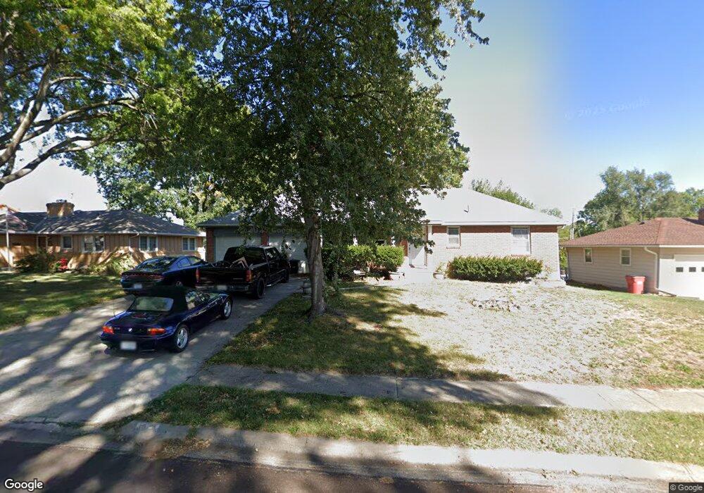
811 N Pawnee Ave Independence, MO 64056
Randall NeighborhoodEstimated Value: $190,000 - $217,000
2
Beds
2
Baths
1,008
Sq Ft
$200/Sq Ft
Est. Value
About This Home
This home is located at 811 N Pawnee Ave, Independence, MO 64056 and is currently estimated at $202,083, approximately $200 per square foot. 811 N Pawnee Ave is a home located in Jackson County with nearby schools including Randall Elementary School, Bridger Middle School, and Bingham Middle School.
Ownership History
Date
Name
Owned For
Owner Type
Purchase Details
Closed on
Mar 25, 2022
Sold by
Anna Larsen Lee and Anna Carl E
Bought by
Goodwin Robert and Goodwin Mindy Lynn
Current Estimated Value
Purchase Details
Closed on
May 19, 2017
Sold by
Titus Thomas Edward and Titus Susan R
Bought by
Larsen Leeanna and Larsen Carl E
Purchase Details
Closed on
Jun 9, 2000
Sold by
Vetter Douglas M
Bought by
Vetter Lee Anna
Purchase Details
Closed on
Oct 7, 1998
Sold by
Tumlinson Harry J and Tumlinson Della M
Bought by
Vetter Lee Anna and Titus Thomas E
Create a Home Valuation Report for This Property
The Home Valuation Report is an in-depth analysis detailing your home's value as well as a comparison with similar homes in the area
Home Values in the Area
Average Home Value in this Area
Purchase History
| Date | Buyer | Sale Price | Title Company |
|---|---|---|---|
| Goodwin Robert | -- | First American Title | |
| Goodwin Robert | -- | First American Title | |
| Larsen Leeanna | -- | None Available | |
| Vetter Lee Anna | -- | -- | |
| Vetter Lee Anna | -- | -- |
Source: Public Records
Tax History Compared to Growth
Tax History
| Year | Tax Paid | Tax Assessment Tax Assessment Total Assessment is a certain percentage of the fair market value that is determined by local assessors to be the total taxable value of land and additions on the property. | Land | Improvement |
|---|---|---|---|---|
| 2025 | $1,758 | $29,184 | $5,713 | $23,471 |
| 2024 | $1,718 | $25,378 | $3,297 | $22,081 |
| 2023 | $1,718 | $25,379 | $2,932 | $22,447 |
| 2022 | $1,895 | $25,650 | $4,898 | $20,752 |
| 2021 | $1,894 | $25,650 | $4,898 | $20,752 |
| 2020 | $1,735 | $22,835 | $4,898 | $17,937 |
| 2019 | $1,707 | $22,835 | $4,898 | $17,937 |
| 2018 | $1,557 | $19,874 | $4,263 | $15,611 |
| 2017 | $1,557 | $19,874 | $4,263 | $15,611 |
| 2016 | $1,533 | $19,375 | $3,718 | $15,657 |
| 2014 | $1,456 | $18,811 | $3,610 | $15,201 |
Source: Public Records
Map
Nearby Homes
- 813 N Pawnee Ave
- 801 N Redwood Dr
- 17501 E Cheyenne Dr
- 17315 E 6th Terrace Ct N
- 17611 E Susquehanna Dr
- 0 Bundschu Rd Unit HMS2577360
- 802 N Ute St
- 18000 E Dakota Dr
- 1201 N Indian Ln
- 18001 E 12th St N
- 18100 E 11th Terrace Ct N
- 1104 N Viking Dr
- 1310 N Indian Ln
- 18507 E Bundschu Place
- 1124 N Ponca Dr
- 915 N Cochise Ave
- 18400 E Arrowhead Ln
- 16104 E Cogan Ln
- 17008 E Salisbury Rd
- 320 N M 291 Hwy
- 809 N Pawnee Ave
- 810 N Dakota Dr
- 810 N Pawnee Ave
- 808 N Pawnee Ave
- 812 N Dakota Dr
- 807 N Pawnee Ave
- 812 N Pawnee Ave
- 808 N Dakota Dr
- 806 N Pawnee Ave
- 805 N Pawnee Ave
- 806 N Dakota Dr
- 804 N Pawnee Ave
- 17314 E Susquehanna Dr
- 811 N Dakota Dr
- 809 N Dakota Dr
- 813 N Crow Ave
- 803 N Pawnee Ave
- 811 N Crow Ave
- 809 N Crow Ave
- 807 N Crow Ave