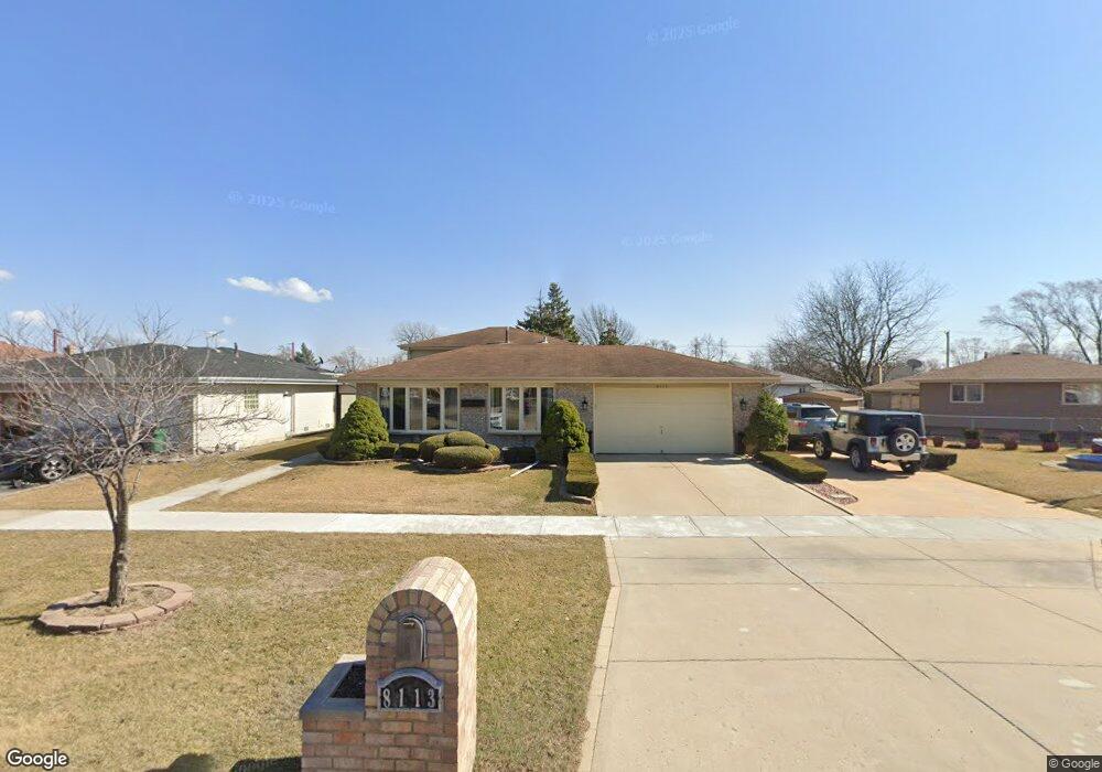
8113 State Rd Burbank, IL 60459
Estimated Value: $352,000 - $482,000
3
Beds
3
Baths
1,339
Sq Ft
$295/Sq Ft
Est. Value
About This Home
This home is located at 8113 State Rd, Burbank, IL 60459 and is currently estimated at $395,216, approximately $295 per square foot. 8113 State Rd is a home located in Cook County with nearby schools including Luther Burbank Elementary School, Reavis High School, and St Albert the Great Catholic School.
Ownership History
Date
Name
Owned For
Owner Type
Purchase Details
Closed on
Oct 13, 1993
Sold by
Chicago City Bank & Trust Company
Bought by
Rodriguez Luis and Rodriguez Cedelia
Current Estimated Value
Home Financials for this Owner
Home Financials are based on the most recent Mortgage that was taken out on this home.
Original Mortgage
$123,000
Interest Rate
6.92%
Create a Home Valuation Report for This Property
The Home Valuation Report is an in-depth analysis detailing your home's value as well as a comparison with similar homes in the area
Home Values in the Area
Average Home Value in this Area
Purchase History
| Date | Buyer | Sale Price | Title Company |
|---|---|---|---|
| Rodriguez Luis | $109,000 | -- |
Source: Public Records
Mortgage History
| Date | Status | Borrower | Loan Amount |
|---|---|---|---|
| Closed | Rodriguez Luis | $123,000 |
Source: Public Records
Tax History
| Year | Tax Paid | Tax Assessment Tax Assessment Total Assessment is a certain percentage of the fair market value that is determined by local assessors to be the total taxable value of land and additions on the property. | Land | Improvement |
|---|---|---|---|---|
| 2025 | $8,388 | $33,000 | $5,679 | $27,321 |
| 2024 | $8,388 | $33,000 | $5,679 | $27,321 |
| 2023 | $4,346 | $33,000 | $5,679 | $27,321 |
| 2022 | $4,346 | $24,761 | $4,998 | $19,763 |
| 2021 | $4,049 | $24,760 | $4,997 | $19,763 |
| 2020 | $3,639 | $24,760 | $4,997 | $19,763 |
| 2019 | $4,049 | $24,737 | $4,543 | $20,194 |
| 2018 | $3,940 | $24,737 | $4,543 | $20,194 |
| 2017 | $3,743 | $24,737 | $4,543 | $20,194 |
| 2016 | $4,896 | $20,072 | $3,861 | $16,211 |
| 2015 | $4,951 | $20,072 | $3,861 | $16,211 |
| 2014 | $4,552 | $20,072 | $3,861 | $16,211 |
| 2013 | $4,398 | $19,139 | $3,861 | $15,278 |
Source: Public Records
Map
Nearby Homes
- 5831 W 81st Place
- 8254 Linder Ave
- 5640 W 84th St
- 7843 Massasoit Ave
- 5822 W 79th St
- 5500 W 83rd Place
- 7814 Major Ave
- 8033 Austin Ave
- 7807 Parkside Ave
- 7808 Central Ave
- 7836 Monitor Ave
- 8121 Mcvicker Ave
- 5610 W 85th St
- 6117 W 81st St
- 5834 W 77th St Unit 104
- 7827 Meade Ave
- 6124 W 79th St
- 7851 Moody Ave
- 5242 W 79th St Unit 3D
- 7948 Merrimac Ave
- 8109 State Rd
- 5640 W 81st Place
- 5644 W 81st Place
- 5636 W 81st Place
- 8105 State Rd
- 5648 81st Place
- 5632 W 81st Place
- 5641 W 81st St
- 8101 State Rd
- 5628 W 81st Place
- 5704 W 81st St
- 5645 W 81st St
- 5619 W 81st Place
- 5624 W 81st Place
- 5629 W 81st Place
- 8044 Major Ave
- 5635 W 81st Place
- 8039 Massasoit Ave
- 5627 W 81st Place
- 5701 W 81st St
Your Personal Tour Guide
Ask me questions while you tour the home.