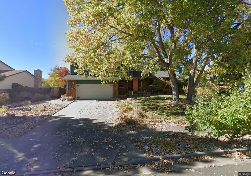
812 Altair Dr Lone Tree, CO 80124
Estimated Value: $595,000 - $671,040
4
Beds
3
Baths
2,812
Sq Ft
$225/Sq Ft
Est. Value
About This Home
This home is located at 812 Altair Dr, Lone Tree, CO 80124 and is currently estimated at $632,510, approximately $224 per square foot. 812 Altair Dr is a home located in Douglas County with nearby schools including Acres Green Elementary School, Cresthill Middle School, and Highlands Ranch High School.
Ownership History
Date
Name
Owned For
Owner Type
Purchase Details
Closed on
Jun 22, 2018
Sold by
Barrett Scott R Barrett and Barrett Heather A
Bought by
Cannon Ava L and Nelson Dave P
Current Estimated Value
Home Financials for this Owner
Home Financials are based on the most recent Mortgage that was taken out on this home.
Original Mortgage
$364,800
Outstanding Balance
$315,491
Interest Rate
4.5%
Mortgage Type
New Conventional
Estimated Equity
$317,019
Purchase Details
Closed on
Aug 24, 2001
Sold by
Reynolds Steven J and Reynolds Angela M
Bought by
Barrett Scott R and Barrett Heather A
Home Financials for this Owner
Home Financials are based on the most recent Mortgage that was taken out on this home.
Original Mortgage
$229,261
Interest Rate
7.16%
Mortgage Type
FHA
Purchase Details
Closed on
Aug 30, 1995
Sold by
Pitrone Kim and Pitrone Philip G
Bought by
Reynolds Steven J and Reynolds Angela M
Home Financials for this Owner
Home Financials are based on the most recent Mortgage that was taken out on this home.
Original Mortgage
$136,350
Interest Rate
7.76%
Purchase Details
Closed on
May 21, 1991
Sold by
Hodgers Harry J and Hodgers Marleen C
Bought by
Pitrone Philip G and Pitrone Kim
Purchase Details
Closed on
Nov 10, 1976
Sold by
Unavailable
Bought by
Unavailable
Create a Home Valuation Report for This Property
The Home Valuation Report is an in-depth analysis detailing your home's value as well as a comparison with similar homes in the area
Home Values in the Area
Average Home Value in this Area
Purchase History
| Date | Buyer | Sale Price | Title Company |
|---|---|---|---|
| Cannon Ava L | $456,000 | None Available | |
| Barrett Scott R | $232,500 | Land Title | |
| Reynolds Steven J | $151,500 | -- | |
| Pitrone Philip G | $94,900 | -- | |
| Unavailable | $50,700 | -- |
Source: Public Records
Mortgage History
| Date | Status | Borrower | Loan Amount |
|---|---|---|---|
| Open | Cannon Ava L | $364,800 | |
| Previous Owner | Barrett Scott R | $229,261 | |
| Previous Owner | Reynolds Steven J | $136,350 |
Source: Public Records
Tax History Compared to Growth
Tax History
| Year | Tax Paid | Tax Assessment Tax Assessment Total Assessment is a certain percentage of the fair market value that is determined by local assessors to be the total taxable value of land and additions on the property. | Land | Improvement |
|---|---|---|---|---|
| 2024 | $3,752 | $44,570 | $8,140 | $36,430 |
| 2023 | $3,790 | $44,570 | $8,140 | $36,430 |
| 2022 | $2,785 | $31,280 | $6,910 | $24,370 |
| 2021 | $2,897 | $31,280 | $6,910 | $24,370 |
| 2020 | $2,765 | $30,590 | $6,540 | $24,050 |
| 2019 | $2,774 | $30,590 | $6,540 | $24,050 |
| 2018 | $2,108 | $24,890 | $5,690 | $19,200 |
| 2017 | $2,142 | $24,890 | $5,690 | $19,200 |
| 2016 | $1,916 | $21,800 | $4,100 | $17,700 |
| 2015 | $980 | $21,800 | $4,100 | $17,700 |
| 2014 | $880 | $18,340 | $3,980 | $14,360 |
Source: Public Records
Map
Nearby Homes
- 13678 Omega Cir
- 7057 Chestnut Hill St
- 202 Helena Cir
- 979 Mercury Cir
- 789 Hamal Dr
- 426 Jupiter Dr
- 7041 Chestnut Hill Trail
- 13134 Deneb Dr
- 336 Aquarius Ct
- 383 Helena Cir
- 250 Jupiter Dr
- 13542 Achilles Dr
- 7971 Arrowhead Ct
- 13483 Achilles Dr
- 181 Dianna Dr
- 7920 E Phillips Cir
- 8049 Sweet Water Rd
- 7976 E Phillips Cir
- 8159 Lodgepole Trail
- 9275 Erminedale Dr