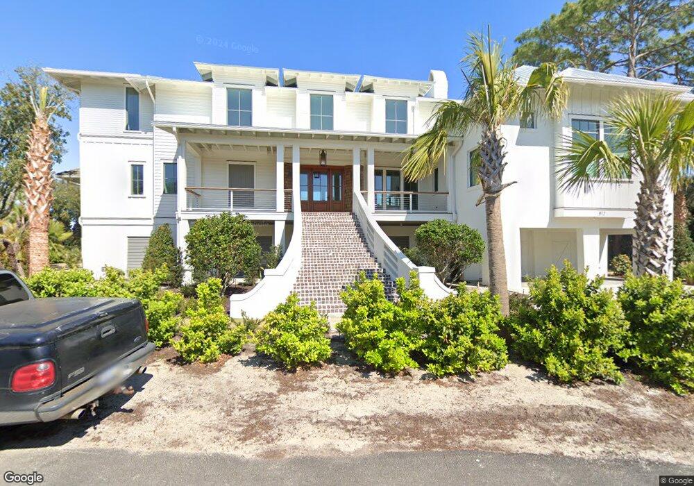
812 Conquest Ave Unit 29482 Sullivans Island, SC 29482
Sullivan's Island NeighborhoodEstimated Value: $4,744,000 - $8,494,071
3
Beds
3
Baths
3,154
Sq Ft
$2,235/Sq Ft
Est. Value
About This Home
This home is located at 812 Conquest Ave Unit 29482, Sullivans Island, SC 29482 and is currently estimated at $7,049,357, approximately $2,235 per square foot. 812 Conquest Ave Unit 29482 is a home located in Charleston County with nearby schools including Sullivans Island Elementary School, Moultrie Middle School, and Wando High School.
Ownership History
Date
Name
Owned For
Owner Type
Purchase Details
Closed on
Feb 9, 2023
Sold by
Simmons Construction Of Charleston Llc
Bought by
Foxcroft Equity Llc
Current Estimated Value
Purchase Details
Closed on
Oct 5, 2020
Sold by
Old Blue Development Llc
Bought by
Simmons Construction Of Charleston Llc
Purchase Details
Closed on
Feb 11, 2016
Sold by
Tyroler Merle J
Bought by
Old Blue Development Llc
Create a Home Valuation Report for This Property
The Home Valuation Report is an in-depth analysis detailing your home's value as well as a comparison with similar homes in the area
Home Values in the Area
Average Home Value in this Area
Purchase History
| Date | Buyer | Sale Price | Title Company |
|---|---|---|---|
| Foxcroft Equity Llc | -- | -- | |
| Foxcroft Equity Llc | $8,700,000 | -- | |
| Simmons Construction Of Charleston Llc | -- | None Available | |
| Simmons Construction Of Charleston Llc | $3,100,000 | None Available | |
| Old Blue Development Llc | -- | -- | |
| Old Blue Development Llc | $2,900,000 | -- |
Source: Public Records
Tax History Compared to Growth
Tax History
| Year | Tax Paid | Tax Assessment Tax Assessment Total Assessment is a certain percentage of the fair market value that is determined by local assessors to be the total taxable value of land and additions on the property. | Land | Improvement |
|---|---|---|---|---|
| 2024 | $133,837 | $465,000 | $0 | $0 |
| 2023 | $48,229 | $186,000 | $0 | $0 |
| 2022 | $46,796 | $186,000 | $0 | $0 |
| 2021 | $46,046 | $186,000 | $0 | $0 |
| 2020 | $43,896 | $180,000 | $0 | $0 |
| 2019 | $43,200 | $139,200 | $0 | $0 |
| 2017 | $24,523 | $107,230 | $0 | $0 |
| 2016 | $6,898 | $71,490 | $0 | $0 |
| 2015 | $7,205 | $71,490 | $0 | $0 |
| 2014 | $5,580 | $0 | $0 | $0 |
| 2011 | -- | $0 | $0 | $0 |
Source: Public Records
Map
Nearby Homes
- 3 Pierates Cruz
- 721 Royall Ave
- 551 Klein St
- 558 Center St
- 1714 Middle St
- 1651 Atlantic Ave
- 731 Pitt St
- 657 Gate Post Dr
- 695 Gate Post Dr
- 1749 Middle St
- 1727 Atlantic Ave
- 1666 Marsh Harbor Ln Unit 101
- 1647 Marsh Harbor Ln
- 1750 Ion Ave
- 1504 Old Village Dr
- 1489 Kinloch Ln
- 780 Post Oak Dr
- 670 Poaug Ln
- 1608 Marsh Harbor Ln Unit C
- 1606 Marsh Harbor Ln Unit C
- 812 Conquest Ave
- 813 Conquest Ave
- 7 Conquest Ave
- 3 Conquest Ave
- 6 Conquest Ave
- 828 Middle St
- 816 Conquest Ave
- 815 Conquest Ave
- 813 Middle St
- 808 Star of the St
- 810 Star of the St W
- 836 Middle St
- 823 Middle St
- 806 Star of the West St
- 806 Star of the St
- 840 Middle St
- 829 Middle St
- 5 Conquest Ave
- 801 Star of the West St
- 804 Star of the St