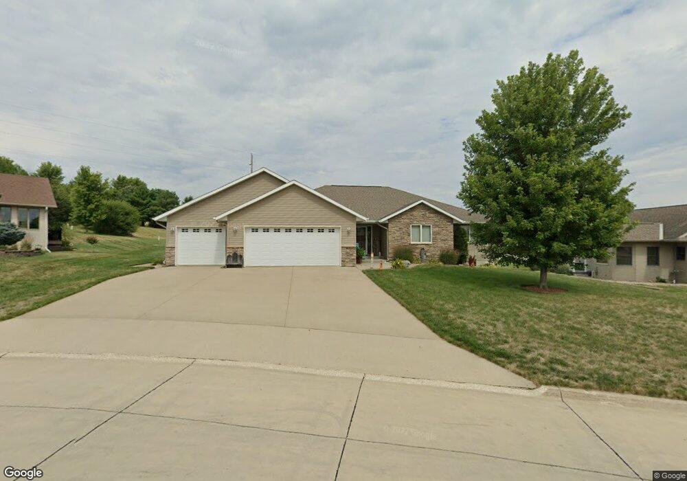
812 Maxwell Dr Carroll, IA 51401
Estimated Value: $502,000 - $542,000
4
Beds
2
Baths
2,104
Sq Ft
$251/Sq Ft
Est. Value
About This Home
This home is located at 812 Maxwell Dr, Carroll, IA 51401 and is currently estimated at $527,908, approximately $250 per square foot. 812 Maxwell Dr is a home with nearby schools including Fairview Elementary School, Adams Elementary School, and Carroll Middle School.
Ownership History
Date
Name
Owned For
Owner Type
Purchase Details
Closed on
Jul 21, 2009
Sold by
Seven R S L L P
Bought by
Clasen Jeffrey R and Clasen Vicki J
Current Estimated Value
Home Financials for this Owner
Home Financials are based on the most recent Mortgage that was taken out on this home.
Original Mortgage
$224,000
Outstanding Balance
$146,568
Interest Rate
5.36%
Mortgage Type
New Conventional
Estimated Equity
$381,340
Create a Home Valuation Report for This Property
The Home Valuation Report is an in-depth analysis detailing your home's value as well as a comparison with similar homes in the area
Home Values in the Area
Average Home Value in this Area
Purchase History
| Date | Buyer | Sale Price | Title Company |
|---|---|---|---|
| Clasen Jeffrey R | $280,000 | Security Title & Investment |
Source: Public Records
Mortgage History
| Date | Status | Borrower | Loan Amount |
|---|---|---|---|
| Open | Clasen Jeffrey R | $224,000 |
Source: Public Records
Tax History
| Year | Tax Paid | Tax Assessment Tax Assessment Total Assessment is a certain percentage of the fair market value that is determined by local assessors to be the total taxable value of land and additions on the property. | Land | Improvement |
|---|---|---|---|---|
| 2025 | $5,280 | $493,250 | $46,670 | $446,580 |
| 2024 | $53 | $426,540 | $46,670 | $379,870 |
| 2023 | $5,767 | $426,540 | $46,670 | $379,870 |
| 2022 | $5,474 | $386,550 | $43,600 | $342,950 |
| 2021 | $5,474 | $386,550 | $43,600 | $342,950 |
| 2020 | $5,589 | $386,550 | $43,600 | $342,950 |
| 2019 | $5,540 | $386,550 | $43,600 | $342,950 |
| 2018 | $5,214 | $386,550 | $43,600 | $342,950 |
| 2017 | $5,206 | $372,745 | $39,397 | $333,348 |
| 2016 | $4,986 | $348,360 | $0 | $0 |
| 2015 | $4,986 | $330,970 | $0 | $0 |
| 2014 | $4,682 | $330,970 | $0 | $0 |
Source: Public Records
Map
Nearby Homes
- 479 Deer Creek Ln
- Deer Creek Ln Lot 36
- 451 Deer Creek Ln
- 409 E Valley Dr
- 207 Ridgewood Dr
- 629 Meadow Ln
- 415 W Pleasant Ridge Rd
- 317 Arthur Neu Dr
- 222 W 2nd St
- 411 W 2nd St
- 326 N West St
- 332 N Crawford St
- 19383 U S 30
- 804 N Clark St
- 827 N Clark St
- 0 Deer Creek Ln Unit 6302348
- 827 N Main St
- 110 E 10th St
- 0 Monterey Dr Unit 6307161
- 0 Monterey Dr Unit 6137563
- 209 E Timber Creek Dr
- 820 Maxwell Dr
- 303 E Timber Creek Dr
- 807 Maxwell Dr
- 823 Maxwell Dr
- 830 Maxwell Dr
- 208 E Timber Creek Dr
- 847 Maxwell Dr
- 304 E Timber Creek Dr
- 218 E Timber Creek Dr
- 312 E Timber Creek Dr
- 861 Maxwell Dr
- 216 E Pleasant Ridge Rd
- 320 E Timber Creek Dr
- 204 E Pleasant Ridge Rd
- 850 Maxwell Dr
- 226 E Pleasant Ridge Rd
- 854 Maxwell Dr
- 306 E Pleasant Ridge Rd
- 106 E Timber Creek Dr
Your Personal Tour Guide
Ask me questions while you tour the home.