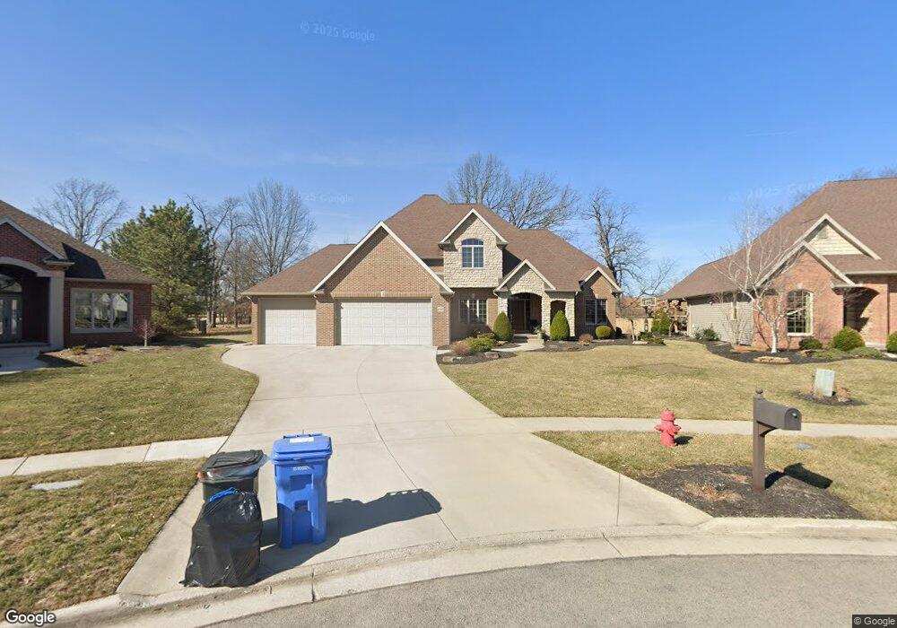
8139 Brookfield Cir Findlay, OH 45840
Estimated Value: $478,000 - $526,000
4
Beds
3
Baths
2,333
Sq Ft
$216/Sq Ft
Est. Value
About This Home
This home is located at 8139 Brookfield Cir, Findlay, OH 45840 and is currently estimated at $503,838, approximately $215 per square foot. 8139 Brookfield Cir is a home located in Hancock County with nearby schools including Wilson Vance Elementary School, Whittier Elementary School, and Glenwood Middle School.
Ownership History
Date
Name
Owned For
Owner Type
Purchase Details
Closed on
Apr 14, 2005
Sold by
Lvp Development Inc
Bought by
Kull Angela M and Geiser Clyde P
Current Estimated Value
Home Financials for this Owner
Home Financials are based on the most recent Mortgage that was taken out on this home.
Original Mortgage
$45,000
Interest Rate
5.89%
Mortgage Type
Fannie Mae Freddie Mac
Create a Home Valuation Report for This Property
The Home Valuation Report is an in-depth analysis detailing your home's value as well as a comparison with similar homes in the area
Home Values in the Area
Average Home Value in this Area
Purchase History
| Date | Buyer | Sale Price | Title Company |
|---|---|---|---|
| Kull Angela M | $45,000 | Mid Am Title Agency |
Source: Public Records
Mortgage History
| Date | Status | Borrower | Loan Amount |
|---|---|---|---|
| Closed | Kull Angela M | $45,000 |
Source: Public Records
Tax History Compared to Growth
Tax History
| Year | Tax Paid | Tax Assessment Tax Assessment Total Assessment is a certain percentage of the fair market value that is determined by local assessors to be the total taxable value of land and additions on the property. | Land | Improvement |
|---|---|---|---|---|
| 2024 | $4,972 | $139,970 | $24,810 | $115,160 |
| 2023 | $4,980 | $139,970 | $24,810 | $115,160 |
| 2022 | $4,963 | $139,970 | $24,810 | $115,160 |
| 2021 | $5,072 | $124,620 | $23,180 | $101,440 |
| 2020 | $5,072 | $124,620 | $23,180 | $101,440 |
| 2019 | $4,969 | $124,620 | $23,180 | $101,440 |
| 2018 | $5,040 | $115,930 | $14,490 | $101,440 |
| 2017 | $5,043 | $115,930 | $14,490 | $101,440 |
| 2016 | $4,946 | $115,930 | $14,490 | $101,440 |
| 2015 | $4,661 | $106,600 | $13,780 | $92,820 |
| 2014 | $4,662 | $106,600 | $13,780 | $92,820 |
| 2012 | $4,691 | $106,600 | $13,780 | $92,820 |
Source: Public Records
Map
Nearby Homes
- 7752 E Point Dr
- 0 Lakeside Dr
- 0 Forest Ln Unit Lot 258
- 8419 E Woodland Trail
- 8100 Shawnee Forest Dr
- 8130 Shawnee Forest Dr
- 7665 Brookstone Dr
- 8405 Indian Lake Dr
- 7711 E Watermark Dr
- 15329 E Us Route 224
- 0 E Us Route 224
- 0 Meadowview Dr
- 8499 Indian Lake Dr
- 7507 Township Road 212
- 16078 Forest Lake Dr
- 0 Hickory Ln Unit 1 307878
- 0 Hickory Ln Unit 20252999
- 0 Hickory Ln Unit 1
- 2309 Lonetree Dr
- 267 Sierra Ct
- 8137 Brookfield Cir
- 8141 Brookfield Cir
- 15511 Beechwood Rd
- 15511 Beechwood Rd
- 8143 Brookfield Cir
- 8135 Brookfield Cir
- 8133 Brookfield Cir
- 8145 Brookfield Cir
- 8145 Brookfield Cirlce
- 15591 Beechwood Rd
- 8147 Brookfield Cir
- 16270 Beechwood Rd
- 8146 Brookfield Dr
- 8149 Brookfield Dr
- 8131 Brookfield Cir
- 8120 Clearbrook Dr
- 15611 Beechwood Rd
- 15436 Beechwood Rd
- 8129 Brookfield Cir
- 8155 Brookfield Dr