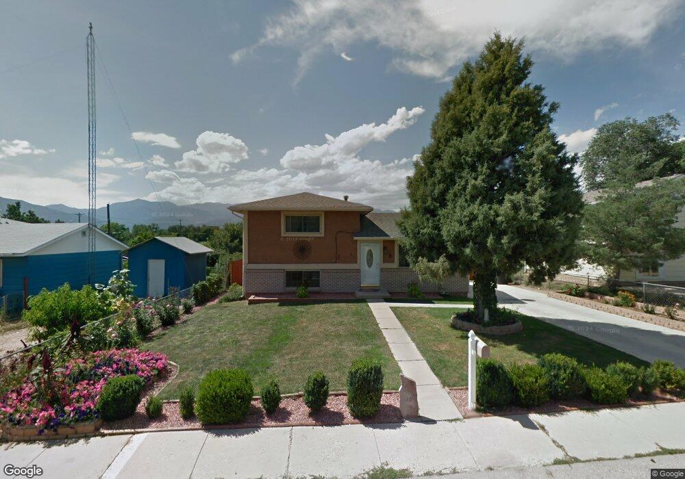
814 Hutchinson Dr Colorado Springs, CO 80910
East Lake NeighborhoodEstimated Value: $286,800 - $333,000
3
Beds
2
Baths
894
Sq Ft
$343/Sq Ft
Est. Value
About This Home
This home is located at 814 Hutchinson Dr, Colorado Springs, CO 80910 and is currently estimated at $306,700, approximately $343 per square foot. 814 Hutchinson Dr is a home located in El Paso County with nearby schools including Adams Elementary School, Galileo School Of Math And Science, and William J. Palmer High School.
Ownership History
Date
Name
Owned For
Owner Type
Purchase Details
Closed on
Feb 6, 2014
Sold by
Venzor Cruz Z
Bought by
Venzor Cruz A and Arpero Yolanda Venzor
Current Estimated Value
Purchase Details
Closed on
Dec 12, 2013
Sold by
Venzor Lorraine R
Bought by
Venzor Cruz A
Purchase Details
Closed on
Nov 9, 2001
Sold by
Pennington Lonnel
Bought by
Venzor Cruz A and Venzor Elijio A
Home Financials for this Owner
Home Financials are based on the most recent Mortgage that was taken out on this home.
Original Mortgage
$103,079
Outstanding Balance
$39,902
Interest Rate
6.59%
Mortgage Type
FHA
Estimated Equity
$266,798
Create a Home Valuation Report for This Property
The Home Valuation Report is an in-depth analysis detailing your home's value as well as a comparison with similar homes in the area
Home Values in the Area
Average Home Value in this Area
Purchase History
| Date | Buyer | Sale Price | Title Company |
|---|---|---|---|
| Venzor Cruz A | -- | None Available | |
| Venzor Cruz A | -- | None Available | |
| Venzor Cruz A | -- | None Available | |
| Venzor Cruz A | $104,000 | -- |
Source: Public Records
Mortgage History
| Date | Status | Borrower | Loan Amount |
|---|---|---|---|
| Open | Venzor Cruz A | $103,079 |
Source: Public Records
Tax History Compared to Growth
Tax History
| Year | Tax Paid | Tax Assessment Tax Assessment Total Assessment is a certain percentage of the fair market value that is determined by local assessors to be the total taxable value of land and additions on the property. | Land | Improvement |
|---|---|---|---|---|
| 2025 | $1,006 | $22,360 | -- | -- |
| 2024 | $897 | $22,500 | $3,180 | $19,320 |
| 2022 | $891 | $15,920 | $3,130 | $12,790 |
| 2021 | $967 | $16,380 | $3,220 | $13,160 |
| 2020 | $788 | $11,610 | $2,150 | $9,460 |
| 2019 | $784 | $11,610 | $2,150 | $9,460 |
| 2018 | $661 | $9,010 | $1,620 | $7,390 |
| 2017 | $626 | $9,010 | $1,620 | $7,390 |
| 2016 | $534 | $9,210 | $1,670 | $7,540 |
| 2015 | $532 | $9,210 | $1,670 | $7,540 |
| 2014 | $495 | $8,220 | $1,670 | $6,550 |
Source: Public Records
Map
Nearby Homes
- 810 Hutchinson Dr
- 810 Hayden Dr
- 2119 Saranac Dr
- 829 Hayden Dr
- 609 Placid Rd
- 931 Hayden Dr
- 807 Bryce Dr
- 818 S Circle Dr
- 2205 Airport Rd
- 706 Manitoba Dr
- 613 S Union Blvd
- 1081 Antrim Loop
- 2902 Airport Rd Unit 204
- 2902 Airport Rd Unit 116
- 2902 Airport Rd Unit 134
- 1219 Quivira Dr
- 226 Bassett Dr
- 898 Antrim Loop
- 1406 Kirkham St
- 2257 Ellingwood Dr
- 818 Hutchinson Dr
- 822 Hutchinson Dr
- 806 Hutchinson Dr
- 802 Hayden Dr
- 807 Hutchinson Dr
- 2402 Norse Dr
- 806 Hayden Dr
- 807 Hayden Dr
- 712 Winnepeg Dr
- 2406 Norse Dr
- 716 Winnepeg Dr
- 811 Hayden Dr
- 906 Hutchinson Dr
- 2141 Preuss Rd Unit C
- 2141 Preuss Rd Unit D
- 2141 Preuss Rd Unit B
- 2141 Preuss Rd Unit A
- 2410 Norse Dr
- 722 Winnepeg Dr
- 703 Winnepeg Dr