
Seller's Agent in 2025
Sasha Iyamu
ERIS, LLC
(203) 231-4921
2 in this area
106 Total Sales
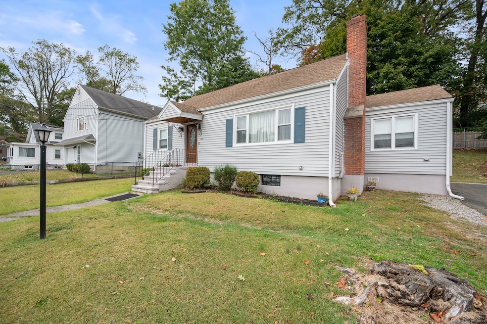
Come check out this spacious 5-bedroom, 2 full bath Cape located in the desirable North End of Bridgeport, CT. This well-maintained home features an open floor plan, an oversized, updated kitchen perfect for entertaining, and a finished basement that offers additional living space, including the fifth bedroom. Enjoy a generous backyard, ideal for cookouts, family gatherings, or simply relaxing outdoors. Whether you're looking for space, comfort, or a great location, this home has it all...
Last Agent to Sell the Property
ERIS, LLC Brokerage Phone: (203) 231-4921 License #REB.0792087 Listed on: 10/17/2025
| Date | Type | Sale Price | Title Company |
|---|---|---|---|
| Warranty Deed | $455,000 | -- | |
| Warranty Deed | $70,000 | -- | |
| Warranty Deed | $475,000 | -- | |
| Warranty Deed | $70,000 | -- | |
| Warranty Deed | $85,000 | -- | |
| Warranty Deed | $85,000 | -- |
| Date | Status | Loan Amount | Loan Type |
|---|---|---|---|
| Open | $409,500 | New Conventional | |
| Previous Owner | $177,650 | No Value Available | |
| Previous Owner | $45,000 | Purchase Money Mortgage |
| Date | Event | Price | List to Sale | Price per Sq Ft |
|---|---|---|---|---|
| 12/17/2025 12/17/25 | Sold | $455,000 | +1.1% | $232 / Sq Ft |
| 10/17/2025 10/17/25 | For Sale | $449,999 | -- | $230 / Sq Ft |
| Year | Tax Paid | Tax Assessment Tax Assessment Total Assessment is a certain percentage of the fair market value that is determined by local assessors to be the total taxable value of land and additions on the property. | Land | Improvement |
|---|---|---|---|---|
| 2025 | $6,550 | $150,750 | $73,860 | $76,890 |
| 2024 | $6,550 | $150,750 | $73,860 | $76,890 |
| 2023 | $6,550 | $150,750 | $73,860 | $76,890 |
| 2022 | $6,550 | $150,750 | $73,860 | $76,890 |
| 2021 | $6,550 | $150,750 | $73,860 | $76,890 |
| 2020 | $5,909 | $109,450 | $44,740 | $64,710 |
| 2019 | $5,909 | $109,450 | $44,740 | $64,710 |
| 2018 | $5,951 | $109,450 | $44,740 | $64,710 |
| 2017 | $5,951 | $109,450 | $44,740 | $64,710 |
| 2016 | $5,951 | $109,450 | $44,740 | $64,710 |
| 2015 | $5,606 | $132,850 | $45,110 | $87,740 |
| 2014 | $5,606 | $132,850 | $45,110 | $87,740 |
Seller's Agent in 2025
Sasha Iyamu
ERIS, LLC
(203) 231-4921
2 in this area
106 Total Sales
N
Buyer's Agent in 2025
Nidia Angeles
eXp Realty
(203) 504-5005
1 in this area
8 Total Sales
Source: SmartMLS
MLS Number: 24132513
APN: BRID-002447-000006
Disclaimer: Certain information contained herein is derived from information provided by parties other than Homes.com. All information provided is deemed reliable, but is not guaranteed to be accurate and should be independently verified.
![]() IDX information is provided exclusively for personal, non-commercial use, and may not be used for any purpose other than to identify prospective properties consumers may be interested in purchasing. Information is deemed reliable but not guaranteed.
IDX information is provided exclusively for personal, non-commercial use, and may not be used for any purpose other than to identify prospective properties consumers may be interested in purchasing. Information is deemed reliable but not guaranteed.
Ask me questions while you tour the home.