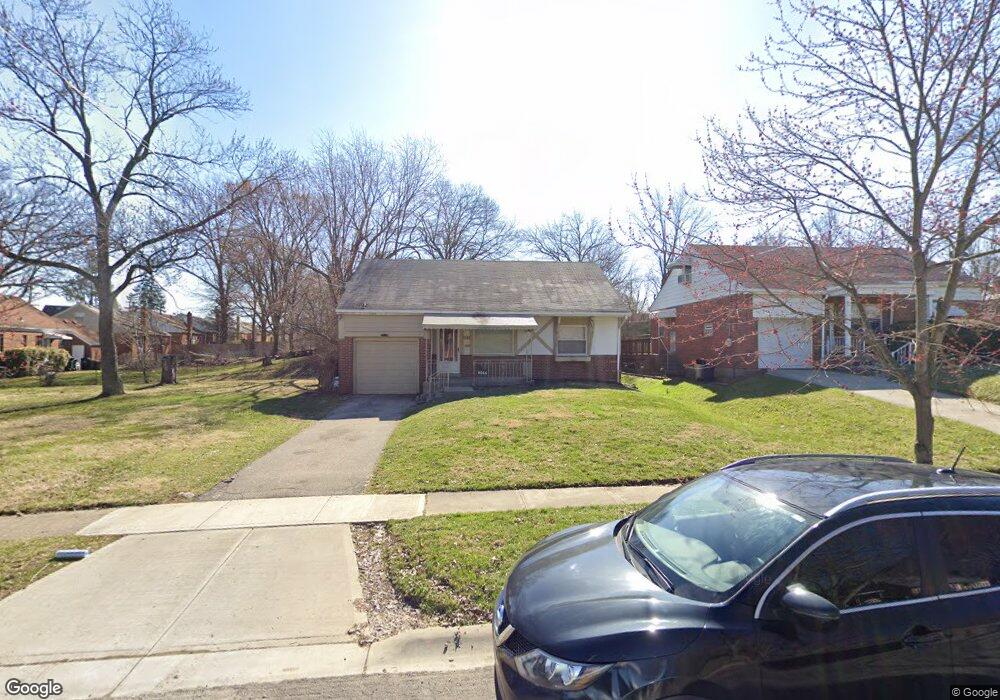
8144 Bobolink Dr Cincinnati, OH 45224
College Hill NeighborhoodEstimated Value: $190,621 - $212,000
3
Beds
1
Bath
1,261
Sq Ft
$160/Sq Ft
Est. Value
About This Home
This home is located at 8144 Bobolink Dr, Cincinnati, OH 45224 and is currently estimated at $201,905, approximately $160 per square foot. 8144 Bobolink Dr is a home located in Hamilton County with nearby schools including Pleasant Hill Elementary School, Western Hills High School, and Gilbert A. Dater High School.
Ownership History
Date
Name
Owned For
Owner Type
Purchase Details
Closed on
Feb 18, 2026
Sold by
Sheretha Page-Wooten and Page Bolden Sheretha
Bought by
Page-Wooten Sheretha
Current Estimated Value
Purchase Details
Closed on
Jun 2, 2005
Sold by
Bolden Sheretha Page and Powell Sheretha
Bought by
Bolden Sheretha Page
Home Financials for this Owner
Home Financials are based on the most recent Mortgage that was taken out on this home.
Original Mortgage
$74,000
Interest Rate
5.75%
Mortgage Type
Fannie Mae Freddie Mac
Purchase Details
Closed on
Jul 24, 1997
Sold by
Koesters William E and Koesters Barbara Jean
Bought by
Powell Sheretha
Home Financials for this Owner
Home Financials are based on the most recent Mortgage that was taken out on this home.
Original Mortgage
$72,750
Interest Rate
7.81%
Create a Home Valuation Report for This Property
The Home Valuation Report is an in-depth analysis detailing your home's value as well as a comparison with similar homes in the area
Home Values in the Area
Average Home Value in this Area
Purchase History
| Date | Buyer | Sale Price | Title Company |
|---|---|---|---|
| Page-Wooten Sheretha | -- | None Listed On Document | |
| Bolden Sheretha Page | -- | Accurate Title Solutions | |
| Powell Sheretha | $75,000 | -- |
Source: Public Records
Mortgage History
| Date | Status | Borrower | Loan Amount |
|---|---|---|---|
| Previous Owner | Bolden Sheretha Page | $74,000 | |
| Previous Owner | Powell Sheretha | $72,750 |
Source: Public Records
Tax History
| Year | Tax Paid | Tax Assessment Tax Assessment Total Assessment is a certain percentage of the fair market value that is determined by local assessors to be the total taxable value of land and additions on the property. | Land | Improvement |
|---|---|---|---|---|
| 2025 | $2,769 | $44,804 | $10,077 | $34,727 |
| 2024 | $2,685 | $44,804 | $10,077 | $34,727 |
| 2023 | $2,746 | $44,804 | $10,077 | $34,727 |
| 2022 | $1,946 | $28,459 | $8,204 | $20,255 |
| 2021 | $1,870 | $28,459 | $8,204 | $20,255 |
| 2020 | $1,925 | $28,459 | $8,204 | $20,255 |
| 2019 | $1,848 | $24,962 | $7,196 | $17,766 |
| 2018 | $1,851 | $24,962 | $7,196 | $17,766 |
| 2017 | $1,758 | $24,962 | $7,196 | $17,766 |
| 2016 | $2,132 | $29,894 | $7,679 | $22,215 |
| 2015 | $1,923 | $29,894 | $7,679 | $22,215 |
| 2014 | $1,937 | $29,894 | $7,679 | $22,215 |
| 2013 | $2,031 | $30,818 | $7,917 | $22,901 |
Source: Public Records
Map
Nearby Homes
- 7923 Bobolink Dr
- 7866 Bitteroot Ln
- 1280 Brushwood Ave
- 1291 W Galbraith Rd
- 7873 Bobolink Dr
- 7929 Cherrywood Ct
- 1165 W Galbraith Rd
- 6669 Kirkland Dr
- 1088 Pinehollow Ln
- 6917 Kleindale Ave
- 6785 Marvin Ave
- 6538 S Oak Knoll Dr
- 8491 Fernwell Dr
- 1148 Hollywood Ave
- 8634 Daly Rd
- 1297 Landis Ln
- 1144 Hempstead Dr
- 1006 Hearthstone Dr
- 8719 Hood Ct
- 7227 Bernard Ave
- 8140 Bobolink Dr
- 8061 Knollwood Ln
- 1235 W Galbraith Rd
- 8134 Bobolink Dr
- 1233 W Galbraith Rd
- 8041 Knollwood Ln
- 8081 Knollwood Ln
- 1259 W Galbraith Rd
- 8096 Bobolink Dr
- 1231 W Galbraith Rd
- 8013 Knollwood Ln
- 1263 W Galbraith Rd
- 7985 Knollwood Ln
- 8131 Bobolink Dr
- 1229 W Galbraith Rd
- 8064 Bobolink Dr
- 8077 Bobolink Dr
- 8080 Knollwood Ln
- 7967 Knollwood Ln
- 1267 W Galbraith Rd
Your Personal Tour Guide
Ask me questions while you tour the home.