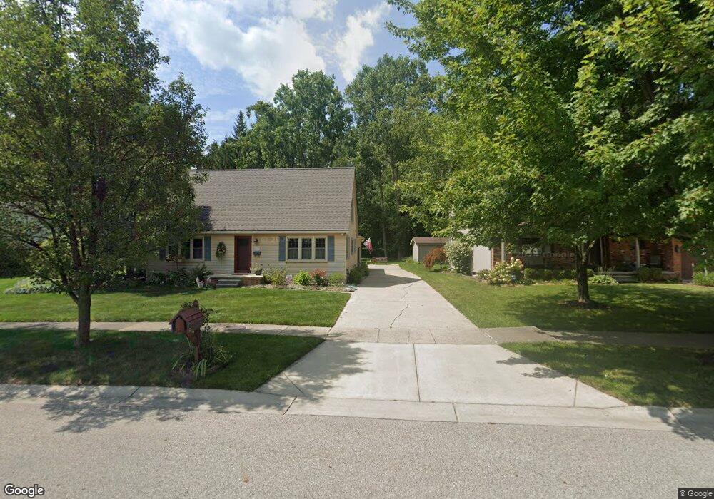
815 Carolina Marysville, MI 48040
Estimated Value: $208,791 - $227,000
3
Beds
2
Baths
1,080
Sq Ft
$202/Sq Ft
Est. Value
About This Home
This home is located at 815 Carolina, Marysville, MI 48040 and is currently estimated at $217,948, approximately $201 per square foot. 815 Carolina is a home located in St. Clair County with nearby schools including Marysville High School, St. Clair County Intervention Academy, and Blue Water SDA Elementary School.
Ownership History
Date
Name
Owned For
Owner Type
Purchase Details
Closed on
Mar 31, 2021
Sold by
Saunders Mary Beth
Bought by
Saunders Mary Beth and Saunders Roy A
Current Estimated Value
Home Financials for this Owner
Home Financials are based on the most recent Mortgage that was taken out on this home.
Original Mortgage
$63,000
Outstanding Balance
$56,790
Interest Rate
2.9%
Mortgage Type
New Conventional
Estimated Equity
$161,158
Purchase Details
Closed on
Jan 21, 2010
Sold by
Gabriel Crystal N
Bought by
Federal Home Loan Mortgage Corp
Create a Home Valuation Report for This Property
The Home Valuation Report is an in-depth analysis detailing your home's value as well as a comparison with similar homes in the area
Home Values in the Area
Average Home Value in this Area
Purchase History
| Date | Buyer | Sale Price | Title Company |
|---|---|---|---|
| Saunders Mary Beth | -- | Vanguard Title Company | |
| Federal Home Loan Mortgage Corp | $48,000 | None Available |
Source: Public Records
Mortgage History
| Date | Status | Borrower | Loan Amount |
|---|---|---|---|
| Open | Saunders Mary Beth | $63,000 |
Source: Public Records
Tax History Compared to Growth
Tax History
| Year | Tax Paid | Tax Assessment Tax Assessment Total Assessment is a certain percentage of the fair market value that is determined by local assessors to be the total taxable value of land and additions on the property. | Land | Improvement |
|---|---|---|---|---|
| 2025 | $2,241 | $91,600 | $0 | $0 |
| 2024 | $1,646 | $90,400 | $0 | $0 |
| 2023 | $1,544 | $85,000 | $0 | $0 |
| 2022 | $2,010 | $70,600 | $0 | $0 |
| 2021 | $1,902 | $66,700 | $0 | $0 |
| 2020 | $1,878 | $63,900 | $63,900 | $0 |
| 2019 | $1,843 | $52,800 | $0 | $0 |
| 2018 | $1,799 | $52,000 | $0 | $0 |
| 2017 | $1,762 | $47,800 | $0 | $0 |
| 2016 | $1,307 | $47,800 | $0 | $0 |
| 2015 | -- | $41,100 | $41,100 | $0 |
| 2014 | -- | $40,400 | $40,400 | $0 |
| 2013 | -- | $39,100 | $0 | $0 |
Source: Public Records
Map
Nearby Homes
- 0 Georgia Ave Unit 20251028141
- 0 Gratiot Blvd Unit 50105825
- 765 Lomasney Ln
- 1234 Wisconsin Ave
- 1320 Georgia Ave
- 233 Nevada Ave
- 808 5th St
- 000 Montana Ave
- 1329 Vermont Ave
- 240 Oregon Ave
- 1504 Colorado St
- 250 Oregon Ave
- 4601 Gratiot Rd
- 275 Maywood St Unit 13
- 277 Liberty Ave
- 260 Capitol Dr
- 105 Joan Ct
- 4745 Smiths Creek Rd
- 1660 New York Ave
- 833 Range Rd