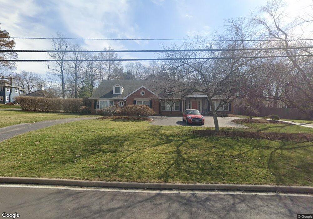
816 S Warson Rd Saint Louis, MO 63124
Estimated Value: $1,753,000 - $1,928,000
4
Beds
4
Baths
5,125
Sq Ft
$354/Sq Ft
Est. Value
About This Home
This home is located at 816 S Warson Rd, Saint Louis, MO 63124 and is currently estimated at $1,811,774, approximately $353 per square foot. 816 S Warson Rd is a home located in St. Louis County with nearby schools including Conway Elementary, Ladue 5th Grade Center, and Ladue Middle School.
Ownership History
Date
Name
Owned For
Owner Type
Purchase Details
Closed on
Dec 18, 2015
Sold by
Dicera Enrico and Gurrieri Maria
Bought by
The Di Cera Gurrieri Qualified Spousal T and Gurrieri Maria
Current Estimated Value
Purchase Details
Closed on
May 11, 1999
Sold by
Gordon Newton and Gordon Carla M
Bought by
Dicera Enrico and Gurrieri Maria
Home Financials for this Owner
Home Financials are based on the most recent Mortgage that was taken out on this home.
Original Mortgage
$536,000
Outstanding Balance
$139,411
Interest Rate
7.12%
Estimated Equity
$1,672,363
Create a Home Valuation Report for This Property
The Home Valuation Report is an in-depth analysis detailing your home's value as well as a comparison with similar homes in the area
Home Values in the Area
Average Home Value in this Area
Purchase History
| Date | Buyer | Sale Price | Title Company |
|---|---|---|---|
| The Di Cera Gurrieri Qualified Spousal T | -- | None Available | |
| Dicera Enrico | $670,000 | -- |
Source: Public Records
Mortgage History
| Date | Status | Borrower | Loan Amount |
|---|---|---|---|
| Open | Dicera Enrico | $536,000 |
Source: Public Records
Tax History
| Year | Tax Paid | Tax Assessment Tax Assessment Total Assessment is a certain percentage of the fair market value that is determined by local assessors to be the total taxable value of land and additions on the property. | Land | Improvement |
|---|---|---|---|---|
| 2025 | $16,519 | $304,250 | $207,180 | $97,070 |
| 2024 | $16,519 | $244,760 | $90,100 | $154,660 |
| 2023 | $16,488 | $244,760 | $90,100 | $154,660 |
| 2022 | $12,519 | $179,040 | $90,350 | $88,690 |
| 2021 | $11,908 | $179,040 | $90,350 | $88,690 |
| 2020 | $14,568 | $217,890 | $105,030 | $112,860 |
| 2019 | $14,355 | $217,890 | $105,030 | $112,860 |
| 2018 | $11,781 | $165,070 | $82,610 | $82,460 |
| 2017 | $11,731 | $165,070 | $82,610 | $82,460 |
| 2016 | $12,633 | $171,990 | $82,610 | $89,380 |
Source: Public Records
Map
Nearby Homes
- 9 Warson Terrace
- 31 Conway Close Rd
- 10067 Springwood Dr
- 718 Woods of Ladue Ln
- 5 Clerbrook Ln
- 233 S Warson Rd
- 10340 Savannah Ave
- 31 Midpark Ln
- 1 Clermont Ln
- 14 Ballantrae Ct
- 68 Woodoaks Trail
- 22 Fordyce Ln
- 11 Chatfield Place Rd
- 11 Fordyce Ln
- 1691 Frontenac Woods Ln
- 18 Oakleigh Ln
- 9998 Litzsinger Rd
- 15 Lawrence Dr
- 9820 Warington Square
- 21 Ramsgate Dr
Your Personal Tour Guide
Ask me questions while you tour the home.