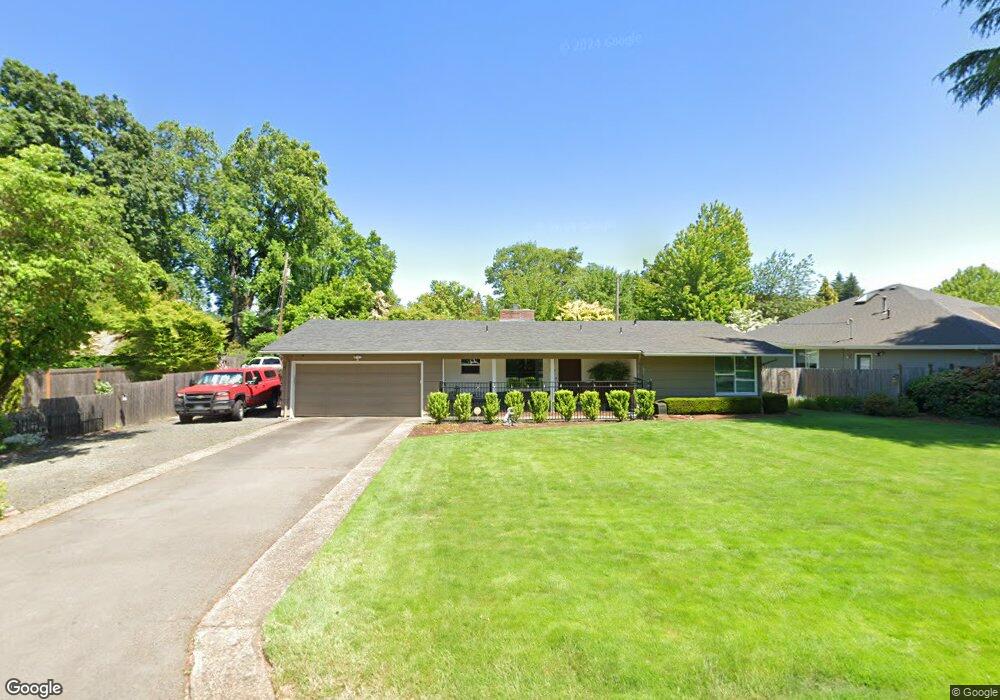
817 Lariat Dr Eugene, OR 97401
Cal Young NeighborhoodEstimated Value: $537,000 - $552,343
3
Beds
2
Baths
1,448
Sq Ft
$376/Sq Ft
Est. Value
About This Home
This home is located at 817 Lariat Dr, Eugene, OR 97401 and is currently estimated at $545,086, approximately $376 per square foot. 817 Lariat Dr is a home located in Lane County with nearby schools including Willagillespie Elementary School, Monroe Middle School, and Sheldon High School.
Ownership History
Date
Name
Owned For
Owner Type
Purchase Details
Closed on
Sep 19, 2011
Sold by
Martin Janet E
Bought by
Mcdonald Todd M and Mcdonald Kathleen M
Current Estimated Value
Home Financials for this Owner
Home Financials are based on the most recent Mortgage that was taken out on this home.
Original Mortgage
$199,500
Outstanding Balance
$136,119
Interest Rate
4.26%
Mortgage Type
New Conventional
Estimated Equity
$408,967
Create a Home Valuation Report for This Property
The Home Valuation Report is an in-depth analysis detailing your home's value as well as a comparison with similar homes in the area
Home Values in the Area
Average Home Value in this Area
Purchase History
| Date | Buyer | Sale Price | Title Company |
|---|---|---|---|
| Mcdonald Todd M | $210,000 | Fidelity National Title Insu |
Source: Public Records
Mortgage History
| Date | Status | Borrower | Loan Amount |
|---|---|---|---|
| Open | Mcdonald Todd M | $199,500 |
Source: Public Records
Tax History
| Year | Tax Paid | Tax Assessment Tax Assessment Total Assessment is a certain percentage of the fair market value that is determined by local assessors to be the total taxable value of land and additions on the property. | Land | Improvement |
|---|---|---|---|---|
| 2025 | $4,853 | $249,070 | -- | -- |
| 2024 | $4,792 | $241,816 | -- | -- |
| 2023 | $4,792 | $234,773 | -- | -- |
| 2022 | $4,490 | $227,935 | $0 | $0 |
| 2021 | $4,217 | $221,297 | $0 | $0 |
| 2020 | $4,232 | $214,852 | $0 | $0 |
| 2019 | $4,087 | $208,595 | $0 | $0 |
| 2018 | $3,847 | $196,621 | $0 | $0 |
| 2017 | $3,675 | $196,621 | $0 | $0 |
| 2016 | $3,584 | $190,894 | $0 | $0 |
| 2015 | $3,481 | $185,334 | $0 | $0 |
| 2014 | $3,411 | $179,936 | $0 | $0 |
Source: Public Records
Map
Nearby Homes
- 820 Lariat Dr
- 2250 Turnberry Ct
- 1090 Corydon St
- 950 Coburg Rd
- 2345 Pioneer Pike
- 2150 Greenview St
- 600 Cherry Dr Unit 8
- 600 Cherry Dr Unit 3
- 347 Rustic Place Unit 14
- 2746 Harlow Rd
- 367 Rustic Place
- 2872 Suffolk Ct
- 394 Cherry Dr
- 327 Rustic Place Unit 35
- 1521 Gilham Rd
- 2746 Norbert Ln
- 2084 Eastwood Ln
- 0 Cal Young Rd Unit Lot 4
- 2015 Eastwood Ln
- 2036 Eastwood Ln
- 821 Lariat Dr
- 811 Lariat Dr
- 825 Lariat Dr
- 814 Lariat Dr
- 808 Lariat Dr
- 2424 Lariat Meadows Dr
- 800 Lariat Dr
- 2470 Lariat Meadows Dr
- 832 Lariat Dr
- 2390 Lariat Dr
- 2490 Lariat Meadows Dr
- 895 Lariat Dr
- 2444 Lariat Meadows Dr
- 833 Lariat Dr
- 907 Lariat Dr
- 2395 Lariat Dr
- 889 Lariat Dr
- 955 Lariat Dr
- 977 Lariat Dr
- 2425 Lariat Meadows Dr
Your Personal Tour Guide
Ask me questions while you tour the home.