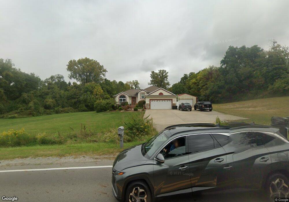
818 Moorefield Rd Springfield, OH 45502
Estimated Value: $341,406 - $412,000
3
Beds
3
Baths
1,588
Sq Ft
$235/Sq Ft
Est. Value
About This Home
This home is located at 818 Moorefield Rd, Springfield, OH 45502 and is currently estimated at $373,852, approximately $235 per square foot. 818 Moorefield Rd is a home located in Clark County with nearby schools including Northridge Elementary School, Kenton Ridge Middle & High School, and Emmanuel Christian Academy.
Ownership History
Date
Name
Owned For
Owner Type
Purchase Details
Closed on
Mar 5, 2010
Sold by
Clawson Michael D and Clawson Melissa B
Bought by
Clawson Michael D and Clawson Melissa B
Current Estimated Value
Purchase Details
Closed on
Sep 18, 2003
Sold by
Bolen Larry A
Bought by
Clawson Michael D and Clawson Melissa B
Home Financials for this Owner
Home Financials are based on the most recent Mortgage that was taken out on this home.
Original Mortgage
$191,265
Outstanding Balance
$93,899
Interest Rate
6.23%
Mortgage Type
Construction
Estimated Equity
$279,953
Create a Home Valuation Report for This Property
The Home Valuation Report is an in-depth analysis detailing your home's value as well as a comparison with similar homes in the area
Home Values in the Area
Average Home Value in this Area
Purchase History
| Date | Buyer | Sale Price | Title Company |
|---|---|---|---|
| Clawson Michael D | -- | Attorney | |
| Clawson Michael D | $32,500 | Commerce Title Company |
Source: Public Records
Mortgage History
| Date | Status | Borrower | Loan Amount |
|---|---|---|---|
| Open | Clawson Michael D | $191,265 |
Source: Public Records
Tax History
| Year | Tax Paid | Tax Assessment Tax Assessment Total Assessment is a certain percentage of the fair market value that is determined by local assessors to be the total taxable value of land and additions on the property. | Land | Improvement |
|---|---|---|---|---|
| 2025 | $3,833 | $101,870 | $20,730 | $81,140 |
| 2024 | $3,707 | $87,550 | $16,080 | $71,470 |
| 2023 | $3,707 | $87,550 | $16,080 | $71,470 |
| 2022 | $3,721 | $87,550 | $16,080 | $71,470 |
| 2021 | $3,625 | $72,280 | $13,180 | $59,100 |
| 2020 | $3,628 | $72,280 | $13,180 | $59,100 |
| 2019 | $3,697 | $72,280 | $13,180 | $59,100 |
| 2018 | $3,392 | $63,630 | $12,210 | $51,420 |
| 2017 | $2,908 | $63,623 | $12,208 | $51,415 |
| 2016 | $2,888 | $63,623 | $12,208 | $51,415 |
| 2015 | $2,796 | $59,325 | $12,208 | $47,117 |
| 2014 | $2,796 | $59,325 | $12,208 | $47,117 |
| 2013 | $2,731 | $59,325 | $12,208 | $47,117 |
Source: Public Records
Map
Nearby Homes
- 862 Brendle Trace Unit 20
- 4741 Cullen Ave
- 4802 Willowbrook Dr
- 593 Hiser Ave
- 4343 Burchill St
- 5033 Ridgewood Rd E
- 1521 Erika Dr
- 0 Moorefield Rd
- 5564 Ridgewood Rd W
- 1341 Student Ave
- 1495 Victorian Way
- 1709 Thomas Dr
- 937 Willow Rd
- 5564 Ridgewood Rd E Unit 7
- 4446 Ridgewood Rd E Unit 3
- 335 Willow Rd
- 4577 Reno Ln Unit 2
- 4652 Reno Ln Unit 15
- 4256 Midfield St Unit 9
- 1707 Berwick Dr
- 791 Moorefield Rd
- 842 Moorefield Rd
- 785 Falkirk Dr
- 839 Moorefield Rd
- 725 Falkirk Dr
- 820 Falkirk Dr
- 5065 Brookshire Ln
- 730 Falkirk Dr
- 750 Falkirk Dr
- 5110 Brookshire Ln
- 5095 Brookshire Ln
- 5040 Hearthstone Dr
- 4945 Derr Rd
- 5140 Brookshire Ln
- 5125 Brookshire Ln
- 5070 Hearthstone Dr
- 715 Moorefield Ct
- 983 Moorefield Rd
- 5015 Hearthstone Dr
- 5025 Hearthstone Dr
Your Personal Tour Guide
Ask me questions while you tour the home.