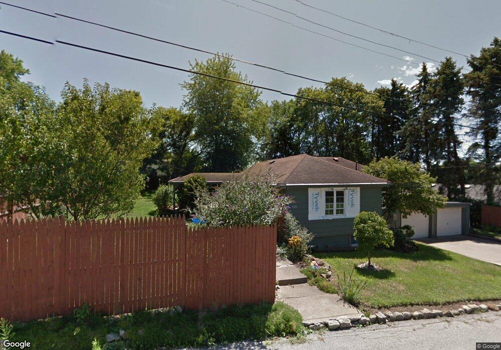
8184 Alfred St Masury, OH 44438
Estimated Value: $66,000 - $105,000
2
Beds
1
Bath
840
Sq Ft
$100/Sq Ft
Est. Value
About This Home
This home is located at 8184 Alfred St, Masury, OH 44438 and is currently estimated at $84,158, approximately $100 per square foot. 8184 Alfred St is a home located in Trumbull County with nearby schools including Brookfield Elementary School, Brookfield Middle School, and Brookfield High School.
Ownership History
Date
Name
Owned For
Owner Type
Purchase Details
Closed on
May 28, 2021
Sold by
Dubrasky Deborah
Bought by
Demaria Daniel K and Demaria Aimee N
Current Estimated Value
Purchase Details
Closed on
Sep 10, 2018
Sold by
Fedele Amy
Bought by
Nubrosky Deborah
Purchase Details
Closed on
Aug 21, 2003
Sold by
Higgins John T
Bought by
Kephart Shawn and Fedele Amy
Home Financials for this Owner
Home Financials are based on the most recent Mortgage that was taken out on this home.
Original Mortgage
$35,900
Interest Rate
5.62%
Mortgage Type
New Conventional
Purchase Details
Closed on
Jan 1, 1990
Bought by
John T Higgins
Create a Home Valuation Report for This Property
The Home Valuation Report is an in-depth analysis detailing your home's value as well as a comparison with similar homes in the area
Home Values in the Area
Average Home Value in this Area
Purchase History
| Date | Buyer | Sale Price | Title Company |
|---|---|---|---|
| Demaria Daniel K | $16,000 | None Available | |
| Nubrosky Deborah | -- | None Available | |
| Kephart Shawn | $35,900 | -- | |
| John T Higgins | -- | -- |
Source: Public Records
Mortgage History
| Date | Status | Borrower | Loan Amount |
|---|---|---|---|
| Previous Owner | Kephart Shawn | $35,900 |
Source: Public Records
Tax History Compared to Growth
Tax History
| Year | Tax Paid | Tax Assessment Tax Assessment Total Assessment is a certain percentage of the fair market value that is determined by local assessors to be the total taxable value of land and additions on the property. | Land | Improvement |
|---|---|---|---|---|
| 2024 | $1,145 | $24,190 | $1,610 | $22,580 |
| 2023 | $1,145 | $24,190 | $1,610 | $22,580 |
| 2022 | $697 | $11,900 | $1,610 | $10,290 |
| 2021 | $654 | $11,900 | $1,610 | $10,290 |
| 2020 | $650 | $11,900 | $1,610 | $10,290 |
| 2019 | $663 | $11,310 | $1,610 | $9,700 |
| 2018 | $640 | $11,310 | $1,610 | $9,700 |
| 2017 | $639 | $11,310 | $1,610 | $9,700 |
| 2016 | $567 | $9,630 | $1,610 | $8,020 |
| 2015 | $568 | $9,630 | $1,610 | $8,020 |
| 2014 | $565 | $9,630 | $1,610 | $8,020 |
| 2013 | $589 | $10,220 | $1,610 | $8,610 |
Source: Public Records
Map
Nearby Homes
- 8199 Lorain St SE
- 609 Syme St
- 545 & 625 Davis St
- 766 S Irvine Ave
- 691 S Irvine Ave
- 365 Brookfield Ave
- 268 Ridge Way
- 268 Malleable St
- 449 N Water Ave
- 334 E State St
- 655 New Castle Ave
- 1120 Wallis Ave
- 92 2nd Ave
- 276 Lincoln St
- 221 S Oakland Ave
- 191 2nd Ave
- 872 Yankee Run Rd
- 582 Spruce Ave
- 632 Spruce Ave
- 305 Sheridan St