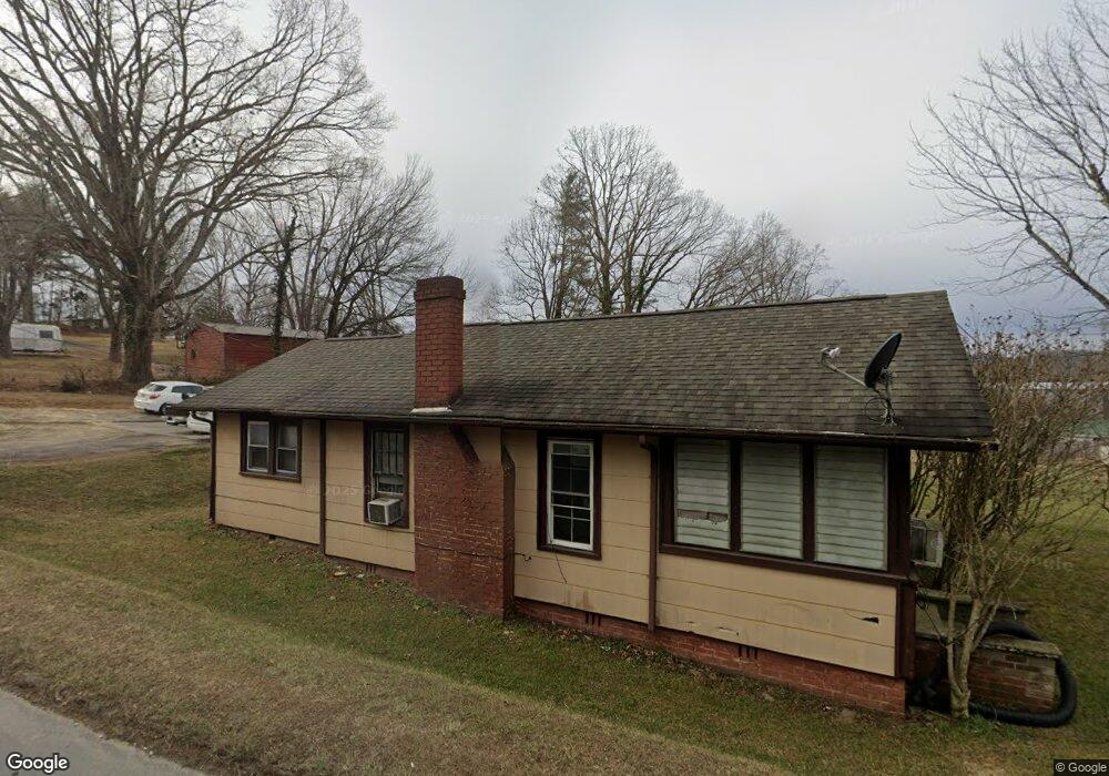
819 Duncan Hill Rd Hendersonville, NC 28792
Estimated Value: $147,000 - $271,000
2
Beds
1
Bath
844
Sq Ft
$255/Sq Ft
Est. Value
About This Home
This home is located at 819 Duncan Hill Rd, Hendersonville, NC 28792 and is currently estimated at $214,818, approximately $254 per square foot. 819 Duncan Hill Rd is a home located in Henderson County with nearby schools including Sugarloaf Elementary School, Hendersonville Middle School, and Hendersonville High School.
Ownership History
Date
Name
Owned For
Owner Type
Purchase Details
Closed on
Mar 24, 2017
Sold by
Ball James P
Bought by
Pesty Sylviane F
Current Estimated Value
Home Financials for this Owner
Home Financials are based on the most recent Mortgage that was taken out on this home.
Original Mortgage
$82,400
Outstanding Balance
$68,331
Interest Rate
4.17%
Mortgage Type
New Conventional
Estimated Equity
$146,488
Create a Home Valuation Report for This Property
The Home Valuation Report is an in-depth analysis detailing your home's value as well as a comparison with similar homes in the area
Home Values in the Area
Average Home Value in this Area
Purchase History
| Date | Buyer | Sale Price | Title Company |
|---|---|---|---|
| Pesty Sylviane F | $103,000 | -- |
Source: Public Records
Mortgage History
| Date | Status | Borrower | Loan Amount |
|---|---|---|---|
| Open | Pesty Sylviane F | $82,400 |
Source: Public Records
Tax History Compared to Growth
Tax History
| Year | Tax Paid | Tax Assessment Tax Assessment Total Assessment is a certain percentage of the fair market value that is determined by local assessors to be the total taxable value of land and additions on the property. | Land | Improvement |
|---|---|---|---|---|
| 2025 | $610 | $117,100 | $33,100 | $84,000 |
| 2024 | $610 | $117,100 | $33,100 | $84,000 |
| 2023 | $610 | $117,100 | $33,100 | $84,000 |
| 2022 | $545 | $82,400 | $22,100 | $60,300 |
| 2021 | $545 | $82,400 | $22,100 | $60,300 |
| 2020 | $545 | $82,400 | $0 | $0 |
| 2019 | $545 | $82,400 | $0 | $0 |
| 2018 | $490 | $74,300 | $0 | $0 |
| 2017 | $490 | $74,300 | $0 | $0 |
| 2016 | $490 | $74,300 | $0 | $0 |
| 2015 | -- | $74,300 | $0 | $0 |
| 2014 | -- | $73,300 | $0 | $0 |
Source: Public Records
Map
Nearby Homes
- 19 Caroline Valley Ln
- 13 Caroline Valley Ln
- 5 Caroline Valley Ln
- 64 Lillian Ln
- 25 Caroline Valley Ln
- Robie Plan at Providence Walk
- Elston Plan at Providence Walk
- Maywood Plan at Providence Walk
- Darwin Plan at Providence Walk
- Rachel Plan at Providence Walk
- 73 Lauren Ln
- 999 Linda Vista Dr
- 54 Lake Pointe Cir
- 410 Freeman St
- 200 Cranbrook Cir
- 201 Cranbrook Cir
- 402 Deerfield Ct
- 302 Meadowbrook Ct
- 501 Orrs Camp Rd
- Carson Plan at The Townes at Stonecrest
- 110 Baldwin Hill Ave
- 106 Baldwin Hill Ave
- 723 Duncan Hill Rd
- 100 Azalea Bush Ln
- 110 Baldwin Ave
- 710 Duncan Hill Rd
- 00 Duncan Hill Rd
- 0 Signal Hill Rd Unit 3275530
- 0 Signal Hill Rd Unit CAR3855739
- 0 Signal Hill Rd Unit 3480904
- 17 Aiken Place Rd
- 0 Signal Hill Unit NCM452108
- 00 Signal Hill
- 2005 N Main St
- 8 Clear Creek Rd
- 88 Denny Ln
- 2065 N Main St
- 78 Aiken Place Rd
- 58 Denny Ln
- Lot 7 Southern Knoll