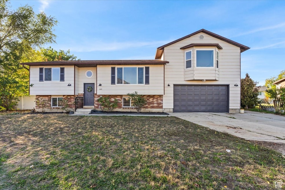
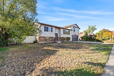


819 W 2300 N Provo, UT 84604
Riverside NeighborhoodEstimated payment $3,244/month
Highlights
- Mature Trees
- No HOA
- 2 Car Attached Garage
- Mountain View
- Balcony
- In-Law or Guest Suite
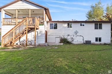
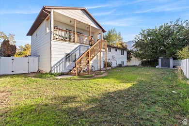
About This Home
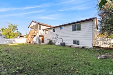
**3 KITCHENS!!** Check out this awesome opportunity PERFECTLY centered between UVU and BYU! This home has a studio apartment above the garage (Currently rented, $1125/month), the tenant is on a month-to-month but may be willing to resign a lease or move out. Tenant has been fantastic! The upstairs as well as the studio were renovated at the end of 2023 with new carpet, floors, some new appliances, etc. The roof was replaced within the last 5 years and some plumbing/electrical was redone. The basement has new flooring in the kitchen and one of the 2 bedrooms, and the bathroom was recently redone. The garage is HUGE! You can easily fit two cars with tons of space in front of them, not including all the shelving space on the side. There is also a 220V charger installed for EV vehicles! There is a wall in the garage currently because at one point this home was being rented as 3 separate units. The basement was its own apartment, the upstairs was another and then the studio above the garage. This home could be a fantastic investment for anyone who needs some rental income to help qualify on the property. Feel free to reach out if you have questions as to how that would all work! Seller is also open to seller financing if there is enough of a down payment. Thanks for checking it out!
Listing Agent
Keagan Mataele
SURV REAL ESTATE INC License #11868096 Listed on: 10/23/2025
Home Details
Home Type
- Single Family
Est. Annual Taxes
- $3,500
Year Built
- Built in 1981
Lot Details
- 8,276 Sq Ft Lot
- Property is Fully Fenced
- Landscaped
- Sprinkler System
- Mature Trees
- Property is zoned Single-Family
Parking
- 2 Car Attached Garage
- 5 Open Parking Spaces
Home Design
- Split Level Home
- Clapboard
- Asphalt
Interior Spaces
- 2,464 Sq Ft Home
- 2-Story Property
- Double Pane Windows
- Mountain Views
- Gas Dryer Hookup
Flooring
- Carpet
- Laminate
Bedrooms and Bathrooms
- 4 Bedrooms | 2 Main Level Bedrooms
- In-Law or Guest Suite
Basement
- Basement Fills Entire Space Under The House
- Exterior Basement Entry
- Apartment Living Space in Basement
Schools
- Westridge Elementary School
- Provo High School
Utilities
- Central Heating and Cooling System
- Natural Gas Connected
Additional Features
- Balcony
- Accessory Dwelling Unit (ADU)
Community Details
- No Home Owners Association
- Heritage Heights Subdivision
Listing and Financial Details
- Assessor Parcel Number 41-107-0003
Map
Home Values in the Area
Average Home Value in this Area
Tax History
| Year | Tax Paid | Tax Assessment Tax Assessment Total Assessment is a certain percentage of the fair market value that is determined by local assessors to be the total taxable value of land and additions on the property. | Land | Improvement |
|---|---|---|---|---|
| 2025 | $2,580 | $277,145 | $168,400 | $335,500 |
| 2024 | $2,580 | $253,935 | $0 | $0 |
| 2023 | $2,628 | $254,980 | $0 | $0 |
| 2022 | $2,600 | $254,430 | $0 | $0 |
| 2021 | $2,005 | $342,100 | $106,900 | $235,200 |
| 2020 | $1,932 | $309,100 | $97,200 | $211,900 |
| 2019 | $1,730 | $287,900 | $90,200 | $197,700 |
| 2018 | $1,534 | $258,900 | $83,300 | $175,600 |
| 2017 | $1,446 | $134,090 | $0 | $0 |
| 2016 | $1,547 | $133,705 | $0 | $0 |
| 2015 | $1,358 | $118,580 | $0 | $0 |
| 2014 | $1,273 | $115,940 | $0 | $0 |
Property History
| Date | Event | Price | List to Sale | Price per Sq Ft |
|---|---|---|---|---|
| 10/23/2025 10/23/25 | For Sale | $560,000 | -- | $227 / Sq Ft |
Purchase History
| Date | Type | Sale Price | Title Company |
|---|---|---|---|
| Warranty Deed | -- | Horizon Title Insurance | |
| Interfamily Deed Transfer | -- | Horizon Title Insurance | |
| Interfamily Deed Transfer | -- | Horizon Title Insurance |
Mortgage History
| Date | Status | Loan Amount | Loan Type |
|---|---|---|---|
| Closed | $33,950 | Stand Alone Second |
Source: UtahRealEstate.com
MLS Number: 2119077
APN: 41-107-0003
Disclaimer: Certain information contained herein is derived from information provided by parties other than Homes.com. All information provided is deemed reliable, but is not guaranteed to be accurate and should be independently verified.
![]() IDX information is provided exclusively for consumers’ personal, non-commercial use, that it may not be used for any purpose other than to identify prospective properties consumers may be interested in purchasing, and that the data is deemed reliable but is not guaranteed accurate by the MLS. Licensor is only providing the MLS Content and not other sources of data provided in the Product.
IDX information is provided exclusively for consumers’ personal, non-commercial use, that it may not be used for any purpose other than to identify prospective properties consumers may be interested in purchasing, and that the data is deemed reliable but is not guaranteed accurate by the MLS. Licensor is only providing the MLS Content and not other sources of data provided in the Product.
Based on information from the Wasatch Front Regional Multiple Listing Service, Inc.. All data, including all measurements and calculations of area, is obtained from various sources and has not been, and will not be, verified by broker or the MLS. All information should be independently reviewed and verified for accuracy. Properties may or may not be listed by the office/agent presenting the information.
- 814 E 1740 S
- 2241 N 1060 W
- 1939 N 700 W
- 1009 W 2000 N
- 696 E 1700 S
- 691 E 1600 S
- 666 E 1600 S
- 1927 Columbia Ln
- 720 E 1500 S
- 1763 Willowbrook Dr Unit 4D1
- 1661 Willowbrook Dr
- 1685 Hickory Ln
- 1633 Woodland Dr
- 1360 S Carterville Rd
- 920 W Columbia Ln
- 493 E 2000 S
- 444 1600 S Unit 1
- 1559 N Riverside Ave Unit 4
- 1311 S 1100 E
- 414 E 1834 S
- 1733 S 750 E Unit 1731
- 2300 N University Pkwy
- 2340 N 400 W
- 1851 S Columbia Ln
- 667 E 1650 S Unit Upstairs
- 1710 Hickory Ln
- 504 W 1720 N Unit 504
- 449 W 1720 N
- 1640 S State St Unit Executive Suite
- 1541 N Riverside Ave Unit 15
- 1547 N Riverside Ave Unit 54-C
- 1757 Village Ln
- 1460 S State St
- 1245 Riverside Ave Unit 37
- 1227 Riverside Ave Unit 60
- 1918 N Canyon Rd
- 1378 N Freedom Blvd
- 1425 N University Ave
- 1555 N Canyon
- 108 W 1230 N St